username
X
password
register
for free!
help
ArticlesGuidesRoutes
 
Photosets
 
 Comments
triplogs   photosets   labels comments more
Temporal Gulch Trail #595 - 11 members in 22 triplogs have rated this an average 3.7 ( 1 to 5 best )
1, 2  Next
22 triplogs
login for filter options
Dec 10 2023
avatar

 Guides 73
 Routes 176
 Photos 10,174
 Triplogs 2,324

46 male
 Joined Sep 08 2006
 
Old Baldy Trail #372 to Wrightson SummitTucson, AZ
Tucson, AZ
Hiking avatar Dec 10 2023
JimTriplogs 2,324
Hiking11.90 Miles 4,100 AEG
Hiking11.90 Miles
4,100 ft AEG10 LBS Pack
 
Partners none no partners
What a difference a week makes. A remarkably similar forecast and yet it was much warmer today. I was comfortable shirtless on the summit around 3 PM with calm air, and I never needed my coat. Perfectly calm and silent up there, too. Most of the snow is gone.

Bruce Mountain in the Mustang Mountains got postponed, so I thought I would check out McBeth Spring and then head for the summit. I went up #134 to Josephine Saddle, out to McBeth where I relaxed for a while, and then the rest of the summit on the standard route. I didn't want to hike out much after dark, so skipped the descent on #134 and just did it the usual way.

The huge Apache Pines at McBeth were very impressive. Flow remains good and the tank was clear.

I summited that little hill off the trail below the switchbacks to the summit. Why not?


Summit #57
 Named place
 Named place [ checklist ]
[ checklist ]  McBeth Spring

water 1 out of 5water 2 out of 5water 3 out of 5water less than max McBeth Spring Gallon per minute Gallon per minute
Looked good.

water 1 out of 5water less than maxwater less than maxwater less than max Sprung Spring Dripping Dripping
Tank was full of clear water.
_____________________
🍭
 
Jun 03 2022
avatar

 Routes 3
 Triplogs 3

male
 Joined Mar 07 2022
 Tucson, AZ
Wrightson up the steep side, AZ 
Wrightson up the steep side, AZ
 
Hiking avatar Jun 03 2022
JMountTriplogs 3
Hiking7.87 Miles 2,523 AEG
Hiking7.87 Miles   3 Hrs   46 Mns   2.38 mph
2,523 ft AEG      28 Mns Break15 LBS Pack
 
no photosets
1st trip
Route Scout Route Recorded  on Route Scout | Pop | Map | Popup | MapDEX
I took the rode less traveled and missed the destination. I will attempt it again.
 
Nov 30 2021
avatar

 Guides 187
 Routes 990
 Photos 12,079
 Triplogs 865

72 male
 Joined Jun 27 2015
 Tucson, Arizona
Josephine Saddle, AZ 
Josephine Saddle, AZ
 
Hiking avatar Nov 30 2021
markthurman53Triplogs 865
Hiking8.99 Miles 1,983 AEG
Hiking8.99 Miles   5 Hrs   18 Mns   1.89 mph
1,983 ft AEG      32 Mns Break
 
Linked   linked  
Partners partners
mamakatt22
One more hike for November. Ginny has never been to the Santa Rita's so we did the Old Baldy to Josephine Saddle. Once there we decided to go a little further and check out McBeth Spring and once there we went a little further, I wanted to show her Josephine Peak. I told her that's the peak I lost my shirt two years ago, proving you can lose your shirt in other places other than Vegas. We returned the way we came but took the super long trail back.

McBeth spring had a trickle of water and Sprung Spring along the Super Trail had water also. I have been on the super trail a few times, the first time because I have never been on it, the 2nd and possibly 3rd time because it was my return route on some hikes to the east of it and finally this time because Ginny has never been on it. I hate it, It is almost twice as long as the old baldy to Josephine Saddle; all to save yourself a little steep trail hiking on the Old Baldy. The same is true on the upper section to the summit. Temporal Gulch trail was in good shape at least to just below Josephine Peak.
_____________________
 
Sep 25 2021
avatar

 Guides 2
 Routes 10
 Photos 42
 Triplogs 893

58 male
 Joined Jul 12 2012
 Oro Valley, AZ
Vault Mine - Josephine Saddle LoopTucson, AZ
Tucson, AZ
Hiking avatar Sep 25 2021
SpiderLegsTriplogs 893
Hiking10.10 Miles 2,370 AEG
Hiking10.10 Miles   4 Hrs   33 Mns   2.22 mph
2,370 ft AEG
 no routesno photosets
Just about perfect weather for hiking, hit the parking lot and it was 59 degrees and I had to throw on some arm warmers for the first mile or so. Uneventful stroll up Vault Mine and over to Agua Caliente trail. This about the only place where you are not swimming in knee high to chest high grass and weeds around town it seems. Heading down Agua Caliente and a deer pops in front of me and oddly just stands there without moving. Simply stands there and looks at me, then turned around and noticed the reason why. A tiny fawn was 10 yards away and attempting to rejoin their mother. Scooted along once I figured that out and let the family reunion begin. Lots of deer out today, saw at least a half dozen more along the way.

The reason for my hike is that I just finished up the book that details the tragedy of the three Boy Scouts who perished up in the Santa Rita's and I wanted to see where they had fallen. Had never been on Temporal Gulch trail and poked around there for a bit. Went roughly a mile and half down Temporal Gulch to get the lay of the land and to plot out future expeditions. Very pretty views back here and McBeth Spring was running well. Saw about the freshest bear scat I've seen up in the Santa Rita's, it still had a fresh pool of urine on top of it. But alas I missed seeing any bears up here again.

From there did a casual stroll down Super Trail and bumped into Jim H heading up for the afternoon. Hopefully soon it cools off and we can agree on meeting for a hike that doesn't start at zero dark thirty.
wildflower observationwildflower observationwildflower observationwildflower observationwildflower observation
Wildflowers Observation Isolated

water 1 out of 5water 2 out of 5water less than maxwater less than max McBeth Spring Quart per minute Quart per minute
Flowing well and very cool, refreshing water.
_____________________
See my pics on Instagram @tucsonexplorer
 
Jul 17 2020
avatar

 Photos 738
 Triplogs 27

39 male
 Joined Jul 26 2012
 Tucson, AZ
Temporal Gulch Trail #595Tucson, AZ
Tucson, AZ
Hiking avatar Jul 17 2020
TimknorrTriplogs 27
Hiking10.00 Miles 2,369 AEG
Hiking10.00 Miles   5 Hrs   30 Mns   1.82 mph
2,369 ft AEG
 no routes
1st trip
Linked   none no linked trail guides
Partners none no partners
After seeing @Gummo 's photoset of his Temporal Gulch adventure I knew I had to check it out. I started at about 5:30am at Madera Canyon with the plan of going up the Old Baldy Trail to Josephine Saddle and then down the Temporal Gulch Trail for about 2 miles. About 20 minutes into the hike I heard the unmistakable call of the Elegant Trogon. About 10 minutes later I lucked out and the guy flew into view and perched on a dead stump about 50ft away. Just close enough to get a super pixilated iPhone pic for proof. I heard two more further up the trail, just before the landscape turns to pine forest, but they were further up the mountain side and hidden from view.

I hit my 5 mile mark just shy of 3 hours into my hike, right at the part where the trail winds around the south western slope of Josephine Peak. I wish I could have kept going, but I was due back in phoenix by 1:30pm. I turned around and headed back. Heard some thunder on the way back, but it looked like any rain would wait until the afternoon.
 Named place
 Named place [ checklist ]
[ checklist ]  Josephine Saddle

water 1 out of 5water less than maxwater less than maxwater less than max McBeth Spring Dripping Dripping
Spring was full with a steady drip flowing into the tank.
_____________________
 
Jul 05 2020
avatar

 Photos 117
 Triplogs 23

48 male
 Joined Apr 25 2017
 Phoenix, AZ
Vault Mine - Josephine Saddle LoopTucson, AZ
Tucson, AZ
Backpack avatar Jul 05 2020
desertadaptedTriplogs 23
Backpack23.00 Miles 7,600 AEG
Backpack23.00 Miles2 Days         
7,600 ft AEG
 no routesno photosets
1st trip
Started at Madera Canyon TH. Intended to go up Vault Mine, but missed the right turn, hiked past the old mine and followed social trails up the ridge (passing an awesome campsite on the way). After losing the thread of the social trails and being obstinate, I bushwhacked up to the Agua Caliente trail and got to Josephine Saddle. From there, after a pit stop at Bellows Spring, it was up Wrightson (a lot of folks with positive energy!). There was rain on 7/2 and continued cloud cover so it was cooler than expected. After the summit trail, headed briefly down the Super Trail to connect with Gardner Canyon, which is well maintained. Continued the loop around Wrightson by connecting to the Arizona Trail. The fully maintained campsite was near Walker Basin but it was too early in the day to put in. So continued on the AZT to Temporal Gulch Trail. There were scattered pools throughout from last night's rain (and before -- some were pretty scummy). Temporal Gulch was likewise well maintained. Downside is that there were no maintained camp grounds before Josephine Saddle. After about 18-20 miles in, I found a ridge that had a decent camp. Startled some deer (all I wanted to do was hug them - is that so wrong?).

Next day was a quick trip past McBeth Spring (perfect water), and then back down Aqua Caliente and Vault Mine to see what I'd missed with the bushwhack. Vault Mine is steep! I didn't have a trash bag on the trip, but for anyone interested there is a fair bit of camping trash (old clothes, even) on Temporal Gulch within 1-1.5 miles of Josephine Saddle. Water: I carried all my needs from Bellows until McBeth. The back half of the day was hot with clouds burned off. While I could have hit some stagnant pools along the way, it was doable with what I'd brought. This is a gorgeous loop/figure 8. I look forward to my next Santa Rita trip! Mileage and AEG may be off by a bit because of bushwhack.

water 1 out of 5water 2 out of 5water 3 out of 5water less than max Bellows Spring Gallon per minute Gallon per minute
Plenty of water from the pipe and in the spring. 7/3/2020.

water 1 out of 5water less than maxwater less than maxwater less than max McBeth Spring Dripping Dripping
Plenty of cool, clear, tasty water in the spring, supplied by a light trickle. 7/3/2020.

dry Upper Walker Tank Dry Dry
Small basin of stagnant water above the dam. Not that desperate! 7/3/2020.
_____________________
  1 archive
Apr 04 2020
avatar

 Guides 12
 Routes 192
 Photos 863
 Triplogs 356

42 male
 Joined Nov 30 2015
 Phoenix, AZ
Santa Ritas mega loop, AZ 
Santa Ritas mega loop, AZ
 
Run/Jog avatar Apr 04 2020
ShatteredArmTriplogs 356
Run/Jog26.51 Miles 7,083 AEG
Run/Jog26.51 Miles   9 Hrs   7 Mns   2.92 mph
7,083 ft AEG      3 Mns Break
 
no photosets
1st trip
A friend in Tuscon invited me out to do a big route in the Santa Ritas that involved three of the only trails in the Santa Ritas I haven't completed yet, so I couldn't say no. One of these, Four Springs Trail, was particularly high on my list.

We started up from Bog Springs (safely distanced, of course). Lots of hikers, even above Kent Springs where the trail is no longer "official". The trail is still in really good shape. The six miles or so to the top was a serious grind. Topped off our water with some nice cold snowmelt near Armour Spring (the spring itself was just a drip), and continued up the Crest.

Being at the high point felt good, something like 8 miles and 4,500 feet of climbing later...

Once on Super Trail, some actual consistent running was possible, and we made good time down to Walker Basin Trail via Gardner Canyon. GC was not in terrible shape, just a bit overgrown in places. Couple pieces of migrant garbage.

Along Walker Basin, we found a side drainage with good flow, so I decided to top off my water here, not knowing what the water situation in Temporal Gulch would be... There would be 2-3 other flowing creeks before we even got to TG trail...

Temporal Gulch actually had good water, and some nice pools that I really wanted to just stop and swim in, but there are some signs of cattle in the area. This was an unexpectedly pleasant part of the route, despite the climbing and the fact that I was already totally wrecked. Lots of shade and vegetation in there, and in the upper half, pine trees.

Once up above Josephine Canyon, the trail levels out. Stopped at McBeth Spring for one last fill. The rest of the day was unremarkable, although I never thought it was possible for me to go that slow down Old Baldy...

This was a great loop, but easily the most challenging route I've done in probably six months.

water 1 out of 5water less than maxwater less than maxwater less than max Armour Spring Dripping Dripping
Little pool with seepage under a rock. Good flow in the drainage to the east (but not much snow left).

water 1 out of 5water less than maxwater less than maxwater less than max Baldy Spring Dripping Dripping
Some water in the box.

water 1 out of 5water 2 out of 5water 3 out of 5water less than max Kent Spring Gallon per minute Gallon per minute
No water in the spring box, but lots in the canyon next to it.

water 1 out of 5water 2 out of 5water less than maxwater less than max McBeth Spring Quart per minute Quart per minute
Moderate flow coming out of the pipe.

water 1 out of 5water 2 out of 5water 3 out of 5water 4 out of 5 Upper Walker Tank 76-100% full 76-100% full
Creek is flowing.
_____________________
  1 archive
Jul 14 2019
avatar

 Guides 12
 Routes 192
 Photos 863
 Triplogs 356

42 male
 Joined Nov 30 2015
 Phoenix, AZ
Mount Hopkins LoopTucson, AZ
Tucson, AZ
Run/Jog avatar Jul 14 2019
ShatteredArmTriplogs 356
Run/Jog14.30 Miles 3,629 AEG
Run/Jog14.30 Miles   5 Hrs   30 Mns   2.60 mph
3,629 ft AEG
 
1st trip
After the remains of Mr. Smallwood from Ohio were found in the Santa Ritas, one of my Tucson friends hit me up for a chance to go check out the infamous ridge. I'm a fan of the Santa Ritas first of all, and have already explored two ways up Hopkins (the "main" route up from above Carrie Nation mine, and the old Jeep track from Josephine Canyon). Adding a third sounded fun.

A group of four of us started before 6:30am up Vault Mine trail, with a side excursion to the namesake mine. From the top of Vault Mine, we headed east towards Josephine Saddle, then took the social trail up to Mount Hopkins road. Power hiked the road up to the summit, enjoyed the view, and then headed the quarter mile or so back down to the ridge where the lost hiker's remains were found.

The ridge itself was very pleasant; in terms of vegetation, it was all quite friendly, and there weren't really any serious obstacles. One might be tempted to head down the gully, which is a mistake - stay on the ridge. About half way down, another ridge forks off to the right; this is the one you want. From here, there's actually trail the whole way down to Agua Caliente Saddle. As far as ridges are concerned, this one is actually pretty easy, but bring a topo map just in case.

Our group kind of splintered after this point; I headed over to Josephine Saddle by myself and went about a mile down Temporal trail, with a return via Super Trail. There's no shortage of options in the Madera Canyon area!
_____________________
 
Mar 19 2019
avatar

 Guides 1
 Routes 1
 Photos 44
 Triplogs 38

35 male
 Joined Feb 01 2013
 Tucson, AZ
Temporal Gulch Trail #595Tucson, AZ
Tucson, AZ
Hiking avatar Mar 19 2019
jajohnson11Triplogs 38
Hiking6.10 Miles 2,369 AEG
Hiking6.10 Miles
2,369 ft AEG
 no routesno photosets
1st trip
Linked   none no linked trail guides
Partners none no partners
To call this overgrown is the understatement of the year! Extreme overgrowth. Took this is an alternate on my 150 mile AZT section hike. It took a full day and a half to make 17 miles because of the overgrowth here and the massive snow on the north / east slopes coming off Baldy. Beautiful and well worth the effort. Just remember, it is overgrown!
_____________________
 
Sep 12 2015
avatar

 Guides 2
 Routes 512
 Photos 5,579
 Triplogs 4,278

69 male
 Joined Mar 01 2009
 Aztec, NM
Wrightson via Temporal to Walker Basin, AZ 
Wrightson via Temporal to Walker Basin, AZ
 
Hiking avatar Sep 12 2015
PivoTriplogs 4,278
Hiking17.45 Miles 5,060 AEG
Hiking17.45 Miles   9 Hrs   27 Mns   2.48 mph
5,060 ft AEG   2 Hrs   24 Mns Break25 LBS Pack
 
1st trip
This is now my favorite route up Old Baldy. The drive in from Patagonia is beautiful, I will definitely be returning after spotting some great campsites to spend a weekend.
Plenty of water along the trails, lush green slopes and canyons after a generous monsoon in the range. Nice wildflower displays, and great company. Good to meet the folks from the Phoenix area too.

Dinner was at Patagonia's Velvet Elvis.
wildflower observationwildflower observationwildflower observationwildflower observationwildflower observation
Wildflowers Observation Moderate

water 1 out of 5water less than maxwater less than maxwater less than max Baldy Spring Dripping Dripping

water 1 out of 5water 2 out of 5water less than maxwater less than max McBeth Spring Quart per minute Quart per minute
_____________________
 
Sep 12 2015
avatar

 Guides 1
 Routes 269
 Photos 613
 Triplogs 1,360

50 male
 Joined Dec 22 2003
 Tucson, AZ
Wrightson via Temporal Gulch, AZ 
Wrightson via Temporal Gulch, AZ
 
Hiking avatar Sep 12 2015
RedwallNHopsTriplogs 1,360
Hiking17.45 Miles 5,060 AEG
Hiking17.45 Miles
5,060 ft AEG
 no routesno photosets
1st trip
What an awesome way to do Wrightson. Great to hike with the Phoenix guys as well!
_____________________
 
Sep 12 2015
avatar

 Guides 3
 Routes 569
 Photos 11,976
 Triplogs 1,634

50 female
 Joined Sep 18 2009
 Tucson, AZ
Wrightson via Temporal to Walker Basin, AZ 
Wrightson via Temporal to Walker Basin, AZ
 
Hiking avatar Sep 12 2015
GrottoGirlTriplogs 1,634
Hiking17.45 Miles 5,060 AEG
Hiking17.45 Miles   9 Hrs   30 Mns   1.84 mph
5,060 ft AEG
 no routes
1st trip
I wanted to do a long day hike that I hadn't done before, so I got out my maps and books and finally settled on checking out the Santa Rita's from the backside. I decided to post an event on HAZ since I don't do that too often. And I'm glad I did as we got to meet three of our 'friends' we've seen lurking on HAZ!

The day started out pretty benign. We met up flawlessly and caravanned down to Patagonia. That's when things got interesting on the way to the trailhead we saw Chumley pause for a minute before driving over a 'log'. Soon we saw that it wasn't a log. He proceeded to drive around as much of a dead cow as he could. Then we had to follow. Ugh! Even after all the creek crossings there was still some smell left behind.

The beginning of the trail was more of a suggestion then a trail. With all the greenery we managed to keep losing it. Clues like backpacks and jackets left behind helped us navigate and sometimes helped us get off trail. However, it wasn't a problem as 5 of the 7 had either Route Scout or Garmins; not that they were needed since the trail followed Temporal Gulch.

The flowing Temporal Gulch was a beautiful site. I didn't take pictures as the patchy shade wouldn't have done it justice. As we rose in elevation we got views of our objective, Mt Wrightson, as it majestically towered above us. I enjoyed seeing it from a new direction!

We found that McBeth's spring was flowing. Everyone had a good laugh contemplating the name of the spring. Maybe there had been a scholarly miner who loved to read?

At Josephine's saddle we joined the steady flow of hikers to the top. We all went at our own pace for this section of the trail. When I got to Baldy saddle I was greeted by the awesome patches of showy golden eyes. Not the best flower display in the range (Armour Spring to Pine Saddle gets that title, in my opinion) but very nice.

At the top we found Randy. I hadn't seen him in years and it was nice to say hi.

On the way down, we topped up water at Baldy Spring. I was pleased to see the ponderosa pines on the Gardner Canyon trail were almost all taller than me! Soon this will be a nice shady trek. I was excited to get to the junction that leads to Walker Basin. New trail again! The first part was still a burn area however we did get to some areas of nice trees. The drainages were flowing with water from the monsoons.

We found Walker Tank ( a silted in dam), however, above it we located some pool, definitely worth the diversion!

The hardest part of the day was walking the road. Luckily, the views of the Patagonia mountains and all around were awesome.

On the way out, Mark decided to test out his 4x4 capabilities. The smell was HORRID! That will be something we talk about for a long time...

Pizza and drinks at the Velvet Elvis was wonderful!

It was awesome hiking with the PHX HAZ crew! We will have to do it again someday.
 Named place
 Named place [ checklist ]
[ checklist ]  McBeth Spring
wildflower observationwildflower observationwildflower observationwildflower observationwildflower observation
Wildflowers Observation Moderate
_____________________
  1 archive
Sep 12 2015
avatar

 Guides 41
 Routes 1,626
 Photos 14,983
 Triplogs 2,762

69 male
 Joined Jan 20 2009
 Far NE Phoenix,
Wrightson via Temporal to Walker Basin, AZ 
Wrightson via Temporal to Walker Basin, AZ
 
Hiking avatar Sep 12 2015
The_EagleTriplogs 2,762
Hiking17.70 Miles 5,227 AEG
Hiking17.70 Miles   9 Hrs   30 Mns   2.33 mph
5,227 ft AEG   1 Hour   54 Mns Break15 LBS Pack
 
1st trip
Prison Stories, Goat Stories, Dead Cows, Poop, Wild Flowers, Surprise Guests, White Men in White Face.... this hike had it all.

Belinda posted a Wrightson loop, climbing from the east. I'd never done it from the east. Chums and
Joe Joe were a go, so we met up with the Chummobile at 4am for the drive to meet up w/ the Tucson crew at 6am.

Into Patagonia and then the drive on AZT #4 to our TH. Other than the stinky dead cow we had to drive OVER, the drive was uneventful.

Temporal Gulch Trail #595 Was a bit thin in spots and is a steady climb to Josephine Saddle. The views just kept getting better. We made a stop at McBeth Spring to sample the agua.

At the Old Baldy Trail #372 we saw the first of the masses coming up and down from the Summit. Ran into and SkyIslandHiker on his way down from his 300th? summit.

We enjoyed a break and lunch at the top with our surprise guest Randy. The first time I did Wrightson, it was in a group w/ Randy the speed demon. Great seeing him again.

It's all downhill from here Gardner Canyon #143, to Walker Basin #136. The views are easier to enjoy going downhill not staring at you feet. We all took an extended break while Joel read the newspaper.

The hill dropping into Upper Walker Tank was brutally rocky/steep.. we should have taken the AZT reroute instead of "The Road"

Thanks for settin' this one up Belinda! Good to finally meet you, Joel, Mark and Mike...

Hard to believe that the Cow smelled worse on the way out.. :o
wildflower observationwildflower observationwildflower observationwildflower observationwildflower observation
Wildflowers Observation Moderate

water 1 out of 5water 2 out of 5water less than maxwater less than max Baldy Spring Quart per minute Quart per minute
Plenty of of clear cool water in the concrete catchment, north from the large visable container

water 1 out of 5water 2 out of 5water less than maxwater less than max Bellows Spring Quart per minute Quart per minute
Plenty of of clear cool water in the concrete catchment

water 1 out of 5water 2 out of 5water less than maxwater less than max McBeth Spring Quart per minute Quart per minute
Plenty of of clear cool water in the concrete catchment

water 1 out of 5water 2 out of 5water less than maxwater less than max Upper Walker Tank 26-50% full 26-50% full
Plenty of filterable water. Nice pools upstream.
_____________________
There is a very fine line between "hobby" and "mental illness."
Dave Barry 🦅
  1 archive
Sep 12 2015
avatar

 Guides 264
 Routes 2,797
 Photos 14,494
 Triplogs 5,894

55 male
 Joined Nov 20 1996
 
Wrightson via Temporal to Walker Basin, AZ 
Wrightson via Temporal to Walker Basin, AZ
 
Hiking avatar Sep 12 2015
joebartelsTriplogs 5,894
Hiking17.35 Miles 5,060 AEG
Hiking17.35 Miles   9 Hrs   34 Mns   2.43 mph
5,060 ft AEG   2 Hrs   25 Mns Break14 LBS Pack
 
1st trip
Our first obstacle was getting around a half decomposed cow on FR72 that would make a skunk blush. Most of the stank washed off the trucks passing through a few running ravines. Just enough lingered at the trailhead to get us hungry for the trail.

We lost the trail a few times in the lower creek shared segment of #595. Nothing of concern, follow the creek when in doubt. The upper part is nice. Friendly brush is nearby most of the way. Weather was nice throughout the day. From Josephine Saddle to the summit we had a steady flow of company on trail.

My favorite part of the hike was from Baldy Saddle heading down Gardner Canyon #143. Views, perfectly scattered pines and clouds cranked out a nice symphony.

Walker Basin Trail #136 was the get us back leg. Two sacred pools above the dam were neat. FR72 to complete the loop.

A pleasure to hike with this fine group. Mike was a little shy but opened up after five seconds. Met Bill Bens out playing in his backyard! Randy hit the big peak in the sky again and joined us for lunch too.

carried 4 qts, consumed 2.8
foliage observationfoliage observationfoliage observationfoliage observationfoliage observation
Autumn Foliage Observation None
None really. A little precursor to Autumn near McBeth. Large swaths of ferns all browned up now. The ravine is a tucked in pocket.
wildflower observationwildflower observationwildflower observationwildflower observationwildflower observation
Wildflowers Observation Moderate
Several large blankets of yellow covering slopes. A few nice individual varieties.
_____________________
- joe
 
Sep 12 2015
avatar

 Guides 94
 Routes 840
 Photos 22,055
 Triplogs 1,993

52 male
 Joined Sep 18 2002
 Tempe, AZ
Wrightson via Temporal to Walker Basin, AZ 
Wrightson via Temporal to Walker Basin, AZ
 
Hiking avatar Sep 12 2015
chumleyTriplogs 1,993
Hiking18.44 Miles 5,280 AEG
Hiking18.44 Miles   9 Hrs   31 Mns   2.57 mph
5,280 ft AEG   2 Hrs   20 Mns Break
 
1st trip
Partners partners
HAZ - Event
GrottoGirl
joebartels
justmike
Pivo
RedwallNHops
The_Eagle
Great to meet some of the Tucson HAZ crew! And a fantastic hike too! Thanks for putting it together Belinda! :app:

Temporal Gulch was great ... a very nice and consistent ascent though slightly overgrown which required steady attention to the route, especially closer to the beginning.

The summit was nice as always, and it was a nice surprise to see rwstorm had made the hike to meet us!

The cloudy skies on the way down made some of the exposed areas much less warm than they might have been had it been sunny, which ended up making the weather on this day about as perfect as it could be.

Entertaining conversation and amusement followed us all day long. Thanks all! :lol:

For some reason my garage smells like something died. Not sure why. :o
 Culture
 Culture [ checklist ]
[ checklist ]  Humor

water 1 out of 5water less than maxwater less than maxwater less than max Baldy Spring Dripping Dripping
Clear water in the spring box

water 1 out of 5water less than maxwater less than maxwater less than max Bellows Spring Dripping Dripping
Plenty of clear water in the spring box

water 1 out of 5water 2 out of 5water less than maxwater less than max McBeth Spring Quart per minute Quart per minute
Beautiful crystal, clear, delicious water in the spring box

water 1 out of 5water less than maxwater less than maxwater less than max Upper Gardner Canyon - Santa Ritas Pools to trickle Pools to trickle
A little flow at trail crossing with small pools

water 1 out of 5water 2 out of 5water 3 out of 5water 4 out of 5 Upper Walker Tank 76-100% full 76-100% full
Water flowing over the dam, but otherwise filled in above the dam. But stream flow was plentiful and pools in bedrock above the tank

dry Wrightson Spring Dry Dry
Just some surface moisture. No possibility of collecting it
_____________________
I'm not sure what my spirit animal is, but I'm confident it has rabies.
  1 archive
Jul 25 2015
avatar

 Photos 73
 Triplogs 2

45 female
 Joined Jul 23 2015
 Whetstone, Arizo
Temporal Gulch Trail #595Tucson, AZ
Tucson, AZ
 Hiking avatar Jul 25 2015
cdyerinazTriplogs 2
 Hiking10.25 Miles 2,369 AEG
 Hiking10.25 Miles   7 Hrs      1.86 mph
2,369 ft AEG   1 Hour   30 Mns Break34 LBS Pack
 no routes
1st trip
Partners none no partners
Our hike began at the trail-head for Temporal Gulch #595 in Patagonia's gorgeous Santa Rita Mountains to Josephine Saddle where we picked up the 2.2 mile Old Baldy Trail #372. Ending at the parking lot in Madera, we caught a ride to the incredibly awesome Kent Springs Cabin. (Highly recommend a visit to this beautiful cabin) where we stayed overnight and drove home 24 hours later.
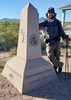
We began our hike at 11:00 am with four adults, one teen and two dogs. The trail path was clear and appeared well traveled. Sadly there was quite a bit of garbage at the beginning, lessening the further along the trail were; clothing, backpacks, food wrappers, water bottles etc. The warnings about the illegal traffic in the area are true. Regardless, the area was gorgeous! The stream bed was running and the waterfalls were flowing as well. there were several deep pools along the route. Deep enough for the dogs to swim! The path was clear and easy to follow for the first 2 miles then we had to start relying on our compasses and rock markers pyramided at corners and bends in the trail. Once you found the markers, the trail was easy enough to pick back up again. The sights and smells were amazing, the pines, the incredible oaks and all the other trees made such a wonderful shaded, cool canopy during the hike. We do believe we were sharing the path with a brown bear or two, we came across countless large piles of fresh bear scat and we even had the pleasure of finding freshly marked trees! It was truly exciting! Along with dozens of different wildflowers the trail was lined with many different types of mushrooms! Dozens to be exact; gold, white, copper red, speckled... They were plentiful and a joy to find! This trail has so much to offer! ** I really recommend head nets the gnats were terrible this time of year. There was no amount of bug spray that would keep them at bay they just attacked your face and eyes. (This was only uncomfortable encounter during the entire trip) The stream bed began to get scarce at about 4.5 to 5 miles into the hike, so if you have pets you may want to bring them an extra bottle of water or two. We hiked during the rainy season and the stream bed was still dry in places along the trail so just take precautionary measures and pack in a bit more water. My daughter and I hiked in with in 2, 50 liter water bottles and it lasted us the duration of the hike. The trail was really overgrown and appeared far less traveled about the 6 to 6.5 mile. The machete was extremely useful to have to cut away the brush, clearing the path. We had been warned about the chiggers being active this time year fortunately, we had no issues them at all. A few of our group did get a tick. But only 2. One at the start of the trail and the other wasn't discovered until we made it to the cabin. Not bad at all! I recommend that everyone do this hike! When you make it out of the tree lines you have the opportunity to see Whipple Observatory across the valley and the mountainous terrain is truly breathtaking! The trail was defined at this point but in several places it was beginning to wash away. It needs some maintenance, or just more hikers :) But it is all passable. It was a refreshing moment coming to the McBeth Spring, the ferns carpeted the mountainside and the massive pines surrounding the spring were breathtaking. The rock basin at the spring was crystal clear and full, the fill pipe was flowing nicely. Three people, including myself drank directly from the spring. The dogs drank too... (no issues at all later) :) The excitement of reaching Josephine Saddle was awesome! We viewed sights we had only seen online to include the Boy Scout memorial. The trail heads at this point are clearly marked. The hike down Old Baldy Trail was a bit rocky but it was nice and wide and more maintained it wasn't until this point during the hike that we came across other hikers on the path. This trail definitely has a lot of hiking traffic. All in all the hike from Patagonia to Madera was absolutely awesome following the routes we had taken all totaling a little over 11 miles. I highly recommend it to everyone! We will be doing this hike again this year. I'd love to see it in the cooler months. I will be bringing high visible markers so I can do my part to help clearly mark the trail as it is unknown if the rock markers will continue to be standing. Our group also mentioned the possibility of a trail clean up mission in the future. The road getting into Temporal Canyon is a bit rough, I would recommend a 4X4 high clearance vehicle or side by side. However, I truly believe a stock Jeep would make it without a problem. We were dropped off at the trail-head which is how I would suggest everyone take this trek. I wouldn't recommend leaving your vehicle here overnight.
 Culture
 Culture [ checklist ]
[ checklist ]  HAZ Rides
wildflower observationwildflower observationwildflower observationwildflower observationwildflower observation
Wildflowers Observation Extreme
There were dozens of different wildflowers along the entire route.

water 1 out of 5water 2 out of 5water 3 out of 5water less than max McBeth Spring Gallon per minute Gallon per minute
The spring was full and flowing steady.
_____________________
  1 archive
Dec 05 2014
avatar

 Photos 88
 Triplogs 338

male
 Joined Feb 10 2012
 Arizona
Temporal Loop, AZ 
Temporal Loop, AZ
 
Backpack avatar Dec 05 2014
whaTriplogs 338
Backpack29.00 Miles 5,500 AEG
Backpack29.00 Miles3 Days         
5,500 ft AEG19 LBS Pack
 no routes
1st trip
A loop backpack in the Santa Rita mountains.

Day 1 - Yesterday the weather report said 20% chance of rain over the next few days. This morning it said 80%. I need more experience in the rain so I didn't cancel my plans.

Started late at the Gardner Canyon trailhead of Temporal Gulch AZT4 and headed south. After a couple miles had lunch and then continued on to Walker Basin where I camped for the night. Lots of litter and TP. A small pool at the base of the dam seemed stagnant, but a short distance up the drainage there was a clear flowing pool. Saw 3 deer, no people today.

Day 2 - Woke to rain at 3am. It went from rain to drizzle and back for the next 12 hours. The first hour or so down the road was fine. Then I started up Temporal Gulch #595. What a miserable several hours. The trail in this section crosses the creek again and again and is hard to follow at times. Some spots are badly eroded, and much of it is overgrown. Most of the time was just a drizzle, but every time I had to push through trees, grass and brush I'd get drenched with a cold bucket of water. Finally I wised up and would whack them with my hiking poles and knock off the worst of it. In nice weather this part would be really interesting along the creek, with many pools and little waterfalls.

Topo maps show a tunnel at Wildcat mine. I thought I'd duck in to get out of the rain for a bit, but I couldn't find anything. Just a large tailing pile, and maybe a buried tunnel above it. After Wildcat the trail was in much better shape. Lots of bear scat though. And I mean lots.

It was only midafternoon but I decided to stop at Josephine saddle and camp. I was rather chilled after being soaking wet for so long. Time to dry off and warm up. Saw no people today.

Day 3 - Backtracked to McBeth Spring for water, then started up the Super Trail around the south side of Wrightson. I kept hearing voices and finally stopped and listened for a while. It was so still and quiet I was hearing workers over on Hopkins.

My original plan was to camp near Baldy Saddle and then hike to the top in the morning. But the short slow day yesterday messed that up. At Gardner Canyon Trail I headed down. The sun finally burned through the overcast and I stopped for lunch on a flat area with a great view to the south and enjoyed the warmth.

At the TH I took the link trail over to the Cave Creek road and followed that back to my car. Finally saw a few people camping in the last couple miles.
_____________________
 
Aug 22 2014
avatar

 Guides 187
 Routes 990
 Photos 12,079
 Triplogs 865

72 male
 Joined Jun 27 2015
 Tucson, Arizona
Temporal Gulch Eastern Half, AZ 
Temporal Gulch Eastern Half, AZ
 
Hiking avatar Aug 22 2014
markthurman53Triplogs 865
Hiking8.00 Miles 1,600 AEG
Hiking8.00 Miles   3 Hrs      2.67 mph
1,600 ft AEG15 LBS Pack
 no routes
1st trip
Linked   linked  
Partners none no partners
This is a round trip hike to finish up the Eastern portion of Temporal Gulch Trail that I wasn't able to finish on a prior hike. The hike started along the Temporal Gulch road out of Patagonia near the Little Joker mine (about a mile from the Temporal Gulch Trail Head). I am always amazed at how green things get after the monsoons, even though I see it every year. Real nice half day hike especially toward the end of monsoons. The drive from Tucson to the trail head probably takes as long as the hike but it is a scenic drive. There is a nice little water fall (cascade) toward the beginning of the trail and the abandon Wildcat mine toward the end (middle of the Temporal Gulch Trail).
_____________________
 
Aug 11 2014
avatar

 Guides 187
 Routes 990
 Photos 12,079
 Triplogs 865

72 male
 Joined Jun 27 2015
 Tucson, Arizona
Old Baldy upper Temporal Gulch Loop, AZ 
Old Baldy upper Temporal Gulch Loop, AZ
 
Hiking avatar Aug 11 2014
markthurman53Triplogs 865
Hiking13.60 Miles 3,275 AEG
Hiking13.60 Miles   7 Hrs   4 Mns   2.41 mph
3,275 ft AEG   1 Hour   25 Mns Break15 LBS Pack
 
1st trip
This was a round trip hike starting at Madera Canyon Old Baldy Trail Head. The route is Old baldy Trail (#372) to Josephine Canyon, Temporal Gulch Trail (#595) to Wild Cat Mine (about 3 miles in) and then return to Josephine saddle and back to start point along the Super Trail (134).

Nice hike for September, Get out of the lower desert heat and there was still water available from summer monsoons. I had never been on the Temporal Gulch Trail so most of the Photos were taken along this trail. I will have to finish up this trail from the other end in lower Temporal Gulch. There are nice views to the South and great close up views of Mount Wrightson from the South. Trail does not seem to used be too much.
_____________________
 
May 31 2014
avatar

 Photos 88
 Triplogs 338

male
 Joined Feb 10 2012
 Arizona
Old Baldy Trail #372 to Wrightson SummitTucson, AZ
Tucson, AZ
Hiking avatar May 31 2014
whaTriplogs 338
Hiking7.20 Miles 2,292 AEG
Hiking7.20 Miles   3 Hrs   42 Mns   2.25 mph
2,292 ft AEG      30 Mns Break
 no routesno photosets
Partners none no partners
Up Old Baldy then out Temporal Gulch to check on McBeth Springs. Still flowing, maybe a pint per minute. Returned via Super Trail.

water 1 out of 5water less than maxwater less than maxwater less than max McBeth Spring Dripping Dripping
Maybe a pint per minute.
_____________________
 
average hiking speed 2.31 mph
1, 2  Next

WARNING! Hiking and outdoor related sports can be dangerous. Be responsible and prepare for the trip. Study the area you are entering and plan accordingly. Dress for the current and unexpected weather changes. Take plenty of water. Never go alone. Make an itinerary with your plan(s), route(s), destination(s) and expected return time. Give your itinerary to trusted family and/or friends.

helpcommentissue

end of page marker