username
X
password
register
for free!
help
ArticlesGuidesRoutes
 
Photosets
 
 Comments
triplogs   photosets   labels comments more
Dome Mountain 3381 - Goldfield Mtns - 23 members in 67 triplogs have rated this an average 3.5 ( 1 to 5 best )
1, 2, 3, 4  Next
67 triplogs
login for filter options
Jan 11 2025
avatar

 Guides 59
 Routes 1,100
 Photos 1,191
 Triplogs 1,290

male
 Joined Jan 01 2023
 Arizona
Dome Mountain 3381 - Goldfield MtnsPhoenix, AZ
Phoenix, AZ
Hiking avatar Jan 11 2025
pseudalpineTriplogs 1,290
Hiking
Hiking
      41 Mns Break
 no routes
1st trip
 Named place
 Named place [ checklist ]
[ checklist ]  Four Peaks  Golden Dome- 3185ft
  3 archives
May 04 2024
avatar

 Guides 3
 Routes 632
 Photos 8,235
 Triplogs 604

54 male
 Joined Apr 13 2011
 Gilbert, AZ
Dome Mountain 3381 - Goldfield MtnsPhoenix, AZ
Phoenix, AZ
Hiking avatar May 04 2024
ddgrunningTriplogs 604
Hiking7.70 Miles 1,588 AEG
Hiking7.70 Miles   3 Hrs   5 Mns   2.61 mph
1,588 ft AEG      8 Mns Break
 
Linked   none no linked trail guides
Partners none no partners
Route Scout Route Recorded  on Route Scout | Pop | Map | Popup | MapDEX
I typed up a triplog, but it didn’t save, and I’m too lazy to redo it. 😄
_____________________
 
Apr 14 2024
avatar

 Guides 1
 Routes 14
 Photos 7,202
 Triplogs 5,208

68 male
 Joined Mar 16 2008
 chandler,az
Dome Mountain 3381 - Goldfield MtnsPhoenix, AZ
Phoenix, AZ
Hiking avatar Apr 14 2024
johnlpTriplogs 5,208
Hiking8.30 Miles 2,280 AEG
Hiking8.30 Miles
2,280 ft AEG
 no routes
Linked   linked  
Partners partners
trekkin_gecko
We set out to hike Dome Mountain, then add on something. We chose Peak 3269. We overshot 3269 and ended up on 3238 first which was fortunate because we spooked a herd of bighorn sheep. Counted nine. There may have been a few more.
We headed back to Peak 3269 before returning to Dome and descending the steep trail.
Kelly loved the sidehill off trail and the steep loose trail to Dome Mountain as well.
Good wildflower display. Foxtail are drying out and will become intolerable soon.
Fun day. Thanks Kelly. :)
 Flora
 Flora [ checklist ]
[ checklist ]  Dudleya
wildflower observationwildflower observationwildflower observationwildflower observationwildflower observation
Wildflowers Observation Moderate
_____________________
“Good people drink good beer.” Hunter S Thompson
 
Apr 14 2024
avatar

 Guides 10
 Routes 673
 Photos 7,281
 Triplogs 4,660

67 female
 Joined Nov 17 2008
 phoenix, az
Dome Mountain 3381 - Goldfield MtnsPhoenix, AZ
Phoenix, AZ
Hiking avatar Apr 14 2024
trekkin_geckoTriplogs 4,660
Hiking8.33 Miles 2,218 AEG
Hiking8.33 Miles
2,218 ft AEG
 no routes
1st trip
Linked   none no linked trail guides
Partners partners
johnlp
the plan for today was to hit dome mountain and then peak 3134 east of the dome saddle
when we got to dome, john wanted to hit 3269
that's been on my wish list, so why not?
dropped down to the west, similar to heading for the camo tanks
then a bushwhack up to 3239
john spotted several bighorn sheep from the summit, which was the highlight of the hike for me
we went across to 3269 and checked out the views
had we used our approach for 3239 to hit 3269, then stayed high to 3239, we would have eliminated a lot of side hill on loose rock
then needed to follow our original approach on the return
between the peaks was not that difficult
we went back up to dome, then down to the saddle
nice to get a new set of peaks
3239 is a dramatic landmark, plus the sheep
want to hit 3134 and panorama again sometime
think the window for any off trail in the goldfields is closing
glad we changed plans, although this type of hiking is hard for me and i'm slow
good temps
a few off road vehicles on our way out
thanks john, good times :)
_____________________
hazhole
  1 archive
Apr 04 2024
avatar

 Guides 104
 Routes 256
 Photos 16,118
 Triplogs 528

53 male
 Joined Dec 30 2005
 Tucson, AZ
Dome Mountain 3381 - Goldfield MtnsPhoenix, AZ
Phoenix, AZ
Hiking avatar Apr 04 2024
Mike_WTriplogs 528
Hiking4.64 Miles 1,303 AEG
Hiking4.64 Miles   3 Hrs      1.55 mph
1,303 ft AEG
 
1st trip
Linked   none no linked trail guides
Partners none no partners
Note: This hike was not a bushwhack at all! The hike involves road and good trail all the way to the summit.

I camped the night before about 1.4 miles East of Usery Pass not far from FS 3554 after hiking Usery BM, a few numbered peaks and Pass Mt. It was a full day of hiking and this was the 3rd day of my trip. I got up early, had a big bowl of oatmeal and hot chocolate in the morning. I packed up my campsite and drove over to the Wolverine gate. I had access to the Bulldog canyon so I decided to drive in a bit, down FS 10, and after roughly 0.3 miles, I turned right on FS 1356. This road is strictly 4x4 and there were a few rough spots but I made it in my capable Chevy 4x4 truck.

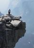
After driving a total of about 1.2 miles from the gate I saw a few other vehicles parked here. I parked and started my hike from this point at around 9 am. The weather was nice at this time but it was warming up quick. I followed an unmarked road Northwest and then North for about 1 mile before I found a trail leading off to the right. This is the trail to take to get to Dome Mt. The trail leads up to a saddle. From there, you will need to make a left and head up along some cliffs and up to the top.

Along the way, I saw a wide variety of wild flowers and plants - some orange globe mallow, brittlebush, poppies, cholla, wolfberry, red salvia or firecracker bush, New Mexico plumeseed, cream cups, chalk dudleya, miner's lettuce, rockcress, saxifrage-pink, lanceleaf liveforever, Eaton's penstemon (red), Florida hopbush, bachelor's button, indian paintbrush, red-maids, purple sandwort, Coulter's lupine, and more.

Past the first saddle, on the way up, I saw a solo hiker coming down and 2 large groups coming down when I was 750 feet from the summit. Overall the trail was good but there were a few gravelly slippery areas and I needed to take my time in these sections.

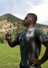
At the summit, I found an ammo box with a registry which I signed. There were some amazing views all around.

Stats:
--------
Distance (round trip) = 4.64 miles
AEG = 1303 feet
Strava moving time = 2 hrs 22 mins
Strava elapsed time = 3 hrs 57 mins
wildflower observationwildflower observationwildflower observationwildflower observationwildflower observation
Wildflowers Observation Substantial
Along the way, I saw a wide variety of wild flowers and plants - some orange globe mallow, brittlebush, poppies, cholla, wolfberry, red salvia or firecracker bush, New Mexico plumeseed, cream cups, chalk dudleya, miner's lettuce, rockcress, saxifrage-pink, lanceleaf liveforever, Eaton's penstemon (red), Florida hopbush, bachelor's button, indian paintbrush, red-maids, purple sandwort, Coulter's lupine, and more.
_____________________
Michael Williams
IT Professional
Rocky Point Vacation Rentals
Ocean Front Condo in Rocky Point, Sonora, Mexico
www.beachfrontmexico.us
Image
  2 archives
Feb 01 2024
avatar

 Guides 99
 Routes 1,484
 Photos 16,072
 Triplogs 1,374

male
 Joined Jan 07 2017
 Fountain Hills,
Dome Mountain 3381 - Goldfield MtnsPhoenix, AZ
Phoenix, AZ
Hiking avatar Feb 01 2024
DixieFlyerTriplogs 1,374
Hiking6.86 Miles 1,760 AEG
Hiking6.86 Miles   4 Hrs   14 Mns   1.93 mph
1,760 ft AEG      41 Mns Break
 
1st trip
Linked   none no linked trail guides
Partners partners
SecretMtnLover
Route Scout Route Recorded  on Route Scout | Pop | Map | Popup | MapDEX
I had not hiked up to Dome Mountain in 3 years, so I decided to go out there today. On the way back we checked out Elliptical Arch. I had seen the arch before from a distance, but never climbed into it until today.

I parked at the Bulldog Canyon Wolverine Gate. In years past, I would get a pass and drive closer to where I wanted to hike. They have now raised the fees for a pass, and it didn't seem worth it to get a pass for just going there one time. On the plus side, raising the fees seems to have sent the squatters elsewhere.

The trail up to Dome Mountain is much more defined than in years past, and is now easy to follow. That makes the painted lines and cairns along the route totally unnecessary.

The hike up to the summit seemed steeper than I remembered it. The views at the top are still really, really nice though.

We stopped by the arch on the way back, and it was a fun scramble to get up inside the arch.

It was a nice little hike and was a nice day to be out in the Goldfields!
 Geology
 Geology [ checklist ]
[ checklist ]  Natural Arch
 Culture
 Culture [ checklist ]
[ checklist ]  Intrepid Back Shot
_____________________
Civilization is a nice place to visit but I wouldn't want to live there
 
Jan 19 2024
avatar

 Photos 16
 Triplogs 19

female
 Joined Jan 08 2020
 
Dome Mountain 3381 - Goldfield MtnsPhoenix, AZ
Phoenix, AZ
Hiking avatar Jan 19 2024
Hiker_EmTriplogs 19
Hiking6.35 Miles 1,465 AEG
Hiking6.35 Miles
1,465 ft AEG
 no routesno photosets
1st trip
Linked   none no linked trail guides
Partners none no partners
Fun, short hike. Perfect weather for exploring! I was pleasantly surprised that the trail was obvious in most areas. I enjoyed the moody skies for some photography and then hit up another area on the way out for some exploring.
 
Jan 08 2024
avatar

 Guides 110
 Routes 2,246
 Photos 8,982
 Triplogs 2,600

45 female
 Joined Dec 24 2007
 Ahwatukee, AZ
Dome Mountain 3381 - Goldfield MtnsPhoenix, AZ
Phoenix, AZ
Hiking avatar Jan 08 2024
LindaAnnTriplogs 2,600
Hiking8.39 Miles 1,711 AEG
Hiking8.39 Miles   4 Hrs   22 Mns   2.14 mph
1,711 ft AEG      27 Mns Break
 
Linked   linked  
Partners none no partners
Route Scout Route Recorded  on Route Scout | Pop | Map | Popup | MapDEX
Jill and I opted for Dome Mtn in the Goldfields this morning. Parked at the Wolverine gate, where the parking area was full of vehicles and hikers. Luckily most were headed over to Blue Ridge, so we quickly escaped their chatter.

Walked up the road, then up the trail. The road was frozen on the ascent, so no mud, but had later thawed, so our return was messier. Cool temps, but no breeze, so we shed a layer at the saddle. Slower hike after the saddle, but that’s the fun part. Noticed some small patches of snow/graupel in the shady sections. There was a group of 7 or 8 hikers at the summit. We said our hellos then sat down at the east end of the summit for a break. Great views of the snow over on Four Peaks and the Supes.

Started our descent shortly after the group left, but noticed one of them had left a pack behind. Grabbed it and tried to catch up with them. Got the pack returned before the guy had to walk too far back uphill to retrieve it. After that, an uneventful hike back down, then headed over to Blue Ridge. Didn’t spend too long over there since Jill was wanting to be done by around 1300. We finished a minute after the promised time. Nice day, with almost perfect weather.
 Named place
 Named place [ checklist ]
[ checklist ]  Four Peaks Wilderness
_____________________
Stop crying and just go do the hike.
 
Mar 05 2023
avatar

 Guides 110
 Routes 2,246
 Photos 8,982
 Triplogs 2,600

45 female
 Joined Dec 24 2007
 Ahwatukee, AZ
Goldfields sampler, AZ 
Goldfields sampler, AZ
 
Hiking avatar Mar 05 2023
LindaAnnTriplogs 2,600
Hiking12.46 Miles 3,009 AEG
Hiking12.46 Miles   9 Hrs   2 Mns   1.76 mph
3,009 ft AEG   1 Hour   57 Mns Break
 
1st trip
Route Scout Route Recorded  on Route Scout | Pop | Map | Popup | MapDEX
Put together sort of a random loop for today, with options to make adjustments. Jason and I got started from the Wolverine Gate at 0600. Cool to start, but no breeze made it nice. Lights for the first 20 minutes or so. The road walk is boring, but went by quickly. The sun rose as we left the road and took the trail up to the saddle.

From there, we headed over to Dome Mountain first, getting the highest peak of the day out of the way. Careful descent, the over to Peak 3134 on the Three Lesser Peaks route. After a break up there, we dropped off the south-southeast side of the peak and steeply descended to the southeast. Once over to a rocky ridge, the footing got much better, and we made our way to 3089. Great views from up there. Another descent, off the northeast side this time, and ascent up to 3047.

Came off the east side of that peak, to the saddle, then north down the drainage, which had some water. We stayed just on the east bank as we made our way down, then traversed east over towards the next big wash. The offtrail was slow, but not terrible. Original plan was to take the wash south, but we switched gears and headed southeast on Horse With No Name. This was a good choice, as the section we took was a lot of fun and had great views.

Dropped down into Cottonwood Wash, then south. Headed west on the road (Rock House trail), then south to Blue Ridge. Looked around there, then walked back to the parking lot. Great day & weather. Not too much traffic on the roads out there, and only saw a few hikers in the final mile or so. Good to hike with Jason again.
wildflower observationwildflower observationwildflower observationwildflower observationwildflower observation
Wildflowers Observation Substantial
Lots of flowers along nearly the entire route.

water 1 out of 5water less than maxwater less than maxwater less than max Cottonwood Spring Dripping Dripping
Spring and springbox were full of water.
_____________________
Stop crying and just go do the hike.
 
Mar 05 2023
avatar

 Routes 31
 Photos 4,724
 Triplogs 187

50 male
 Joined Mar 14 2016
 Gold Canyon, AZ
Dome Mountain 3381 - Goldfield MtnsPhoenix, AZ
Phoenix, AZ
Hiking avatar Mar 05 2023
00blackoutTriplogs 187
Hiking12.60 Miles 3,009 AEG
Hiking12.60 Miles
3,009 ft AEG
 no routes
1st trip
Partners partners
LindaAnn
It had been a little bit since Linda Ann and I had hiked together and years since I had been in the Goldfields, so she put together a nice 'flat' route for us yesterday. Started at the Bulldog Canyon Gate at 6am and hiked up the road for the initial part which was blah but was pretty quick. Then took the connector up to Dome Mountain. The trail started ascending gradually but got pretty steep the closer to the summit, but overall was in really great shape. Spent a few minutes on top of Dome, signed the register and headed back down to meetup with the connector that would take us up to peak 3134. Again, the there was a decently defined trail here along with cairns which made the going much easier. Found another register on top and after a few minutes we begin making our way over to 3089. This is where the trail ended; started with a steep bushwhack down to a saddle then up to peak 3089. From there the bushwhack continued down to a wash then a short bur fairly steep climb up to 3047. The views from all four of the peaks and the entire ridgeline were fantastic, well worth the effort. From the top of 3089 it was a slow bushwhack down and over to the Horse with No Name trail. Our original goal was to hike up to Top Hat, however, once we saw the Horse with No Name trail making it's way up a rock face we changed things up. Up and back down the Horse with No Name trail then over to Packsaddle with a quick stop at Cottonwood Spring, which was a cool setup. Continued on to the Rock House trail then over and up Blue Ridge before finally heading back to the TH. Finished with 12.6 miles with just over 3,000 AEG for the day hitting 4 peaks. Weather was a bit chilly to start, got a bit warm mid day but the wind and high clouds helped to keep the temps down. Thanks Linda for putting together this awesome route, there is definitely some additional hiking I want to do in the Goldfields.
 Culture
 Culture [ checklist ]
[ checklist ]  HAZ - Hike HAZard
wildflower observationwildflower observationwildflower observationwildflower observationwildflower observation
Wildflowers Observation Light
_____________________
Hiking is just walking where it’s okay to pee. :y:
 
Jan 06 2023
avatar

 Photos 99
 Triplogs 872

male
 Joined Mar 18 2012
 Goodyear, AZ
Dome Mountain 3381 - Goldfield MtnsPhoenix, AZ
Phoenix, AZ
Hiking avatar Jan 06 2023
MikeSTriplogs 872
Hiking6.70 Miles 1,502 AEG
Hiking6.70 Miles   2 Hrs   53 Mns   2.32 mph
1,502 ft AEG
 no routesno photosets
1st trip
Linked   none no linked trail guides
Partners none no partners
This is a great remote hike, first 2 miles on jeep trail but once you get off it, it is such a great one. Last half mile is straight up.
_____________________
Subscribe to my adventure videos at: [ youtube video ]

Follow my adventures on Instagram at: adventures_az
 
Apr 09 2022
avatar

 Guides 25
 Routes 376
 Photos 5,897
 Triplogs 346

40 male
 Joined Mar 01 2018
 Chandler, AZ
Dome Mtn - 3 Lesser Peaks - Elliptical Arch, AZ 
Dome Mtn - 3 Lesser Peaks - Elliptical Arch, AZ
 
Hiking avatar Apr 09 2022
John10sTriplogs 346
Hiking10.21 Miles 2,475 AEG
Hiking10.21 Miles   8 Hrs   29 Mns   1.90 mph
2,475 ft AEG   3 Hrs   6 Mns Break
1st trip
We only had time for something shorter today, so we decided to return to the Goldfields and finish off a hike that we didn't quite complete in early January, on another day when we were short on time. That day, we hiked to Dome Mountain and two of the Three Lesser Peaks before we needed to turn back. The plan today was to change it up and hike the full loop counter-clockwise, following a 2019 route by @mr_squishy, and also look for Elliptical Arch, which we didn't find in January.

The parking lot at Bulldog Canyon Gate was empty when we arrived just after sunrise, and it was in the mid-60s when we got on the trail and headed toward Blue Ridge. The first few miles were a combination of trails, roads, and some easy off-trail hiking in washes before we reconnected with trails/roads again. West of Top Hat, we followed part of the Twin Arches route before branching off for the climb up to the saddle between the two eastern Lesser Peaks.

We hiked the peaks east-to-west and started with Peak 3047, the one we didn't have time to reach in January. It's an easy hike to the top, and there was a wooden (SOTA?) post at the summit. Next up was Peak 3089, and the eastern side of the peak was covered with beautiful orange flowers, which looked great among the other yellow wildflowers and the many cacti and ocotillo blooms.

At the summit, I was curious to see if anyone had signed the register I placed in January. They hadn't...I guess that peak doesn't get much traffic, or the jar was a little too hidden. Regardless, I was also the second person to sign my register :). From there, we followed the ridge over to Peak 3134, and that register had quite a few names added since we were last there...that one is obviously the most popular of the three. I considered going over to the other low peak NE of 3134, the unofficial fourth Lesser Peak (Least Peak?), but it didn't look like there was much to see over there.

We had some time to spare when we came down to the saddle northwest of 3134, so I made a quick out-and-back up to Dome Mountain and signed the register. The 1982 Girl's Tennis statue/trophy that was up there in January was still there, but both arms were broken off and sitting nearby. The summit register was full and the cover had separated from the pages...things have deteriorated up there in the past few months.

I returned to the saddle, and we headed into the beautiful area with the yellow rock west of Peak 3134. I'd done a little more research on the location of Elliptical Arch, and it paid off--we left the trail and found it pretty quickly. All the pictures I'd seen were taken from a distance, and I was pleasantly surprised to find that it was easy to get over there and see it up close...unlike so much of the Goldfields, it wasn't the typical crumbly, loose rock leading up to the arch.

[ youtube video ]

We didn't see any hikers all day, just some ATV in traffic in the last mile on the way back to the trailhead, and the parking lot was still empty when we finished. Not much mileage today, but it was nice to come back and complete the full loop and find Elliptical Arch on a much warmer day.
 Geology
 Geology [ checklist ]
[ checklist ]  Natural Arch
 
Jan 29 2022
avatar

 Guides 264
 Routes 2,797
 Photos 14,494
 Triplogs 5,894

55 male
 Joined Nov 20 1996
 
Windy Dome Bushwhack Loop, AZ 
Windy Dome Bushwhack Loop, AZ
 
Hiking avatar Jan 29 2022
joebartelsTriplogs 5,894
Hiking12.29 Miles 3,110 AEG
Hiking12.29 Miles   8 Hrs   4 Mns   1.75 mph
3,110 ft AEG   1 Hour   2 Mns Break
 
1st trip
Partners partners
The_Eagle
wallyfrack
Route Scout Route Recorded  on Route Scout | Pop | Map | Popup | MapDEX
My heart wasn't in this from the get-go. Traveling across the entire valley to Usery or the Goldfields is stopping short of hikes I prefer. Nobody likes bushwhacking and the wind is my nemesis. On the bright side, a different pair of wind goggles worked much better than what I'd been using.

This was my first visit to the Bulldog vicinity so it was good to finally see where throngs of valley hikers explore. It was my assumption the area was a trashed wasteland. Everything I saw was leaps and bounds better than anticipated.

We hiked FR10 to the westside of the Dome peaks with a mini foray into Bulldog Canyon along the way to cutout road walk. The twin Dome mountains never caught my attention being just a half-mile apart. It makes sense though, the north is in Stewart Mtn topo and the south is in Apache Junction topo.

We hiked Satan's Windtunnel Backyard to the saddle between the peaks. Skipped the south/3269/3239 and headed for the north/3381. The route is well cairned and we were on top much quicker than anticipated (from the saddle). I'm sure it's great and all but I just wanted to leave.

When all seemed hopeless, we dropped down to the guzzler. Out of the wind, it seemed odd this might be the highlight of the day but boy was I happy to travel with full vision. Then up to a saddle for lunch with a crow serenading. After lunch, the pace finally picked up roller coastering mini high points of a ridge. Kinna like highjacking a preschool edition to the motherlode (at warp speed, the peaks are maybe 50 ft tall... lol).

Somebody suggested cutting down and over. Like any ignorant wide-eyed group of fools, we agreed in unison to give it a go. Now into the flipside of Satan's Backyard and sick on the poisoned lure with the stupidity of real men don't backtrack, Bruce sold it as a tibber track so we forged onward.

With another option to change the course we wearily voted on another shortcut. After a short break to pray for forgiving terrain, we gave it a go. Luck finally kicked in and it was a freeway route to the Official Route.
_____________________
- joe
 
Jan 29 2022
avatar

 Guides 41
 Routes 1,626
 Photos 14,983
 Triplogs 2,760

69 male
 Joined Jan 20 2009
 Far NE Phoenix,
Windy Dome Bushwhack Loop, AZ 
Windy Dome Bushwhack Loop, AZ
 
Hiking avatar Jan 29 2022
The_EagleTriplogs 2,760
Hiking12.69 Miles 3,005 AEG
Hiking12.69 Miles   8 Hrs   4 Mns   1.82 mph
3,005 ft AEG   1 Hour   6 Mns Break14 LBS Pack
 
1st trip
Route Scout Route Recorded  on Route Scout | Pop | Map | Popup | MapDEX
I like to try new things, and I have not spent much time in the Goldfields. I know that Joe prefers traveling across the valley to do the Goldfields over he Supes, loves bushwhacking and give him a high wind condition, and he is as happy as a clam. Who am I to deny him all this. Wally joined us and Denny was a now show because he was hitting up the Night Club and beach scene in Miami for the weekend.

I cobbled together a bunch of tracks to take us on a tour of the Goldfields including both Dome Mountains.

We walked through the unlocked and open gate around 7:30 and immediately talked to a hiker who said he was just returning from hiking to Dome Mountain. Joe got all excited when he commented at how windy it was.

FR10 was a nice way to warm up the joints for the climb later. We passed a few people camping but only one Jeep on the move. We hit up a minor cave and a couple of small arches before making our climb up the drainage up the west side to the saddle of the Domes. It's a steady climb, lots-o-bolder hopping and prickly stuff to avoid. It's very slow going. Joe was happy as a clam all the way up. I think he sang every Disney song in the catalog.

Up at the saddle, we took a break out of the wind and contemplated our next move. We ditched the idea of climbing to the lower Dome Mountain. It was into the strong wind. We were afraid that Joe would go all Sally Fields on us, turning into the Flying Nun and whisk his way off the mountain.

We hit up Dome 3381 to the north before retreating down to the Tiki Bar guzzler called Goldfield Two.

After lunch and Joe's conversation with a crow, we started the ridgeline portion of this hike. This was much better (and easier) than expected.

Now we got to the part that got Joe most excited. We got to a point where we decided to take a shortcut. Joe needed to get home for his Saturday afternoon waxing. (I did not ask) We cut down a canyon that was easy peazy to begin with. It got thicker, steeper, pokier and rockier. I've never seen Joe happier.

At the bottom of the canyon he wanted to stretch the hike info some thing longer, but Wally and I talked him out of it.

We finally hit some nice trails the roads for the return to the TH. The Goldfields really have some excellent views and options. I would not be surprised if this was the new daily Piestewa hike for him.
 Fauna
 Fauna [ checklist ]
[ checklist ]  Millipede
_____________________
There is a very fine line between "hobby" and "mental illness."
Dave Barry 🦅
  2 archives
Jan 29 2022
avatar

 Routes 93
 Photos 7,758
 Triplogs 1,691

64 male
 Joined Mar 11 2003
 AZ
Windy Dome Bushwhack Loop, AZ 
Windy Dome Bushwhack Loop, AZ
 
Hiking avatar Jan 29 2022
wallyfrackTriplogs 1,691
Hiking12.29 Miles 3,110 AEG
Hiking12.29 Miles   8 Hrs   4 Mns   1.75 mph
3,110 ft AEG   1 Hour   2 Mns Break
 no routes
1st trip
Partners partners
joebartels
The_Eagle
I was loving the Goldfields until I wasn't. :o The start was a cool 51 degrees with the wind blowing away. The road hiking was easy and the first wash was choked but relatively easy to navigate. The wash up to the saddle was ugly and the traverse up to on ball bearing gravel into the wind tunnel was down right annoying. The cairned route up to Dome Mountain with the wind at our backs was a welcome relief. The guzzler was an interesting distraction and the lunch spot top notch. The ridgeline over to the high point of the hike was well the high point and it went down hill from there. Even the wildlife wasn't anywhere to be found in the thicket. For a while I was thinking this should have been called the Dumb Dumb route but I fell for it. :doh: We were glad to finally find the trail and it was easy going back. There was good and bad. It was nice to get out with Joe & Bruce and I got to see more of The Goldfields. In the end I'm glad I hiked this route and I'm equally glad it's over.
_____________________
  1 archive
Jan 26 2022
avatar

 Guides 187
 Routes 989
 Photos 12,068
 Triplogs 864

72 male
 Joined Jun 27 2015
 Tucson, Arizona
Dome Mountain, AZ 
Dome Mountain, AZ
 
Hiking avatar Jan 26 2022
markthurman53Triplogs 864
Hiking7.43 Miles 1,267 AEG
Hiking7.43 Miles   4 Hrs   57 Mns   1.65 mph
1,267 ft AEG      27 Mns Break
 
Linked   linked  
Partners partners
mamakatt22
Hiked up to Dome Mountain from Bulldog Trail Head. A couple years ago I attempted hiking up via the east slope to the saddle south of Dome Mountain, that was a nightmare. I headed back down not making it to Dome Mountain. I have since heard there was a route to Dome Mountain along the East Ridge and went that route on this hike. Nice route, easy to follow. May be easy to follow but it is steep. My plan was to do the loop that passes over Dome Mountain then head north along the ridge and back to the saddle east of Dome Mountain. I am not sure of the route from Dome Mountain north and east, all I had was a GPS route. Not sure weather this would be a hard bush whack or a route similar to the route up to dome. I was having second thoughts of dragging Ginny through this without knowing what I was getting into. I was even questioning getting her this far (she actually did really well, only fell once on the way down on the roller bearing rocks). My plan was to not hit dome summit but skirt around it just below the summit. When we got just below the summit we opted to not do the rest of the hike and return the way we came (it was noon). This decision was not totally because of Ginny, I was pretty pooped. To many flat lander hikes in Texas I guess or maybe I'm just getting old, I'm going with the former.

The views from this trail are fantastic from the get go at Bulldog Trail Head. Very colorful yellow lichen on the rocks on the way up to the saddle. Red and white arrows marking the already fairly obvious route are pretty faded now and won't be long before they area bad distant memory. Today was really clear and four Peaks showed up crisp and clear.
_____________________
 
Jan 06 2022
avatar

 Guides 110
 Routes 2,246
 Photos 8,982
 Triplogs 2,600

45 female
 Joined Dec 24 2007
 Ahwatukee, AZ
Dome Mountain 3381 - Goldfield MtnsPhoenix, AZ
Phoenix, AZ
Hiking avatar Jan 06 2022
LindaAnnTriplogs 2,600
Hiking9.30 Miles 2,298 AEG
Hiking9.30 Miles   5 Hrs   5 Mns   1.94 mph
2,298 ft AEG      18 Mns Break
 
Partners none no partners
Route Scout Route Recorded  on Route Scout | Pop | Map | Popup | MapDEX
Got started a little later than I would have liked, but temps were still okay. In an effort to avoid some of the road walk, shortly after starting, I veered west and followed some lesser used roads and a horse trail north for a while. Worth the effort? Debatable. It certainly wasn’t any faster, but it kept me off the road.

Continuing north, I headed uphill and up to the saddle. That section of trail is fun, and I like walking through and across the rocks. At the saddle, I turned left and made my way up to Dome Mtn. Going a few days after rain is nice—the rocks are dry, but the dirt is still slightly softer, giving better traction. The higher you go, the steeper it gets. Lots of loose rock just below the summit, which is more noticeable on the descent.

After a quick break at the summit, I carefully made my way back down. The rocks are grippy, but it was still nice to be in a newer pair of shoes with good tread. At the saddle, I headed over to 3134. Plenty of cairns to follow. I wished I had brought some clippers since some of the palo verde is encroaching on the trail. Ten or fifteen minutes of work would have spared me some scratches. Took another break at the summit, then headed back down.

Once back down to the road, I headed east and then south towards Blue Ridge, borrowing one of @tibber ‘s recent tracks. Neat area, with some cool rocks. Noticed an alcove below, which I headed over to after I had made my descent. Easy enough to get to the alcove, but it was full of bees, so I took a few pics and made a hasty retreat. From there, it was a quick walk back to the trailhead.

A little warmer than I would prefer, and no breeze, but still a nice day.

dry Bulldog Canyon Wash Dry Dry
Dry
_____________________
Stop crying and just go do the hike.
 
Jan 02 2022
avatar

 Guides 25
 Routes 376
 Photos 5,897
 Triplogs 346

40 male
 Joined Mar 01 2018
 Chandler, AZ
Dome Mountain and Two Lesser Peaks, AZ 
Dome Mountain and Two Lesser Peaks, AZ
 
Hiking avatar Jan 02 2022
John10sTriplogs 346
Hiking9.04 Miles 2,386 AEG
Hiking9.04 Miles   7 Hrs   28 Mns   1.62 mph
2,386 ft AEG   1 Hour   54 Mns Break
 
1st trip
Route Scout Route Recorded  on Route Scout | Pop | Map | Popup | MapDEX
On our first hike of 2022, we headed back to the Goldfields for the third time in the past few weeks. The plan for today was to hike up to Dome Mountain and Three Lesser Peaks, and hopefully see Elliptical Arch on the way. We started from Bulldog Canyon Gate at sunrise, and it was a cold morning, with a layer of ice on the puddles. The views of the peaks were beautiful as the sun came up and we started hiking along FR 10 and FR 1356.

I'd only previously hiked up to Dome Mountain from the back (north) side, so this was my first time approaching from the south on the "official" route. The stretch between FR 1356 and the saddle is a great area among all the yellow cliffs, though some idiot spray-painted red arrows to mark what was already an obvious route...there seems to be a lot of that in the Goldfields. I'd marked a waypoint where I thought Elliptical Arch was located and explored a little off the trail but didn't find it. We did find some small windows in the rock, but not the arch. On our way up to the saddle, we had to go up around some smooth rock slopes that were covered in ice.

When we reached the saddle, we took a left up toward Dome Mountain. It's a short (~0.5 mile) and fairly steep route up to the summit, but much easier than the approach I took last time from the other side. This stretch had a series of white paint streaks marking the route...not as visually intrusive as the red arrows, but still annoying. One other hiker got up to the top around the same time we did, and the wind chill was very cold--the temperature was in the 40s, and the wind must have been gusting 25-30 mph at the top, so we had an incentive to keep moving and not linger at the top too long.

Near the summit cairn, there was a small statue/figure of a cartoonish tennis player, and the base said, "Girls Tennis 1982"...an odd thing to find at a summit. I found my previous entry in the summit register from September. My friend and I hiked to Dome Mountain and Peaks 3269 and 3239 that day, and it was 100°+ and very humid, and he ended up with bad leg cramps. His entry in the register, which I hadn't read until today, started with "Inhospitable conditions..." Today, we had the opposite problem with the frigid wind chills--what a difference four months makes :).

We headed back down toward the saddle and passed two people and a dog making their way up, and they were cursing the inaccuracy of AllTrails as they passed :). We hiked up to Peak 3134 next, and the trail was well established and had plenty of cairns marking the way. We signed the summit register and took a quick break at the top. There were plenty of familiar HAZ names in the register--more there than in the Dome Mountain register.

[ youtube video ]

With the amount of time we had today, we'd talked about making it an out-and-back and hiking to the two other Lesser Peaks another day, but it looked like a fast hike to get over to Peak 3089, so I decided to make a quick detour over there. It was a short but steep scramble off the peak on the southeast side of 3134 but easy hiking along the ridgeline after that. TBoneKathy waited on 3134, and it took me ~10 minutes to get over to Peak 3089. There was no summit register there, but I had an empty plastic bottle with me and placed one at the peak...I'd forgotten to bring an extra writing utensil to leave behind, so it's a BYOP register :).

[ youtube video ]

Getting over to the third peak, 3047, looked straightforward, but I headed back for the hike out since we didn't have too much time today....though, in hindsight, I should have just gone over there--it probably would have only added another 20 minutes getting there and back. But we started down from 3134 to the saddle and hiked out the same way we came in. We still didn't see Elliptical Arch on the way back but had plenty of great views of the Superstitions. The wind had calmed down, and it turned into a nice day, and it was a solid start to the year even if we didn't hike the full loop or find Elliptical Arch today.
 Meteorology
 Meteorology [ checklist ]
[ checklist ]  Sunrise

water 1 out of 5water less than maxwater less than maxwater less than max Bulldog Canyon Wash Pools to trickle Pools to trickle
water report recorded in the field on our app Route Scout Small puddles
  3 archives
Nov 26 2021
avatar

 Guides 27
 Routes 669
 Photos 12,096
 Triplogs 856

56 male
 Joined Jul 05 2006
 Mesa, AZ
Dome Mountain 3381 - Goldfield MtnsPhoenix, AZ
Phoenix, AZ
Hiking avatar Nov 26 2021
DarthStillerTriplogs 856
Hiking6.76 Miles 1,299 AEG
Hiking6.76 Miles   3 Hrs   55 Mns   1.79 mph
1,299 ft AEG      8 Mns Break
 
Linked   none no linked trail guides
Partners none no partners
We decided to do a hike the day after Thanksgiving with our friends. I thought it would be a nice idea to try something a little more challenging than just a mostly level hike, but wasn't too hard to do or took all day. Dome Mountain fit the bill on those items, and it's very close to home as well.

We missed the turn off the road because I was trying keep up with the two older boys who were way ahead of everyone. We got on the singletrack and headed up. It was slow going the further we got and the steeper the terrain got. We still made steady progress until we got just below the peak where the trail goes right next to an exposed cliff and then heads up a very steep part next to that cliff. It really isn't too bad or very exposed, but i think the difficulty of the trail to that point had set in some fatigue, and no one was comfortable going any further. I didn't want to press the issue to make anyone feel uncomfortable, so we headed back down after a break. I was nearly 11am by that point anyway, and lunch time would be soon.

On the way down, Natasha slipped at point and twister her ankle, but was ok after a bit. She was sore later that night but ok the next day, nothing serious. Got nearly 7 miles in for the day and nearly 1500' AEG, so it was a decent hike for having the kids along.
_____________________
 
Nov 16 2021
avatar

 Routes 215
 Photos 1,337
 Triplogs 124

53 male
 Joined May 26 2017
 Phoenix, AZ
Dome Mountain and Peak 3125, AZ 
Dome Mountain and Peak 3125, AZ
 
Hiking avatar Nov 16 2021
Nate_FTriplogs 124
Hiking7.82 Miles 2,032 AEG
Hiking7.82 Miles   4 Hrs   31 Mns   2.01 mph
2,032 ft AEG      37 Mns Break
 
1st trip
Partners none no partners
Hiked in the beautiful Goldfields this morning. A good track from Hike Arizona kept me on the right path and I also visited
a nearby Eastern peak from the saddle, I measured other peak at 3125 feet, according to Garmin. A little overgrown in places, but cairned well. Enjoyable day! I'll have to take the loop around next time! :)
_____________________
  1 archive
average hiking speed 1.9 mph
1, 2, 3, 4  Next

WARNING! Hiking and outdoor related sports can be dangerous. Be responsible and prepare for the trip. Study the area you are entering and plan accordingly. Dress for the current and unexpected weather changes. Take plenty of water. Never go alone. Make an itinerary with your plan(s), route(s), destination(s) and expected return time. Give your itinerary to trusted family and/or friends.

helpcommentissue

end of page marker