username
X
password
register
for free!
help
ArticlesGuidesRoutes
 
Photosets
 
 Comments
triplogs   photosets   labels comments more
Horseshoe Trail - MSP - 9 members in 82 triplogs have rated this an average 2.3 ( 1 to 5 best )
1, 2, 3, 4, 5  Next
82 triplogs
login for filter options
Sep 22 2023
avatar

 Guides 59
 Routes 1,100
 Photos 1,191
 Triplogs 1,290

male
 Joined Jan 01 2023
 Arizona
Tom's Thumb Loop off Windgate Pass TrailPhoenix, AZ
Phoenix, AZ
Hiking avatar Sep 22 2023
pseudalpineTriplogs 1,290
Hiking13.91 Miles 3,224 AEG
Hiking13.91 Miles   4 Hrs   38 Mns   3.14 mph
3,224 ft AEG      12 Mns Break
 
1st trip
Route Scout Route Recorded  on Route Scout | Pop | Map | Popup | MapDEX
  2 archives
Jan 16 2023
avatar

 Guides 4
 Routes 491
 Photos 10,890
 Triplogs 1,257

55 male
 Joined Nov 20 2012
 Phoenix, AZ
Desert Park Gateway Loop, AZ 
Desert Park Gateway Loop, AZ
 
Hiking avatar Jan 16 2023
BiFrostTriplogs 1,257
Hiking7.37 Miles 921 AEG
Hiking7.37 Miles   2 Hrs   48 Mns   2.63 mph
921 ft AEG
 
Partners partners
John9L
slowandsteady
We decided to trudge through some rain to hike in the desert. Of course, with the rain it really cut down the crowds even on a holiday. Started out on the Horseshoe trail from the parking lot just off Legacy but it’s relatively close to Gateway.

Then onto the Desert Park Trail following that into the preserve. The rain pretty much held off with just some light drizzle and a low cloud deck. Eventually we reached the Windgate Pass and Gateway junction. At this point we had only seen a couple of people so that was nice. That changed a bit once we arrived at the Gateway Loop junction. It also started to rain harder which was in the forecast anyway.

Around the loop the hard rain continued but still not many people. Finished the Gateway Loop and back to the Horseshoe Trail to finish up the hike. With all the rain everything was lush and green. After all the hiking in the desert I’m still amazed how a few good rains can make it all so green!!
_____________________
  1 archive
Mar 20 2022
avatar

 Routes 17
 Photos 2,773
 Triplogs 249

53 female
 Joined May 15 2009
 Phoenix and Tucs
Micky D Loop, AZ 
Micky D Loop, AZ
 
Hiking avatar Mar 20 2022
cindylTriplogs 249
Hiking13.61 Miles 3,148 AEG
Hiking13.61 Miles   7 Hrs   18 Mns   2.01 mph
3,148 ft AEG      31 Mns Break
 
no photosets
1st trip
Route Scout Route Recorded  on Route Scout | Pop | Map | Popup | MapDEX
i was thinking that i would rate each trail by the number of people i saw on the trail until i got to the last trail (desert park trail), where i didn't see anyone but it was surrounded by views of people's backyards. i had the most fun coming down out of windgate pass and back up the east end trail. i took my break up at the lookout with just one other person, and i also really enjoyed coming down the tom thumb trail in the rain. oh yes, the rain was so sweet.

side note: i had trouble with route scout losing me again for nearly all of the east end trail, and then although i was following the micky d loop route up until that time and also had the tom's thumb loop off windgate pass saved in my files, it continued me on the latter route. i'll look for an idiot's user forum on this to figure that out.

also, since tibber does this, i figured i'd include my stats from my fitness watch: total time: 6:49:25, distance: 13.98 miles, active calories: 1,703, total calories: 2,327, elevation gain 3,096 ft., average heart rate: 128 bpm, average pace: 29'16". weather 60 degrees, humidity 30%.
wildflower observationwildflower observationwildflower observationwildflower observationwildflower observation
Wildflowers Observation Moderate
_____________________
There are just two switchbacks left. And another half-mile to the destination...
 
Nov 07 2020
avatar

 Guides 10
 Triplogs 432

63 male
 Joined Feb 25 2002
 Scottsdale
Horseshoe Trail - MSPPhoenix, AZ
Phoenix, AZ
Hiking avatar Nov 07 2020
TimTriplogs 432
Hiking3.30 Miles 380 AEG
Hiking3.30 Miles   1 Hour   20 Mns   2.48 mph
380 ft AEG
 no routesno photosets
Linked   none no linked trail guides
Partners none no partners
Just a quick out on Gateway Loop with a return on Horseshoe. 3.3 miles in an hour and 20 minutes with 380 feet of AEG. 71 degrees when I left at 9:00 and 78 when I returned. Pretty crowded for a Saturday.
_____________________
 
May 11 2019
avatar

 Guides 4
 Routes 491
 Photos 10,890
 Triplogs 1,257

55 male
 Joined Nov 20 2012
 Phoenix, AZ
Windgate Bell LoopPhoenix, AZ
Phoenix, AZ
Hiking avatar May 11 2019
BiFrostTriplogs 1,257
Hiking11.50 Miles 2,526 AEG
Hiking11.50 Miles   4 Hrs   25 Mns   2.71 mph
2,526 ft AEG      10 Mns Break
 no routes
We did Windgate Pass Loop a little different than normal starting from the Legacy parking lot instead of Gateway. Started on the Desert Park Trail to Windgate Trail and over the pass. Then around the backside over Bell Pass to Gateway Loop and down to Horseshoe Trail back to Legacy. Nice loop with cloudy and somewhat cool overcast skies.
_____________________
 
Feb 23 2019
avatar

 Guides 21
 Routes 1,182
 Photos 36,858
 Triplogs 1,570

69 female
 Joined Feb 26 2004
 Phoenix, AZ
Gateway hike - snow day, AZ 
Gateway hike - snow day, AZ
 
Hiking avatar Feb 23 2019
tibberTriplogs 1,570
Hiking3.54 Miles 452 AEG
Hiking3.54 Miles   3 Hrs      1.85 mph
452 ft AEG   1 Hour   5 Mns Break
 no routes
1st trip
Partners none no partners
Sadly I've got stuff going on so I just can't get out there for a lengthy hike to get pictures. Friday I took my camera to work and got some pictures driving in and from the office. I had hoped to go up to North Carefree after work but it was just starting to pour again. All day at my office I can see the McDowells and the clouds would come all the way down to the foothills and up a few times. After work they almost lifted up completely before coming back down again but I was able to snap some pics of Tom's Thumb and some of the McDowells before driving home with an ominous sky in front of me.

Snow Day. Well I knew I wanted to hike in the McDowells but the particular area was closed so plan B would be the Gateway Trail. On the 101, ALL of the high country to the north (the Mesas) were completely covered in snow. There was one long line of snow from New River Mesa to the Tonto Foothills. It was impressive! After I had my hair done, I headed north with the throngs of other vehicles. Many would stop along Pima even before hitting Cave Creek Road. Once I started heading west and starting driving up a tad in elevation, well there were vehicles stopped everywhere. I tried to film the drive but when you're keeping your eye on the road, you miss a little of the sites. There was snow on all the roofs and the further I drove the deeper it got. "Where am I?" was definitely the theme these last two days.

I pulled over just south of the Raven's View and squeezed Tonto Jr off the road near a high point as my goal was the Mazzies. The snow was quite deep on the golf course as it was all the way to the Mazzies and Superstitions and McDowells. There wasn't much clear shoulder to walk on so I was in the snow quite a bit. I had my hiking boots on so I was good. I tried to find the best photo ops incorporating the scene in front of me and in the distance. Not sure how far I walked but it was until my views weren't that great anymore and I turned and headed back. It was so bright it was even hard looking through my view finder.

I had to walk through some deeper snow alongside the road this time as the traffic was too much to risk getting too close to the road. Humboldt Mountain and the Tonto Foothills and homes were deep in snow. I finally got back to Tonto Jr and we headed south. I found one more place for a quick pullover to get some more pictures looking west and north. Can you imagine what it was like when these folks woke up to see this winter wonderland? :o People were having a great time and though I don't like being around that many people, who could blame them. It was fun to see their smiles; heck I was even grinning ear to ear at all the snow-bathed beauty.

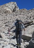
Oh ya, the hike. I finally made it down to the Gateway TH. It was very crowded. I decided to head north on the Desert Park Trail as I had not been on it before and it would hopefully provide the angle I wanted to get my photos. Next I intersected with the Horseshoe Trail, another new trail for me before arriving at the Gateway Loop Trail. I had already encountered a dozen people. Little did I know, this was just the beginning.

I headed south and then east as far as I could to get my shot of snow-capped Thompson Peak with the saguaros in the foreground. But first, I had to get through all these people. I seemed to be heading the wrong way. I felt bad for one older lady that was struggling down this side of the trail. She still had another mile. I don't think the younger folks with her bothered to check the mileage. As continued throngs of people kept coming toward me I forged on. I finally got to the section where I could get my pictures and turn around. At least now I would be going with the flow as I encountered fewer people.

Once back at the bottom toward the TH the throngs seem to re-group or something. It just never stopped the entire way. And now, I hoped to miss the traffic from the Arabian Horse Show as it was later in the afternoon and I did.

The day before slideshow: [ youtube video ]
Snowday :D :
The Drive: [ youtube video ]
The snow with views: [ youtube video ]
The hike: [ youtube video ]
 Named place
 Named place [ checklist ]
[ checklist ]  Saddle Mountain, Tonopah
wildflower observationwildflower observationwildflower observationwildflower observationwildflower observation
Wildflowers Observation Isolated
a few poppies, closed
some Scorpionweed,
some lupine,
one new plant I can't ID
_____________________
For me, sometimes it's just as much about the journey as the destination.
Oh, and once in awhile, don't forget to look back at the trail you've traveled.
 
Oct 13 2018
avatar

 Guides 41
 Routes 1,626
 Photos 14,983
 Triplogs 2,760

69 male
 Joined Jan 20 2009
 Far NE Phoenix,
McD lil' Loop, AZ 
McD lil' Loop, AZ
 
Hiking avatar Oct 13 2018
The_EagleTriplogs 2,760
Hiking6.44 Miles 964 AEG
Hiking6.44 Miles   2 Hrs   5 Mns   3.09 mph
964 ft AEG5 LBS Pack
 
1st trip
Partners none no partners
A little walk to enjoy the petrichor and splash on the trails.
_____________________
There is a very fine line between "hobby" and "mental illness."
Dave Barry 🦅
 
Aug 26 2018
avatar

 Guides 1
 Routes 14
 Photos 7,202
 Triplogs 5,208

68 male
 Joined Mar 16 2008
 chandler,az
Tom's Thumb Trail - MSPPhoenix, AZ
Phoenix, AZ
 Hiking avatar Aug 26 2018
johnlpTriplogs 5,208
 Hiking11.14 Miles 2,691 AEG
 Hiking11.14 Miles   3 Hrs   37 Mns   3.11 mph
2,691 ft AEG      2 Mns Break
 no routes
Partners none no partners
Early start from the Horseshoe trailhead. Tortoise sighting! Mountain Spring is no longer flowing out the pipe. Didn't go all the way up to find the problem. Finished the hike before it got warm. :)
wildflower observationwildflower observationwildflower observationwildflower observationwildflower observation
Wildflowers Observation Isolated
_____________________
“Good people drink good beer.” Hunter S Thompson
 
Oct 14 2017
avatar

 Guides 2
 Routes 25
 Photos 1,890
 Triplogs 604

41 male
 Joined Sep 13 2009
 Mesa, AZ
Desert Park Trail - MSPPhoenix, AZ
Phoenix, AZ
Hiking avatar Oct 14 2017
jochalTriplogs 604
Hiking5.93 Miles 654 AEG
Hiking5.93 Miles
654 ft AEG
 no routesno photosets
Linked   linked  
Partners none no partners
_____________________
 
Sep 30 2017
avatar

 Guides 41
 Routes 1,626
 Photos 14,983
 Triplogs 2,760

69 male
 Joined Jan 20 2009
 Far NE Phoenix,
McDowell Balloon, AZ 
McDowell Balloon, AZ
 
Hiking avatar Sep 30 2017
The_EagleTriplogs 2,760
Hiking12.20 Miles 2,631 AEG
Hiking12.20 Miles   5 Hrs      2.57 mph
2,631 ft AEG      15 Mns Break12 LBS Pack
 
1st trip
Needed to stay in town. This is my go to area for in town, time crunched hikes.
Temps were nice to begin and a bit warm at the end for this cowboy.
Breezes kept it decent most of the day.

All the beautiful people were out today.
Saw a young couple with 2 toddlers in baby backpacks in 100 degree temps, 3 miles from the TH going up as I was going down.
Not sure how smart that was. But didn't see them on the news last night.

water 1 out of 5water 2 out of 5water less than maxwater less than max Mountain Spring Quart per minute Quart per minute
Ole Reliable
_____________________
There is a very fine line between "hobby" and "mental illness."
Dave Barry 🦅
 
Sep 24 2017
avatar

 Guides 20
 Routes 81
 Photos 542
 Triplogs 409

60 male
 Joined Feb 02 2010
 Scottsdale, AZ
Gateway Access Trail Head Meanderings, AZ 
Gateway Access Trail Head Meanderings, AZ
 
Hiking avatar Sep 24 2017
paulshikleejrTriplogs 409
Hiking3.34 Miles 246 AEG
Hiking3.34 Miles   1 Hour   31 Mns   2.51 mph
246 ft AEG      11 Mns Break10 LBS Pack
 no routesno photosets
1st trip
Great Sunday morning hike with Rob. We wandered around the Gateway Access Trail Head area for about an hour and a half.
_____________________
Decisionmaking and action should only be informed by, not subject to, healthy, reasonable concern.
That being said, anything worth doing is worth doing to excess.
 
Apr 30 2017
avatar

 Guides 27
 Routes 669
 Photos 12,096
 Triplogs 856

56 male
 Joined Jul 05 2006
 Mesa, AZ
Desert Park Trail - MSPPhoenix, AZ
Phoenix, AZ
Hiking avatar Apr 30 2017
DarthStillerTriplogs 856
Hiking6.10 Miles 763 AEG
Hiking6.10 Miles   2 Hrs   55 Mns   2.13 mph
763 ft AEG      3 Mns Break
 
Partners none no partners
With a one more week reprieve from the really hot weather, I took advantage and took the wife and kids out for yet another hike. This will likely be the last one they'll do until after the summer, so it was nice to take advantage of the mild and clear weather. The last two times we went out to Lost Dutchman State Park, so in order to avoid burnout with that area, we headed up to the Scottsdale MSP to hike some trails I never did. The Desert Park trail was one I kind of avoided since it seemed to go thru a neighborhood. It kind of skirts a neighborhood, and some housing is in the process of still being built, but it's not that bad.

We took the Desert Park Trail to its terminus, then made a loop by taking the Windgate Pass, Gateway Loop, and Horseshoe Trails back to the car. Along the Desert Park Trail, we saw almost no one. Once back in the preserve and on the Windgate Pass Trail, it was an ant trail. Lots of hikers and trail runners. Nothing real bad though.

it seemed kind of warm to start, but never really got any hotter. In fact, it seemed almost cooler at times along the saddles with the breezes. This turned out to be a really nice hike for the family, glad I saved it. Had lunch afterwards at Sweet Tomatoes in Scottsdale, trying to keep it a little healthy.
_____________________
 
Apr 18 2017
avatar

 Guides 20
 Routes 81
 Photos 542
 Triplogs 409

60 male
 Joined Feb 02 2010
 Scottsdale, AZ
Gateway Meander from the Village, AZ 
Gateway Meander from the Village, AZ
 
 Hiking avatar Apr 18 2017
paulshikleejrTriplogs 409
 Hiking4.40 Miles 838 AEG
 Hiking4.40 Miles   1 Hour   21 Mns   3.47 mph
838 ft AEG      5 Mns Break10 LBS Pack
 no routesno photosets
1st trip
Partners none no partners
Quick morning meander with Rob. Great weekday hike.
_____________________
Decisionmaking and action should only be informed by, not subject to, healthy, reasonable concern.
That being said, anything worth doing is worth doing to excess.
 
Feb 28 2017
avatar

 Routes 36
 Photos 2,658
 Triplogs 1,347

67 male
 Joined Jul 28 2004
 Scottsdale, AZ
MSP (south) loop, AZ 
MSP (south) loop, AZ
 
Hiking avatar Feb 28 2017
mazatzalTriplogs 1,347
Hiking3.50 Miles 400 AEG
Hiking3.50 Miles   1 Hour   30 Mns   2.47 mph
400 ft AEG      5 Mns Break
 no routesno photosets
1st trip
Took out of town visitor on a short loop at Gateway TH:
Desert Park - Horseshoe - Gateway loop - Saguaro loop - Crossover - Levee - 104 St - Equestrian
wildflower observationwildflower observationwildflower observationwildflower observationwildflower observation
Wildflowers Observation Isolated
_____________________
  1 archive
Feb 26 2017
avatar

 Guides 6
 Routes 23
 Photos 1,125
 Triplogs 593

46 male
 Joined May 23 2012
 Mesa, AZ
Micky D Loop, AZ 
Micky D Loop, AZ
 
Hiking avatar Feb 26 2017
syoungTriplogs 593
Hiking14.02 Miles 3,153 AEG
Hiking14.02 Miles   3 Hrs   48 Mns   3.69 mph
3,153 ft AEG
 no routes
1st trip
Decided to head to a place I haven't been before. The journey up Tom's Thumb North was pretty amazing. It reminded me a lot of the Alabama Foothills out by Whitney.

Lost the trail a bit at the East End intersection. Seems ridiculous but I was just enjoying the views and not paying much attention to where I was going. All of a sudden, there is no more trail and I am staring down a cliff at where the trail actually is.

While on the climb up Tom's Thumb North I had to make a nature pit stop. As I was taking care of business I heard a buzzing sound to my side, I turned and saw a hummingbird looking for food in the bush I was at. The next instant the bird is buzzing at my business end examining where all this liquid is coming from. I jumped back as I started laughing. I did not ever expect something like that to happen.
_____________________
  1 archive
Dec 26 2016
avatar

 Guides 41
 Routes 1,626
 Photos 14,983
 Triplogs 2,760

69 male
 Joined Jan 20 2009
 Far NE Phoenix,
Micky D Loop, AZ 
Micky D Loop, AZ
 
Hiking avatar Dec 26 2016
The_EagleTriplogs 2,760
Hiking13.54 Miles 3,157 AEG
Hiking13.54 Miles   5 Hrs   17 Mns   2.60 mph
3,157 ft AEG      5 Mns Break13 LBS Pack
 
1st trip
Went looking for Richard @McDowellMan. He was nowhere to be found
@mazatzal

water 1 out of 5water 2 out of 5water 3 out of 5water 4 out of 5 Mountain Spring Gallon + per minute Gallon + per minute
_____________________
There is a very fine line between "hobby" and "mental illness."
Dave Barry 🦅
 
Sep 11 2016
avatar

 Photos 5,768
 Triplogs 259

59 female
 Joined Jan 04 2012
 scottsdale, AZ
Gateway Loop Trail - MSPPhoenix, AZ
Phoenix, AZ
 Hiking avatar Sep 11 2016
New2hykTriplogs 259
 Hiking3.50 Miles 250 AEG
 Hiking3.50 Miles
250 ft AEG
 no routes
After hearing that some migratory birds were noted here, I managed to hike this morning to see if I can document any . Parking lot was full at 7am as several cars were double parked :o .
Weather was pleasant and saw steady number of people throughout the hike. I saw 2 new species for me :y: . Saw at least 2 more species but couldn't photo document them. Overall great hike.
_____________________
  3 archives
Jan 16 2016
avatar

 Guides 41
 Routes 1,626
 Photos 14,983
 Triplogs 2,760

69 male
 Joined Jan 20 2009
 Far NE Phoenix,
McDowell Loop, AZ 
McDowell Loop, AZ
 
Hiking avatar Jan 16 2016
The_EagleTriplogs 2,760
Hiking18.84 Miles 4,169 AEG
Hiking18.84 Miles   8 Hrs   18 Mns   2.54 mph
4,169 ft AEG      53 Mns Break14 LBS Pack
 
My go to area when I need a workout hike or am limited in time.
Lots of loop opportunities from 5 to 30 miles and as much AEG as you can bite off.

Perfect weather with plenty out enjoying the day. East of the ridgeline you rarely see another. I scrambled south off of the Thompson Peak Trail to meet up with the Quartz trail. On the Quartz trail I spooked 3 mule deer that never went more than 40' from me.
 Fauna
 Fauna [ checklist ]
[ checklist ]  Mule Deer

water 1 out of 5water 2 out of 5water 3 out of 5water less than max Mountain Spring Gallon per minute Gallon per minute
Always gushing
_____________________
There is a very fine line between "hobby" and "mental illness."
Dave Barry 🦅
 
Jan 15 2016
avatar

 Routes 67
 Photos 2,708
 Triplogs 755

89 male
 Joined Mar 28 2008
 Phoenix, AZ
Windgate Bell LoopPhoenix, AZ
Phoenix, AZ
Hiking avatar Jan 15 2016
Tough_BootsTriplogs 755
Hiking10.60 Miles 2,151 AEG
Hiking10.60 Miles
2,151 ft AEG
 no routesno photosets
1st trip
I couldn't be out of cell phone range today but wanted a few miles so I tried this one. I'm renaming it the "Soccer Mom Loop". Every single hiker seemed to have bathed in perfume or body spray. Easy miles and an easy 2,000 ft.

I give this hike an "ehhh out of five".
_____________________
 
Dec 23 2015
avatar

 Guides 6
 Routes 183
 Photos 5,612
 Triplogs 1,647

male
 Joined Mar 12 2004
 Scottsdale, AZ
Gateway Loop Trail - MSPPhoenix, AZ
Phoenix, AZ
Hiking avatar Dec 23 2015
John9LTriplogs 1,647
Hiking5.50 Miles 935 AEG
Hiking5.50 Miles
935 ft AEG
 no routesno photosets
Quick after work hike in the McDowells. I went out of my way to avoid the heavily congested areas.

Desert Park Trail :next: Horseshoe Trail :next: Gateway Loop :next: Levee Trail :next: Equestrian Bypass
_____________________
  1 archive
average hiking speed 2.41 mph
1, 2, 3, 4, 5  Next

WARNING! Hiking and outdoor related sports can be dangerous. Be responsible and prepare for the trip. Study the area you are entering and plan accordingly. Dress for the current and unexpected weather changes. Take plenty of water. Never go alone. Make an itinerary with your plan(s), route(s), destination(s) and expected return time. Give your itinerary to trusted family and/or friends.

helpcommentissue

end of page marker