|
| | | |
| |
|
| Hiking | 9.80 Miles |
1,600 AEG |
| | Hiking | 9.80 Miles | 7 Hrs | | 1.40 mph |
| 1,600 ft AEG | | | | |
|
|
| |
| Partners |
|
[ show ]
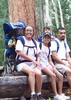
| partners | | superfragilisticexpialidocious which is also apropos to the movie it came from as we did carry and use our umbrellas... but we couldn't fly  . .
In my humble opinion, if this hike is not at the top of your wishlist, it should be. The pictures just don't do it justice. We took the 8:30 shuttle to Echo Canyon Parking Lot and from there we hiked the Echo Canyon trail, to Hailstone (incredibly enough, appropriately named due to the geology along the trail), to Mushroom Rock, out and back to Inspiration Point, to Big Balanced Rock, loop thru Heart of the Rocks (a MUST see if you hike this area), to Sarah Deming & finishing on Rhyolite.
The place is unbelieveable.
There were certain areas that Writelots had trouble getting me to get around the corner. She deserves kudos for keeping me moving. The temps got a little toasty once in awhile but not bad. There were a couple elevations that just seemed a bit longer than I anciticipated but nothing too strenuous (for me anyway). We were lucky to have beautiful skys and at times cloud cover, especially up at the Heart of the Rocks, that made it seem nowhere near the mid to high 90s.
This is definitely a place that is non-stop amAZing.  The trail is wonderfully kept so you can do a limited amount of gawking while walking. We only saw 8 other people along the way. Our best treat was a family of coatamundis. I did get a picture of one of the little ones before he scampered off to join the rest of the family. Oh, there were lots of colorful and pretty good-sized lizards too. The trail is wonderfully kept so you can do a limited amount of gawking while walking. We only saw 8 other people along the way. Our best treat was a family of coatamundis. I did get a picture of one of the little ones before he scampered off to join the rest of the family. Oh, there were lots of colorful and pretty good-sized lizards too.
On Saturday nite, I had dinner with Wendy and Gary at El Charro Cafe and had my first taste of Carne Seca in a burrito. Let me tell you, that carne seca is very good. So now I am on the look out for restaurants in the Valley that serve it. |
|
Wildflowers Observation Isolated
|
|
| _____________________
For me, sometimes it's just as much about the journey as the destination.
Oh, and once in awhile, don't forget to look back at the trail you've traveled. |
| | |
|
|
|
 Route Editor


 The campground host was being very lenient, to say the least. Anyway, I got way more for my $3 camping fee than I should have been entitled to in entertainment alone!

 Anyways, we continued on and stopped for a quick snack. From there we connected to the Ed Riggs trail and were back at the parking lot in no time. Cheryl and I both enjoyed the hike and were on to the next adventure.

