username
X
password
register
for free!
help
ArticlesGuidesRoutes
 
Photosets
 
 Comments
triplogs   photosets   labels comments more
Hoolie Bacon - Peters Trail Loop - 18 members in 41 triplogs have rated this an average 2.8 ( 1 to 5 best )
1, 2, 3  Next
41 triplogs
login for filter options
Jan 31 2025
avatar

 Routes 255
 Photos 1,071
 Triplogs 245

68 male
 Joined Feb 10 2008
 Kent,wa
Hoolie Bacon - Peters Trail LoopPhoenix, AZ
Phoenix, AZ
Hiking avatar Jan 31 2025
fdv75Triplogs 245
Hiking10.88 Miles 1,864 AEG
Hiking10.88 Miles   5 Hrs   17 Mns   2.29 mph
1,864 ft AEG      32 Mns Break
 
1st trip
Linked   none no linked trail guides
Partners none no partners
Used a lifted jeep (with lockers) to drive the terrible "road" to the trailhead. Extended the loop to explore Tarp Canyon and see the cliff dwelling area. First time on these scenic trails, just wish the road was maintained so everyone could experience them.
_____________________
 
Dec 14 2024
avatar

 Guides 17
 Routes 297
 Photos 1,808
 Triplogs 276

female
 Joined Mar 11 2002
 Gilbert, AZ
Hoolie Bacon - Peters Trail LoopPhoenix, AZ
Phoenix, AZ
Hiking avatar Dec 14 2024
VashtiTriplogs 276
Hiking14.43 Miles 2,191 AEG
Hiking14.43 Miles   8 Hrs   20 Mns   2.21 mph
2,191 ft AEG   1 Hour   49 Mns Break
 
1st trip
Partners partners
DesertNymph
Route Scout Route Recorded  on Route Scout | Pop | Map | Popup | MapDEX
Well. I am horrifically disappointed that my Jeep Grand Cherokee did not make it up Fr213. Sigh. And really, when does something cease to be called a road?? I'm bitter, I know. The hike itself was fine, but not sure the extra 6 miles RT on the road was worth it. Also not worth it... Wrecking the underside of my car!! Okay. Enough of that. Maybe...🤣🤣🤣

The on trail parts were fine and easy to follow. I wasn't sure if this would be the case given that it is a less accessible Trailhead. Less accessible to Me, anyway!! (bitterness! 🤣🤣). Not less accessible to the off road golfcarts that made it to the actual Trailhead. One of whom had an absolutely palatial canvas tent set up right next to the Peter's trail sign. There were 2 total at the Trailhead when we arrived, and the one near the Hoolie Bacon sign was gone when we arrived back at the end of the loop. We saw no people the entire day which was glorious! 😁

It was an absolutely beautiful day to be outside! The views are superb on the Peter's trail. I loved the majestic views of the ridge off to the northwest. And after finishing the climb, the views to south were also stunning. There is no clear trail to cut over to the Hoolie Bacon, just a sea of catclaw to navigate! 🙀🙀 It wasn't as bad by the Peters trail, but somewhere around halfway through the off trail section, it became catclaw central. That being said, it was still worth it to cut off the additional mileage for us. We were happy to follow the wash back up to Hoolie Bacon. After a snack, we headed up to the saddle, and then it was a steep down. The lichen-covered red ridges are a pretty sight headed back towards the Trailhead.

That last quarter of the loop is rather lackluster. It looks like a giant dirt plain in areas. Very non descript. Anyway, it was nice to be back on trail and making good time. We waited for stragglers at the actual Trailhead, and then set off on our 3 mile road walk back to the cars (grumble, grumble, bitter! 🤣).

I was so excited to try a new trail in the supes! 😁

So the question is... What type of vehicle does make it to the TH?? Clearly lots of people do (or try given the scrapes on the obstacle rocks as evidence).

No water to speak of, unsurprisingly. It certainly would be a sight after a wet spell! 😁
foliage observationfoliage observationfoliage observationfoliage observationfoliage observation
Autumn Foliage Observation Isolated
A few Sycamore here and there.
wildflower observationwildflower observationwildflower observationwildflower observationwildflower observation
Wildflowers Observation Isolated
Surprised to see a few tiny purple flowers.

dry Indian Spring Dry Dry

dry Kane Spring Dry Dry

dry Peters Canyon Dry Dry
_____________________
:D
  2 archives
Dec 14 2024
avatar

 Routes 43
 Photos 2,120
 Triplogs 81

female
 Joined Dec 09 2024
 
Hoolie Bacon - Peters Trail LoopPhoenix, AZ
Phoenix, AZ
Hiking avatar Dec 14 2024
DesertNymphTriplogs 81
Hiking14.48 Miles 2,125 AEG
Hiking14.48 Miles   8 Hrs   14 Mns   1.90 mph
2,125 ft AEG      36 Mns Break
 
1st trip
Partners partners
Vashti
I haven't hiked this trail since the late 90's/early 2000's....at that time I did the full loop from the official trailhead and the sparse trip report from that time mentioned faded trails and catclaw...

This most recent hike was from 88, so included the extra 6 miles of road-walking to the abbreviated Hoolie Bacon - Peters Trail loop. The established trails were easy to follow, though the regions around Tortilla Creek have some braided trails and appear to be used by cattle. Additionally, there is a fair bit of catclaw present, so take heed and dress accordingly.

The first portion of the hike along Peters Trail was quite lovely with beautiful views...the cross country bit involved navigating thickets of catclaw - aside from finding a path through the catclaw, the cross country jaunt was straightforward, especially with the help of a pre-plotted route for guidance.

I'm glad to have discovered that I still have the knack for making it through catclaw relatively unscathed. I sustained a few nicks and a scratch or two, but not bad considering I did the hike without long pants and in a sleeveless top. That low damage rate means I'm moving relatively slowly, picking my way carefully through the snaggy bits. If I had it to do again, I'd probably do the Peters trail as an out and back.
_____________________
Happier when hiking....I may not move fast (and I'm often distracted by wildflowers), but I'll get there eventually 😆
  1 archive
Feb 24 2024
avatar

 Guides 94
 Routes 840
 Photos 22,055
 Triplogs 1,993

52 male
 Joined Sep 18 2002
 Tempe, AZ
Holy Bacon Peter, AZ 
Holy Bacon Peter, AZ
 
Backpack avatar Feb 24 2024
chumleyTriplogs 1,993
Backpack25.44 Miles 4,298 AEG
Backpack25.44 Miles2 Days         
4,298 ft AEG
 no routes
1st trip
Needed to get outside again. A warm Feb weekend, with temps in the mid 70s was softened by cloudiness both Sat and Sun.

Bland scenery on Hoolie with the fire scar taking its toll, though the views were distant. Red Tanks through upper La Barge is rough but a highlight of scenery on the loop. Dutchman is a highway in this stunning supes canyon.

FOTG had claimed the best campspot along the creek, so we settled for option 2 not wanting to encroach on a romantical weekend in the woods. ;)

We took an afternoon jaunt up Trap, which was a real treat, and one I'd like to explore the rest of the way. Unfortunately, sunset forced a turnaround and we headed back to camp for the night. A full moon lit up the sky and temps dropped to 41, about 10 lower that we had expected, but somehow we managed to survive the night.

FOTG stopped by for a few minutes in the ayem on his way out before we headed our own way down toward Charley and Peter. Climbing up to the mesa reintroduced fire damage and the mesa was a mess. The catclaw is prolific and the tread is tough to follow in some places. The five red-spray-painted rocks along the way were instrumentally important in finding the way. :-k :doh:

The last two miles along upper Tortilla is a treat with cool geology and plenty of water right now. On the drive out we passed a Jeep Liberty heading up the 213, and I'm pretty sure they were on an intentional one-way trip. Best wishes to those folks and whoever's car they stole. :sweat:
 Named place
 Named place [ checklist ]
[ checklist ]  LaBarge Spring

water 1 out of 5water 2 out of 5water less than maxwater less than max LaBarge Spring Quart per minute Quart per minute
No need for the spring, as the creek was flowing nicely. But there was nice flow from the pipe and a full springbox. It's an overgrown mess to get up to it though, and not easy to find if you don't know it's there.

water 1 out of 5water 2 out of 5water less than maxwater less than max Oak Spring Quart per minute Quart per minute
Didn't go up to the source, but there was a visible flow in the drainage at the trail crossing.

water 1 out of 5water 2 out of 5water less than maxwater less than max Peters Mid-Upper Along Trail Light flow Light flow
Peters was flowing the entire length

dry Tortilla Well Dry Dry
No sign of water at the well or trough. Plenty in the adjacent creek however.

water 1 out of 5water 2 out of 5water less than maxwater less than max Trap Canyon Light flow Light flow

water 1 out of 5water 2 out of 5water 3 out of 5water less than max Trap Canyon Spring Gallon per minute Gallon per minute
Didn't find the actual spring source ... plenty of flow in the canyon.

water 1 out of 5water 2 out of 5water less than maxwater less than max Upper LaBarge Box Canyon Light flow Light flow

water 1 out of 5water 2 out of 5water less than maxwater less than max Whiskey Spring Canyon Light flow Light flow
_____________________
I'm not sure what my spirit animal is, but I'm confident it has rabies.
  3 archives
Feb 04 2024
avatar

 Guides 59
 Routes 1,100
 Photos 1,191
 Triplogs 1,290

male
 Joined Jan 01 2023
 Arizona
Fish Taco with Bacon, AZ 
Fish Taco with Bacon, AZ
 
Hiking avatar Feb 04 2024
pseudalpineTriplogs 1,290
Hiking17.24 Miles 3,789 AEG
Hiking17.24 Miles   7 Hrs   54 Mns   2.37 mph
3,789 ft AEG      38 Mns Break
 
1st trip
Route Scout Route Recorded  on Route Scout | Pop | Map | Popup | MapDEX
It was necessary to modify a route up to Tortilla Mountain because I didn't account for most of the creeks in the area essentially being rivers. Which was fine because sometimes exploring off the beaten path leads to interesting discoveries. TM most definitely is a nice Supes summit, considering it's the highest point for miles around with great views, especially snowy Four Peaks. I descended a more inspiring route (I think jacobemerick's Jan.'17 track) than the official route and then integrated the crappy Rippin' and the Tearin' Horse Basin crossover and some of Fish Mesa into a CCW loop. Unfortunately, I forgot to run-up Hoolie Bacon to Peak 4143. I'll admit that HB is somewhat growing on me, since for once its banality was muted by the sound of rapids. Water reports seem superfluous currently because moisture is seeping from every crevice, side drainage and flowing down the muddy trails. And there's another storm forecasted, so it should be a good wildflower season again.
  13 archives
Dec 16 2023
avatar

 Guides 3
 Routes 632
 Photos 8,235
 Triplogs 604

54 male
 Joined Apr 13 2011
 Gilbert, AZ
Tortilla Super LoopPhoenix, AZ
Phoenix, AZ
Hiking avatar Dec 16 2023
ddgrunningTriplogs 604
Hiking26.60 Miles 3,720 AEG
Hiking26.60 Miles   10 Hrs   12 Mns   2.75 mph
3,720 ft AEG      31 Mns Break
 
1st trip
Route Scout Route Recorded  on Route Scout | Pop | Map | Popup | MapDEX
I didn’t have the rock crawling skills to drive to the Peters trail TH, so I parked and started from the Tortilla TH, which added another 7 miles round trip.

Peters Trail—Now I know where the term “peters out” comes from. 😄 This trail does so early and often. Nature is reclaiming this one, and in my view, having a gps track is essential. There were periodic cairns, but standing at the cairn, it was often difficult to figure out which direction to go from there. Most of this trail is pretty blah by Superstition standards, with the exception of the initial jaunt through a brief canyon, and then on the back end, as you descend to the Dutchman junction.

From there, I tacked on a quick side trip to Charlebois Spring, which was showing its fall colors and full of water, per usual. Met my first fellow traveler at the spring, a solo backpacker on his second night. We visited and he graciously guided me to the petroglyph panel. Cool to see.

From there, I headed down Dutchman and the first section of Red Tanks, both of which were smooth sailing. Enjoyed some fun fall colors at the springs.

Upper La Barge Box was a highlight. Overgrown in spots but not too bad as far as route finding goes.

Hung a left at the Hoolie Bacon junction and was concerned about a repeat of the Peters Trail route finding issues. But, while the trail is indistinct in many places and a bit brushy here and there, it is very well cairned and route finding was rarely an issue. Not particularly scenic though.

Finished the loop, and with the 3.5 mile road walk left, I knew I’d be fighting for daylight. Enjoyed a lovely sunset and threw on the headlamp for the last half mile.

Tons of solitude to be had on this loop. Long pants are a must, to keep the lacerations to a minimum. On that note, don’t wear clothes that you care about, as the desert pokies are unavoidable and will extract their cheese-grater dues.

A full day in the Supes!
_____________________
  2 archives
Mar 14 2020
avatar

 Routes 268
 Photos 2,969
 Triplogs 541

66 male
 Joined Aug 16 2009
 Mesa,AZ
Hoolie Bacon - Peters Trail LoopPhoenix, AZ
Phoenix, AZ
Hiking avatar Mar 14 2020
hikerdwTriplogs 541
Hiking14.23 Miles 2,142 AEG
Hiking14.23 Miles   6 Hrs   48 Mns   2.43 mph
2,142 ft AEG      56 Mns Break
 
Partners none no partners
This was my third trip to the area since the fire, the previous trips were in August and September, just prior to the lengthy road closure. Even in this short time, the recovery is very much evident. Mother Nature curing the carelessness of man.

FR 213 Walk
Always a soothing walk in the morning. Large puddles post rain. Evident that there hasn't been much vehicle travel in the last 6 or so months. Passed one set of campers near the ranch site. Saw two deer.

.8 miles of JF Trail
Pretty much a gully as this early section of the trail hasn't seen any recent maintenance. Once you hit the fence post it gets a little better but not much. Saw one deer near the JF/Hoolie Bacon junction.

Hoolie Bacon Trail
The section from the JF Trail to Tortilla Creek is in average condition compared to itself, but is in no way groomed. At the creek crossing the flow was fairly quick so knowing that the trail crossed back over we decided to stay on the east side of the creek off trail which worked out well. Re-joined the trail where it crossed back over. Fire damage was very evident near the Nighthawk Spring trough. This was always a very peaceful, mystic area for me. It has changed but still has that lure. The trail up to Horse Ridge was in fairly decent shape and we made good time. On the other hand, the trail condition on the decent down wasn't as good. We lost the tread a couple times.

Off Trail between Hoolie Bacon and Peter's Trails
The corral survived the fire :y: Off trail conditions were not too bad, as a lot of the catclaw hasn't returned to it's full force yet. Ran across what appeared to ba a game camera. Had lunch on the ridge that separates the two trails then followed our typical route along a drainage down to Peter's Trail.

Peter's Trail
In comparison to the Hoolie Bacon Trail, Peter's is in worse shape. Passed a lone hiker in colourful attire near the Horse Ridge saddle. Lot's of burned trees encountered as we neared Kane Spring. Running water everywhere. As we did off Hoolie's, we went off trail in sections to avoid the fast moving creek where we could but in some areas we just got wet. Lot's of charred trees and brush along the creek so skin and clothes got black blazes along the way. Took a well earned break at the Well site before we made the road trek back to the car.

Even post fire I would rate this area of the Superstition Wilderness above most others. If you could match a hiker to a set or style of trails, this would be my perfect match.

water 1 out of 5water 2 out of 5water 3 out of 5water less than max Cedar Basin Canyon Medium flow Medium flow

water 1 out of 5water less than maxwater less than maxwater less than max Kane Spring Dripping Dripping
_____________________
Expect to self rescue
  1 archive
Feb 02 2019
avatar

 Guides 1
 Routes 447
 Photos 4,407
 Triplogs 938

68 male
 Joined Mar 09 2012
 Gilbert, AZ
Hoolie Bacon - Peters Trail LoopPhoenix, AZ
Phoenix, AZ
Hiking avatar Feb 02 2019
rayhustonTriplogs 938
Hiking14.96 Miles 2,241 AEG
Hiking14.96 Miles   6 Hrs   55 Mns   2.27 mph
2,241 ft AEG      20 Mns Break
 
1st trip
Partners none no partners
Trip #41 of the Hikers Guide to the Superstition Wilderness. I walked SR213 to Tortilla Ranch, as most do given the nearly impassable start to that road. Once on the JF trail, I followed their instructions as much as possible. I also brought a track left by @hikerdw just to make sure I had a way out if I needed it. This area is all new to me; safety first. The hike is described as difficult. There are a few stretches where I would agree with that.

I had overcast skies and a nice breeze for most of the day. The sun came out during the last half mile of Peter's trail and for most of the walk back on SR213. I saw a father and son at the start of the loop and another couple in the exact same location four hours later. Though not warm, it was humid. I brought 3 quarts of water and drank 2.

The open terrain on the Hoolie Bacon trail provides great views of the distant mountains. The views from Horse Ridge pass are excellent. The bushwhack to Peter's trail is way more than tedious. Long pants and long sleeves are required or there will be blood. Once on Peter's trail it was like being on a freeway. Let's get moving!

I stopped at the high pass on Peter's trail for lunch before starting down the steep and loose descent to the canyon below. Aside from the steep and loose, I found this section to be the best part of the loop. Lots of water in Tortilla Creek at the bottom. With the forecasted rain this week, it should be amazing next weekend.
 Flora
 Flora [ checklist ]
[ checklist ]  Coulter's Lupine
 Culture
 Culture [ checklist ]
[ checklist ]  Horseshoe
wildflower observationwildflower observationwildflower observationwildflower observationwildflower observation
Wildflowers Observation None
Nothing to speak of. Some desert mallow in one spot and a lone Coulter's Lupine on the road back.


water 1 out of 5water less than maxwater less than maxwater less than max Indian Spring Dripping Dripping
Plenty of water in Tortilla Creek

water 1 out of 5water less than maxwater less than maxwater less than max Kane Spring Dripping Dripping


dry Tortilla Well Dry Dry
_____________________
 
Jan 20 2019
avatar

 Routes 93
 Photos 7,758
 Triplogs 1,691

64 male
 Joined Mar 11 2003
 AZ
Hoolie Bacon - Peters Trail LoopPhoenix, AZ
Phoenix, AZ
Hiking avatar Jan 20 2019
wallyfrackTriplogs 1,691
Hiking12.75 Miles 1,368 AEG
Hiking12.75 Miles   4 Hrs   35 Mns   2.78 mph
1,368 ft AEG
 no routes
Linked   none no linked trail guides
Partners none no partners
A trip to look for some old stone houses near Peters trail. There was some interesting spots on satellite but there was nothing there. Tortilla Creek had a nice flow. Other than the group camped at Peters trailhead, there were no other hikers seen on the trails. On the way out I looked for some routes to drop down to Tortilla Creek for future exploring.
_____________________
  1 archive
Nov 04 2017
avatar

 Routes 268
 Photos 2,969
 Triplogs 541

66 male
 Joined Aug 16 2009
 Mesa,AZ
Hoolie Bacon - Peters Trail LoopPhoenix, AZ
Phoenix, AZ
Hiking avatar Nov 04 2017
hikerdwTriplogs 541
Hiking14.10 Miles 2,035 AEG
Hiking14.10 Miles   7 Hrs      2.35 mph
2,035 ft AEG   1 Hour    Break
 
Linked   linked  
Partners none no partners
Hiked Peter's Trail to the pass then across the back side of Horse Ridge to do some exploring. Lots of catclaw but to be expected. Scared up a couple white-tail deer who looked surprised to see us. We then headed towards peak 4066 and made our decent on the right or east side dropping down onto Little Hawk Spring. Enjoyed lunch and a break at the spring and then continued down the drainage to the wash, then continued east to meet up with the Hoolie Bacon Trail which we then followed back to the trailhead. Great weather, overcast and even a brief rain shower.
foliage observationfoliage observationfoliage observationfoliage observationfoliage observation
Autumn Foliage Observation Isolated
Some trees along Tortilla Creek were showing some nice yellow foliage.

water 1 out of 5water 2 out of 5water less than maxwater less than max Little Hawk Spring Quart per minute Quart per minute
Nice pool of water.
_____________________
Expect to self rescue
 
Feb 25 2017
avatar

 Guides 1
 Routes 1
 Triplogs 24

45 male
 Joined Feb 27 2012
 Cochise County
Hoolie Bacon - Peters Trail LoopPhoenix, AZ
Phoenix, AZ
Hiking avatar Feb 25 2017
AndrewAZTriplogs 24
Hiking23.98 Miles 4,004 AEG
Hiking23.98 Miles   10 Hrs   40 Mns   2.25 mph
4,004 ft AEG
 no routesno photosets
1st trip
Partners none no partners
I parked at the 2wd trailhead just after 6:30 am and was hiking by 6:50. Wisdom being the better part of valor, I opted not to drive the 4wd road since I've never been up it before. I'm glad I made that choice. I probably could've made it up the road with my Tacoma with a skid plate and all-terrain tires, but it wouldn't have been fun.

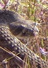
The three road miles were quick and a good warm-up (or so I told myself). Started up JF to Hoolie Bacon to do the clockwise loop. At the first major water crossing, I startled three whitetails. Until the spot where one can bushwhack over to Peters Trail, HB was pretty easy to follow. After that point, it became awfully theoretical in places. Parts of it reminded me of Two Bar Ridge Trail, and that's not a good thing.

One of my brand-new Black Diamond Z Poles snapped 5 miles into the hike. The internal string broke inside the handle. My first pair of Z Poles lasted over 1000 miles, and this one gave out at under 20 miles. Defective, I hope, and not a sign of decreasing quality at BD. Having one break was frustrating since my 3wd speed is not nearly as good as my 4wd speed, and my stability is definitely worse.

Red Tanks was better quality than the second half of HB, although that's not saying much. After climbing up and over along the canyon wall, it disappeared for a while when it dropped back down to the creek. I assume it goes down the wash, but that's a challenge when there's several feet of water flowing down it. I ended up bouldering down the center of the creek, which was perhaps a bad idea. Some pretty big drops and leaps. Eventually found the trail again and it was well-marked from there to the Whiskey Spring junction.

In comparison, the part after the junction was a highway. I passed one woman along that stretch and she was the first human I'd seen all morning. She had a Gossamer Gear Mariposa and looked to be loaded for camping. I recently got a GG Mariposa and was using it for the first time as a day pack. What are the odds?

The water crossings on Dutchman were a little easier than in January, but not by much. Still some very large pools of water in places.

The drop in trail quality from Dutchman to Peters after taking 10 steps was amusing. It was a steep, hot climb in the afternoon sun, and once again the trail reminded me of Two Bar. Once I was up on the mesa, there was a little bit of air movement and the temperature was pleasant. The trail dropped again into a drainage, and it was the climb from that drainage where I could feel that I was running out of gas. I had powered up the climb from Dutchman, but this smaller climb took it out of me.

I had hit 18 miles, and I was getting pretty smug. I had only seen 1 person, and I had seen 3 whitetails. How many times can you see more deer than humans in the Superstitions? Of course, I ran into 2 hikers shortly thereafter to ruin the ratio. They were loaded for camping and looked a little tired. I discovered why when I made that drop past Kane Spring. Talk about steep and rocky and unstable trail. I was very thankful to be going down that section and not climbing it with a full pack.

About a mile from the 4wd trailhead, I ran into two guys and a dog splashing in the big pools of water and drinking beer (the dog looked like he might've been underage). I got my feet wet at the second-to-last water crossing when the rocks rolled under my feet, so I got to do the roadwalk with wet, sore feet. However, I was thankful I wasn't trying to navigate the road with my truck (manual truck + sore feet + rough road = not a good time).

On the way out, I caught and passed a guy on a bike with a very large hunting pack (at least two rifles). I think he was training or practicing, but he appeared to have more of a cyclocross bike than true mountain bike. He was having a tough time on the rocky shelves and it looked hard to balance with the big pack.

I carried a filter all day, but the 2L of water I started with ended up being enough. Just barely. This was a great hike and one that can finally be crossed off my to-do list.
_____________________
  1 archive
Feb 07 2017
avatar

 Guides 1
 Routes 23
 Photos 579
 Triplogs 45

male
 Joined Jan 10 2014
 Fountain Hills,
Hoolie Bacon - Peters Trail LoopPhoenix, AZ
Phoenix, AZ
Hiking avatar Feb 07 2017
GeeEssTriplogs 45
Hiking7.90 Miles 1,797 AEG
Hiking7.90 Miles   5 Hrs   20 Mns   1.87 mph
1,797 ft AEG   1 Hour   6 Mns Break
 
1st trip
Linked   none no linked trail guides
Partners none no partners
Superstition is an odd place to hike IMHO. Plenty of small hikes that don't gain much elevation, and plenty of really big hikes/backpacks, but not much in the way of the kind of intermediate distances/elevation gains that are within my comfort zone (if anyone here has yet to tackle Roger's Trough, call in sick tomorrow and do it!). So I was looking around my topo maps trying to find something, and came up with this loop. I then visited the hiking site here and discovered, not so surprisingly, that others had had the same notion. It was an OK hike and generally pleasant area, with one notable exception. The fairly brief bushwhack between the two trails was an absolute catclaw acacia ambush -- not fun. The drive in was also a bit challenging for my raised Jeep w/35s. Drive was OK, but I don't think I would have tried it w/33s. Lots of water out there, and the multiple crossings along the start of Peter's Trail were a bit tiresome, but it was all good once the trail starting gaining elevation. I'll be honest, I don't believe I'll be back for a repeat any time soon.
 Flora
 Flora [ checklist ]
[ checklist ]  Dudleya
_____________________
 
Jan 28 2017
avatar

 Routes 67
 Photos 966
 Triplogs 694

51 female
 Joined Jan 05 2012
 Phoenix,AZ
Hoolie Bacon - Peters Trail LoopPhoenix, AZ
Phoenix, AZ
Hiking avatar Jan 28 2017
slowandsteadyTriplogs 694
Hiking19.56 Miles 3,895 AEG
Hiking19.56 Miles   10 Hrs   11 Mns   2.05 mph
3,895 ft AEG      38 Mns Break
 no routesno photosets
1st trip
_____________________
 
Jan 28 2017
avatar

 Guides 4
 Routes 491
 Photos 10,890
 Triplogs 1,257

55 male
 Joined Nov 20 2012
 Phoenix, AZ
Hoolie Bacon - Peters Trail LoopPhoenix, AZ
Phoenix, AZ
Hiking avatar Jan 28 2017
BiFrostTriplogs 1,257
Hiking19.56 Miles 3,895 AEG
Hiking19.56 Miles   10 Hrs   11 Mns   2.05 mph
3,895 ft AEG      38 Mns Break
 
1st trip
With all the water in the Supes we set out again to see just how much was flowing. But before starting we decided to drive the crappy 4wd road from the Tortilla TH to the start of Peters Trail. It's about 3 mile road but the first 1/2 mile is the really bad section and after that uneventful. Arriving at Peters Trail it was still cool at 39 degrees and the trail immediately goes into a fork of Tortilla Creek. Lots of water in the creek and it became apparent that keeping feet dry would either be impossible or take too much time. The trail is in decent shape besides the crossings and follows one of the Tortilla Creek forks until it goes over a saddle and then dropped into Peters Canyon. Here again there was plenty of water flowing in the creek just like Tortilla.

Followed Peters downstream for another mile and half where the trail abruptly leaves the canyon and heads up a side drainage to another saddle. We went up and over the mesa before dropping into La Barge Canyon but just before that we ran into a trail crew clearing their way up Peters Trail. Surprised to see a crew clearing this trail but it was welcome maintenance since Peters is in rough shape compared to other popular Supes trails.

Upon reaching La Barge Canyon we headed over to Charleblois Spring and had lunch. Several people camped before the spring but we had the spring to ourselves. However, just leaving the spring we ran into @lindaagm and @The_Whit coming from Peralta TH. We took a few minutes to chat...nice to see Linda and Whitney again! After that we headed up La Barge Canyon towards the Red Tanks Junction. Now on Red Tanks this was new trail for us and pretty fast section with a few creek crossings and more water. At the top section of Red Tanks it goes through the most scenic section of the loop the Upper La Barge Box. Really awesome section but unfortunately it was getting late and would have been nice to explore the canyon especially with so much water.

Continuing on we reached the Hoolie Bacon junction and headed up this trail making the turn back towards the vehicle. Hoolie Bacon trail was like Peters being very rough and added catclaw for fun. But again there was plenty of water at virtually every drainage crossing. Up and over a couple of ridges the trail eventually makes it back into Tortilla Canyon to finish up the loop. We made it to the vehicle just as it was getting completely dark. Definitely would like to come back and spend more in Upper La Barge Box and Trap Canyon when there is water like right now.

water 1 out of 5water 2 out of 5water 3 out of 5water 4 out of 5 Cedar Basin Canyon Heavy flow Heavy flow
heavy flow

water 1 out of 5water 2 out of 5water 3 out of 5water 4 out of 5 Charlebois Canyon Heavy flow Heavy flow
heavy flow

water 1 out of 5water 2 out of 5water 3 out of 5water 4 out of 5 Charlebois Spring Gallon + per minute Gallon + per minute
mini waterfall coming out of the spring

water 1 out of 5water 2 out of 5water 3 out of 5water 4 out of 5 Upper LaBarge Box Canyon Heavy flow Heavy flow
heavy flow with many pools
_____________________
  1 archive
Dec 27 2016
avatar

 Photos 281
 Triplogs 222

45 male
 Joined Aug 03 2008
 Chandler, AZ
Tortilla Super LoopPhoenix, AZ
Phoenix, AZ
Hiking avatar Dec 27 2016
knmurphyTriplogs 222
Hiking17.80 Miles 3,500 AEG
Hiking17.80 Miles   8 Hrs   24 Mns   2.38 mph
3,500 ft AEG      55 Mns Break
 no routesno photosets
1st trip
Great hike, perfect weather today. There is water everywhere, all the creeks are flowing.
_____________________
 
Feb 17 2016
avatar

 Routes 110
 Photos 670
 Triplogs 204

74 male
 Joined Nov 02 2013
 Apache Junction,
Hoolie Bacon - Peters Trail LoopPhoenix, AZ
Phoenix, AZ
Hiking avatar Feb 17 2016
rtaylor3235Triplogs 204
Hiking7.80 Miles 1,551 AEG
Hiking7.80 Miles   4 Hrs   56 Mns   2.04 mph
1,551 ft AEG   1 Hour   7 Mns Break15 LBS Pack
 
1st trip
Partners partners
hikingaz2
Headed out JF Trail, hooked up with Hoolie Bacon about a mile out and ended up linking it to Peter's Trail by bushwacking about two miles. Hoolie Bacon trail is in pretty bad shape, Bob trimmed some as we went along, but it needs a full crew to get it back in acceptable condition. It seems like the catclaw this season is worse than ever, the bushwacking section nearly tore our clothes off. Only saw one other hiker all day, the 3-1/2 mile walk in from the road to the trailhead keeps many folks away, we took the RZR in. Running water still in Tortilla creek. Weather's warming up, take plenty of fluids, you'll be glad later.
 Culture
 Culture [ checklist ]
[ checklist ]  HAZ Gear
_____________________
 
Feb 17 2016
avatar

 Guides 1
 Routes 169
 Photos 1,616
 Triplogs 218

81 male
 Joined Dec 16 2011
 Mesa,Az
Hoolie Bacon - Peters Trail LoopPhoenix, AZ
Phoenix, AZ
Hiking avatar Feb 17 2016
hikingaz2Triplogs 218
Hiking8.54 Miles 1,599 AEG
Hiking8.54 Miles   5 Hrs   3 Mns   2.25 mph
1,599 ft AEG   1 Hour   15 Mns Break12 LBS Pack
 
1st trip
Partners partners
rtaylor3235
Went back out to the Tortilla TH to do the Hoolie Bacon - Peters Trail Loop ( Thanks hikerdw for the guidance of your GPS Route ) Really does give you a sense of what this area has to offer. A Million Words of Caution ----- Wear long Pants, Long sleeves, get your suntan on a different hike, because you will encounter the dreaded Jungle of Cats--Claw !!!! from the lower part of Hoolie Bacon all across to the Peters Trail.... Didn't see much Wild life, but Rick spotted a couple of deer down in the wash, managed one picture worth keeping :oops: Met only one soul heading up to Peter's Pass as we were heading down. Came across 3 hikers as we were heading back to 88 about 2 miles in,, stopped and visited for awhile, noticed only one had water in a small camelbak, asked if they had enough water ---- Yes, are you sure ?? advised them to be careful and not go to far, I think some don't really get it :SB: Be Prepared when you go out and know your limits !!!

water 1 out of 5water less than maxwater less than maxwater less than max Tortilla Well 1-25% full 1-25% full
_____________________
 
Feb 06 2016
avatar

 Guides 6
 Routes 183
 Photos 5,612
 Triplogs 1,647

male
 Joined Mar 12 2004
 Scottsdale, AZ
Tortilla Super LoopPhoenix, AZ
Phoenix, AZ
Hiking avatar Feb 06 2016
John9LTriplogs 1,647
Hiking23.76 Miles 4,147 AEG
Hiking23.76 Miles   10 Hrs   25 Mns   2.66 mph
4,147 ft AEG   1 Hour   30 Mns Break
 no routesno photosets
1st trip
Met up with Kyle for another trek on the Tortilla Super Loop. This is our third time making this loop and probably not the last. We parked right off the 88 hwy around 7:20am and started hiking the road. This part flies by and we hit the JF trail opting for a clockwise loop. The hike up Hoolie Bacon went well and we dropped down to Red Tanks Trail. We made good time as the miles poured by and took our lunch at La Barge Spring. Here we talked to a pair of guys making a loop from Peralta and were exiting the Whiskey Spring Trail. They were asking how much time they had back to the trailhead. I guessed 3-5 hours. We continued on and headed up the Peters Trail. This portion of the hike started to take it's toll on us. We were both getting tired and route finding kept our heads on a swivel. We took a break at a creek and filtered some water. From there we had one more small climb and then all downhill back to the Tortilla TH. Some trail maintenance has been completed through here and made for quick travel. Once back to the TH we flew down the road and were back to the vehicle around 5:40pm. This was a long day but I'm glad we did it. This is a great hike that doesn't get a lot of traffic. Thanks Kyle for suggesting this one and driving.
_____________________
 
Jan 16 2016
avatar

 Routes 268
 Photos 2,969
 Triplogs 541

66 male
 Joined Aug 16 2009
 Mesa,AZ
Hoolie Bacon - Peters Trail LoopPhoenix, AZ
Phoenix, AZ
Hiking avatar Jan 16 2016
hikerdwTriplogs 541
Hiking13.34 Miles 2,018 AEG
Hiking13.34 Miles   6 Hrs   38 Mns   2.40 mph
2,018 ft AEG   1 Hour   4 Mns Break
 
Linked   none no linked trail guides
Partners none no partners
Didn't see any trip reports for the area after the recent rain, and hiking across Horse Ridge has been on my wish list for a while, so off we went. The hike up JF and then Hoolie Bacon was very pleasant, trail conditions were better than expected, and all the water flow added to the fun factor. We took a break once we hit the top of Horse Ridge and surveyed our starting route across. Just as we started across we spooked up two white tailed deer and watched them scamper of in the general direction we were headed so we basically followed their route. At a saddle, and as we looked across, we were treated to a blanket of very dense catclaw :o 
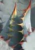
to which Ryan commented "what do you think?". What do I think, "we are going to get scratched and poked but let's go". It was bad but the game trails made it better than it could have been. Found a really nice spot about half way across the ridge to have lunch and refuel which made the second half of the off trail section seem like a breeze. On our way down Peters Trail we checked out Kane Spring which is about 3/4 full.

On a side note, regarding last nights playoff game, I suspect the half-time speech went something like this, "Larry, do not let us lose this game". Thank-you Fitz!
 Named place
 Named place [ checklist ]
[ checklist ]  Kane Spring

water 1 out of 5water 2 out of 5water 3 out of 5water less than max Cedar Basin Canyon Medium flow Medium flow

water 1 out of 5water 2 out of 5water 3 out of 5water 4 out of 5 Kane Spring Gallon + per minute Gallon + per minute
3/4 full.
_____________________
Expect to self rescue
 
Mar 22 2014
avatar

 Guides 6
 Routes 183
 Photos 5,612
 Triplogs 1,647

male
 Joined Mar 12 2004
 Scottsdale, AZ
Hoolie Bacon - Peters Trail LoopPhoenix, AZ
Phoenix, AZ
Hiking avatar Mar 22 2014
John9LTriplogs 1,647
Hiking23.25 Miles 4,417 AEG
Hiking23.25 Miles
4,417 ft AEG
 
Big loop with Kyle. Went counter clockwise and saw six people all day.
_____________________
 
average hiking speed 2.29 mph
1, 2, 3  Next

WARNING! Hiking and outdoor related sports can be dangerous. Be responsible and prepare for the trip. Study the area you are entering and plan accordingly. Dress for the current and unexpected weather changes. Take plenty of water. Never go alone. Make an itinerary with your plan(s), route(s), destination(s) and expected return time. Give your itinerary to trusted family and/or friends.

helpcommentissue

end of page marker