|
| | | |
| |
|
| Hiking | 8.25 Miles |
2,184 AEG |
| | Hiking | 8.25 Miles | 6 Hrs | | 1.38 mph |
| 2,184 ft AEG | | | | |
|
|
| |
| Linked |
|
none
[ show ]
| no linked trail guides |
| Partners |
|
none
[ show ]
| no partners | | Haven't hiked this trail since before the Juniper fire in 2016, so I was curious to see how it was recovering and I guessed (correctly) that it would be remote enough for some 2020-style social distancing, too. It's in decent shape overall, but seemed worth leaving a report for future hikers. So, dear future hikers: Here's a report for you!
First: The trailhead parking area might be easy to miss. It's on the right side of 288, just before a sharp turn and just past a closed road on the left (Road is #2770 according to the map, but it's not signed as far as I noticed). There is a wooden sign at the base of the trail but you probably can't see it from the road, especially if you're looking for a big painted sign like for the other trailheads. But it's a decent sized parking area with room for several cars (although we had it all to ourselves this day).
Okay! We've parked. Now let's hike! The hike starts straight uphill on an old Jeep road (a.k.a. Cienega Trail). Note: Cienega Trail is outside the Wilderness boundary and there were some fairly fresh ATV tracks on that section, so it's good to be aware of that possibility. I've seen hunters along there, too, during hunting season. That portion of the trail is in decent shape and, despite some evidence of the recent fire, still has plenty of tree cover for shade. We saw some warblers (Grace's and Yellow-rumped), as well as Western bluebirds, and a wild turkey (watch out for hunting season, turkey!).
Once on #146 itself, however, the trail is a bit more eroded and rockier than I recall——although exactly as steep as I remember.  The first mile or so above the junction was pretty heavily burned and the former shade trees are just dead snags now, so there's a lot of sun exposure. I was glad I had a hat. It's still pretty, though, with manzanita and scrub oak providing some green, and quite a few wildflowers blooming. And, of course, the views are more expansive now, so that's a benefit. There's quite a bit of deadfall on that mile+ of the trail, although it's easy enough to go over or around. Once up on top of the mountain, the trail levels off and there is very little evidence of fire and things are a lot easier. The tree cover is intact, so there's plenty of shade, and we saw lots of butterflies (Common Buckeye, Tiger Swallowtail, Arizona Sister), birds (mountain chickadees, juniper titmouse, white-breasted nuthatch, brown creeper, summer tanager, various woodpeckers) as well as one white-tailed deer and one mule deer——both does. Quite a lot of company up there! The first mile or so above the junction was pretty heavily burned and the former shade trees are just dead snags now, so there's a lot of sun exposure. I was glad I had a hat. It's still pretty, though, with manzanita and scrub oak providing some green, and quite a few wildflowers blooming. And, of course, the views are more expansive now, so that's a benefit. There's quite a bit of deadfall on that mile+ of the trail, although it's easy enough to go over or around. Once up on top of the mountain, the trail levels off and there is very little evidence of fire and things are a lot easier. The tree cover is intact, so there's plenty of shade, and we saw lots of butterflies (Common Buckeye, Tiger Swallowtail, Arizona Sister), birds (mountain chickadees, juniper titmouse, white-breasted nuthatch, brown creeper, summer tanager, various woodpeckers) as well as one white-tailed deer and one mule deer——both does. Quite a lot of company up there!
The sections of trail going across the mountain top, down and up the ravine, and out along the ridge to the promontory were all in good shape. However this trail doesn't see much human traffic (which is great!), and the pine needle carpet is pretty resilient, so there's rarely a clear footpath to follow. Instead you need to either be great with a map and compass, or just follow the large and plentiful cairns, which are easy to spot and very reliable, although deadfall may obscure a stack here or there. Just do a little recon and you'll find them again. They're pretty close together, so you shouldn't have to look far.
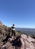
The promontory made a great lunch spot, with the view of Elephant Rock and some Claret cup hedgehog cacti blooming for a bonus. I wished I'd brought a hammock to put up on the ridge for a post-lunch nap, but I didn't (such an amateur!), and we were on a bit of a schedule anyway, so we returned the way we came. I was very glad for trekking poles on the way back down, as the trail is steep, loose, and rocky——the trifecta of potential ankle injuries! But we had no incidents and thus were able to spend a little extra energy clearing some of the deadfall off the trail. (Much better than BEING the deadfall on the trail.  ) )
The whole trip was about 6 hours at a fairly relaxed pace, with stops for bird-watching, plant IDs, and lunch. Bonus: we were the only people on the trail. |
|
Wildflowers Observation Moderate
Manzanita, Southwestern lewisia, fleabane, Indian paintbrush, claret cup hedgehog cacti, and others. |
|
| | |
|
|
|
 Route Editor