|
| | | |
| |
|
| Backpack | 16.25 Miles |
2,330 AEG |
| | Backpack | 16.25 Miles | 2 Days | | |
| 2,330 ft AEG | | | | |
|
|
| |
| Linked |
|
none
[ show ]
| no linked trail guides |
| Partners |
|
none
[ show ]
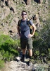
| no partners | | Solo backpacking is an experience unlike any other. A man and his thoughts... self reliance and awareness. An amazing retreat for clarity and contemplation. The Marsh Valley Loop has been on my list for awhile, and I figured this would be a good choice since it's nearby many other areas I've already visited, pretty far out, yet a new experience.
Gorgeous, very warm weekend in the Supes. Water water everywhere from recent rainfall and especially the previous weekend. Did the loop clockwise and tried to follow many of the sights highlighted in Carlson's & Stewarts Guide to the Superstition Wilderness. (great book, crazy to follow at times). Saw a couple other big groups of people in the beginning, and once I was away from them there was good solitude until near the end of the loop.
I tried to find the holding corral and old camp nearby the junction of Cavalry Trail and La Barge Creek. Apparently there are 4' wide walls I was unable to find. Anyone else have better luck? Was still fun stomping around off trail hunting for mysterious things. But exhausting.
Then I went partly up Squaw Canyon. Tried to find any evidence of the old Z Trail that Crazy Jake apparently used. Didn't find much for a trail, but it was a beautiful vantage point. On the way back a 7' monument is described, and I did find a huge rock cairn, perhaps 3' tall. Not sure if that's what they meant, but I enjoyed finding something significant that far off track.
Dropped pack and set up camp nearby Cavalry and Dutchman junction. Then took off for Charlebois spring which I've never been to. Frogs all around, cool to see a turtle splash down in the water. Again, tried to find the petroglyphs described right nearby, but no luck. The book says they're even signed. Must have been delusional from a long day on the trail. Oh well, it gives me a future goal.
Nice camp. Surprising how fast the cold settles in after sunset. Heard a roaring/screaming sound before going to bed. My best guess is a big cat mating call... mountain lion? Unsettling to say the least, but pretty far away. There was a responding call as well.
Sleep, yoga, more exploring. I WAS successful in finding the massively long rock wall nearby the wash down from the Dutchman and Cavalry junction. Very impressive. Then tried to find the old prospector's claim sign 6+5 up above. To no avail of course. Off-trail hiking becomes super strenuous and exhausting, physically and mentally. I did find what I thought was the horse trail shortcut nearby that area.
Went up Bull Pass trail and Black Top Mesa on the way home. Probably did over 20 miles all said and done. Overall amazing trip. Supes never disappoint. Gorgeous. Concerning how warm it was for February. Achilles really sore afterwards though unfortunately, so I might have overdone it :-P Until next time... |
  |
Boulder Creek - Superstition WA |
Medium flow |
Medium flow |
| | | for the Superstitions, a medium flow is a lot of water. Heavy rains consistently over the previous weekend really helped the situation everywhere. | | _____________________
| | |
|
|
|
 Route Editor