username
X
password
register
for free!
help
ArticlesGuidesRoutes
 
Photosets
 
 Comments
triplogs   photosets   labels comments more
Wishbone Junction - Goldfields Mtns - 7 members in 23 triplogs have rated this an average 3 ( 1 to 5 best )
1, 2  Next
23 triplogs
login for filter options
Feb 04 2023
avatar

 Guides 1
 Routes 14
 Photos 7,202
 Triplogs 5,208

68 male
 Joined Mar 16 2008
 chandler,az
Golden Dome, AZ 
Golden Dome, AZ
 
Hiking avatar Feb 04 2023
johnlpTriplogs 5,208
Hiking12.58 Miles 2,907 AEG
Hiking12.58 Miles   8 Hrs   19 Mns   1.70 mph
2,907 ft AEG      54 Mns Break
 no routes
1st trip
Kelly and I have been wanting to hike Golden Dome for a few years now. Today was the day.
Got started before sunrise. Warmer than expected. 54 degrees at the trailhead. Much cooler in places.
The scenery here in the Goldfields is always fantastic, start to finish.
Before long we reached Pedestal Arch. Cool spot. A lot of work from there to Golden Dome. The ascent wasn't bad, only one spot that was a little exposed. Views from the top are excellent.
Descending was tedious down loose steep terrain. Going through the canyons and pools of running water was special.
Long day by the time we finished up. Great hike. Thanks Kelly. :)
 Named place
 Named place [ checklist ]
[ checklist ]  Golden Dome- 3185ft
wildflower observationwildflower observationwildflower observationwildflower observationwildflower observation
Wildflowers Observation Isolated
_____________________
“Good people drink good beer.” Hunter S Thompson
 
Feb 04 2023
avatar

 Guides 10
 Routes 673
 Photos 7,281
 Triplogs 4,660

67 female
 Joined Nov 17 2008
 phoenix, az
Golden Dome, AZ 
Golden Dome, AZ
 
Hiking avatar Feb 04 2023
trekkin_geckoTriplogs 4,660
Hiking12.40 Miles 2,828 AEG
Hiking12.40 Miles   8 Hrs   20 Mns   1.64 mph
2,828 ft AEG      47 Mns Break
 
1st trip
Route Scout Route Recorded  on Route Scout | Pop | Map | Popup | MapDEX
john and i have had golden dome on our must do list for a few years
we decided to get up there today
got going around 0700
followed @dixieflyer's route for most of the hike
immediately scenic from milepost 204
followed a few trails that we've been on before for about 3.5 miles
off trail to our first landmark, pedestal arch, which i've seen at least three times
then the ridgeline up to golden dome saddle
we took one of the west side chutes for climb to the summit
one corner had some exposure
nice to be up top after seeing it on every goldfields hike
we took a snack/photo break and signed the register
i was a little sketched out before the descent, but it was fine
thank you for spotting me, john
we then followed the ridgeline over peak 3141
the downhill from there was slow going - steep with loose rock
the worst part of the entire hike was the drainage we followed to get over to triple arch and black glass canyon
lots of catclaw and other sticker bushes
saw the arch and dropped down the canyon
one bypass and fun downclimbing
water flowing and some deep pools
once out of the canyon, we took the road back partway, then some other trails before closing the loop
four classic goldfield landmarks on this hike
water in some of the drainages
great views from the high points
a lot of bang for the buck
it's not easy with all the off trail
we had a good day for it
copied linkage since i still have no idea what trails we were on
thanks lp! this was a good one :)
_____________________
hazhole
  2 archives
Sep 14 2022
avatar

 Guides 8
 Routes 70
 Photos 3,208
 Triplogs 273

59 male
 Joined Oct 07 2017
 Chandler, AZ
Wishbone Junction - Goldfields MtnsPhoenix, AZ
Phoenix, AZ
Hiking avatar Sep 14 2022
YoderTriplogs 273
Hiking6.30 Miles 1,250 AEG
Hiking6.30 Miles   2 Hrs   59 Mns   2.33 mph
1,250 ft AEG      17 Mns Break10 LBS Pack
 no routes
1st trip
Linked   none no linked trail guides
Partners none no partners
Didn't follow this trail all the way. Was lucky enough to spot a grey fox.
 Fauna
 Fauna [ checklist ]
[ checklist ]  Gray Fox
_____________________
J. Yoder
 
Nov 25 2019
avatar

 Routes 268
 Photos 2,969
 Triplogs 541

66 male
 Joined Aug 16 2009
 Mesa,AZ
Wishbone Junction - Goldfields MtnsPhoenix, AZ
Phoenix, AZ
Hiking avatar Nov 25 2019
hikerdwTriplogs 541
Hiking5.81 Miles 725 AEG
Hiking5.81 Miles
725 ft AEG
 
no photosets
1st trip
Linked   none no linked trail guides
Partners partners
easyhiker
Back out to the Goldfields, this time with Kelley. Actually saw more hikers today on a Monday than we saw on Saturday. At the trailhead I parked next to a newer Tacoma, cement color, that was displaying the Hikearizona sticker. Could that have been @DixieFlyer ?
_____________________
Expect to self rescue
 
Nov 24 2019
avatar

 Routes 28
 Photos 1,221
 Triplogs 27

71 male
 Joined Jan 14 2009
 Kodiak, AK
Goldfields Meander, AZ 
Goldfields Meander, AZ
 
Hiking avatar Nov 24 2019
mr_squishyTriplogs 27
Hiking
Hiking
 
1st trip
A pleasant day of hiking on trails and washes in the vicinity of the Rte 88 MP 204 trailhead. Lots of water, saw one other hiker and one ORV.
_____________________
Posted from my turquoise Princess rotary dial phone.
  4 archives
Nov 22 2019
avatar

 Routes 28
 Photos 1,221
 Triplogs 27

71 male
 Joined Jan 14 2009
 Kodiak, AK
Goldfields Golden Dome and Peak 3141, AZ 
Goldfields Golden Dome and Peak 3141, AZ
 
Hiking avatar Nov 22 2019
mr_squishyTriplogs 27
Hiking
Hiking
 
1st trip
I'd had dixieflyer's GPS track in my "to do" folder for some time and Nov 22 was the day for it. I was on the trail before sunrise at 6:15 am and ended up taking twelve hours and returning to the trailhead at 6 pm in the dark. I like to take my time and look around and I move fairly deliberately when rock/boulder hopping. I chose to do the hike counterclockwise which probably was not a good decision. I think going clockwise is probably a bit easier in the long run. Due to the large amounts of water in Black Glass Canyon up from the Jeep wash, the going was slow as I had to go around areas one could normally hike in. The arches were spectacular, the summits had outstanding views, and route was difficult with some fun bushwhacking. It was nice to be on a trail when it got dark. Exactly 0.0 people and 0.0 ORVs were encountered on this hike. I will upload the gpx file soon, but it's pretty much identical to dixieflyer's. With the heavy rains earlier in the week, there was lots of water everywhere.
_____________________
Posted from my turquoise Princess rotary dial phone.
  3 archives
Mar 24 2019
avatar

 Guides 1
 Routes 14
 Photos 7,202
 Triplogs 5,208

68 male
 Joined Mar 16 2008
 chandler,az
Pedestal Arch, AZ 
Pedestal Arch, AZ
 
Hiking avatar Mar 24 2019
johnlpTriplogs 5,208
Hiking10.40 Miles 2,098 AEG
Hiking10.40 Miles   6 Hrs   16 Mns   1.87 mph
2,098 ft AEG      43 Mns Break
 no routes
1st trip
Another foray into the delightful Goldfields. I'm starting to recognize some of the places I've been before. Hiking off trail was looser and brushier than usual for this area. Got a little scratched up, but nothing worth wearing pants for.

Flowers are still looking good. The geology here is relentlessly interesting and great for hiking.

A 29 year old joined us, and a 79 year old left us. :lol: Always a pleasure to hike with Ray and Kelly. Rhonda joined us for lunch and reminded us how compassionate Ray is. Though the other half of the story is much more interesting.

Good times. Thanks you two. :)
wildflower observationwildflower observationwildflower observationwildflower observationwildflower observation
Wildflowers Observation Moderate
_____________________
“Good people drink good beer.” Hunter S Thompson
 
Mar 24 2019
avatar

 Guides 10
 Routes 673
 Photos 7,281
 Triplogs 4,660

67 female
 Joined Nov 17 2008
 phoenix, az
Pedestal Arch, AZ 
Pedestal Arch, AZ
 
Hiking avatar Mar 24 2019
trekkin_geckoTriplogs 4,660
Hiking10.10 Miles 2,051 AEG
Hiking10.10 Miles   6 Hrs   16 Mns   1.82 mph
2,051 ft AEG      43 Mns Break
 
1st trip
this hike was an attempt to summit golden dome, following routes posted by @chumley and @dixieflyer
two peaks, two arches and a trip down black glass canyon are featured
got an early start and enjoyed the trails to wishbone junction
(i just learned exactly where this is, according to tenny's gps coordinates)
a bit in the wash, then the off trail began
pretty good bushwhack uphill on loose rock, not terrible but time-consuming
vegetation seems a little more overgrown than usual this spring
finally made it to pedestal arch
there is definitely an easier way to get to this point
ray wasn't feeling the peaks, and he wanted to cut the route and meet us near black glass canyon
i wasn't comfortable at all with us splitting up, so we descended from there
upon further review, it might have been nice to cut over to black glass canyon
looks like there is a [ gps route ] for that option
after dropping back down we still had to get back to our trail, so we got to experience an off trail "shortcut" :)
nice day, good company, always fun to be out in the goldfields
i'm gradually learning some of the trail names and landmarks
ray treated us to lunch at the gecko grill in gilbert - thank you!
i had the grilled gecko :lol:
enjoyed meeting rhonda
we'll try again with a different route to pedestal arch, but maybe not this spring
golden dome will still be there
another thought is to take black glass canyon up to 3141, over to golden dome and return the same way
no need to see pedestal arch a third time
kudos to those who completed this loop; it's a good one
nice to be out with ray and john again
 Culture
 Culture [ checklist ]
[ checklist ]  HAZ Food
_____________________
hazhole
  1 archive
Mar 24 2019
avatar

 Guides 1
 Routes 447
 Photos 4,407
 Triplogs 938

68 male
 Joined Mar 09 2012
 Gilbert, AZ
Pedestal Arch, AZ 
Pedestal Arch, AZ
 
Hiking avatar Mar 24 2019
rayhustonTriplogs 938
Hiking10.10 Miles 1,998 AEG
Hiking10.10 Miles   6 Hrs   16 Mns   1.82 mph
1,998 ft AEG      43 Mns Break
 no routes
1st trip
I'm going to piggy back off of Kelly's triplog, which sums up our day very nicely. Thank you Kelly and John, again, for your patience and understanding. One of these days we'll get it right.

Despite not achieving our objective, it's always a great day when you're hiking in the Goldfields. I came back whooped and scratched, but those are minor inconveniences compared to great company and wonderful scenery.
_____________________
 
Feb 06 2019
avatar

 Guides 99
 Routes 1,484
 Photos 16,072
 Triplogs 1,374

male
 Joined Jan 07 2017
 Fountain Hills,
Goldfields: Golden Dome and Peak 3141, AZ 
Goldfields: Golden Dome and Peak 3141, AZ
 
Hiking avatar Feb 06 2019
DixieFlyerTriplogs 1,374
Hiking13.70 Miles 3,309 AEG
Hiking13.70 Miles   10 Hrs   25 Mns   2.15 mph
3,309 ft AEG   4 Hrs   3 Mns Break
 
1st trip
Tracie, my intrepid hiking partner, had been wanting to go hike Black Glass Canyon, so we decided to go hike in the canyon and also check out a couple of peaks and a couple of arches.

I had seen a triplog and a GPS track that Chumley posted last month in which he climbed up Golden Dome and Peak 3141, so we decided to bag those as well. Along the way we also went to Pedestal Arch and viewed Triple Arch while in Black Glass Canyon.

We started and ended the hike at the Willow Canyon TH, which is at mile marker 204 on Highway 88. It was my first time to this TH.

The hike started out easy enough, but after 3 miles or so it became a total off-trail cross country bushwhack/scramble.

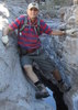
Our first stop was at Pedestal Arch, which was neat to see. We eventually made our way to Golden Dome, and climbed up it via the short chute that Chumley went up on the NW side of the Dome -- he picked a good route up. The views atop the Dome were really nice -- much better than being on Dome Mountain, the high point in the Goldfields. We descended the summit the same way that we came up, and then went over to Peak 3141. The climb up was easy, but the descent down the east side was steep and very slow going...but we eventually made our way down, and went over to Black Glass Canyon. I enjoyed the canyon, although there were a few tricky descents. While in the canyon we were able to see Triple Arch, although we didn't feel like climbing up to the arch. Once we got out of Black Glass Canyon, we started back in Rough-N-Rowdy Canyon and took a look at a few caves that were there.

After climbing these 2 peaks, I have now climbed atop 11 of the 17 highest peaks in the Goldfields. Maybe I will get the other 6 someday.

Before going up to Golden Dome, I briefly thought about checking out Tuff Dome. It might be a doable climb, but it looked pretty steep from a distance.

We didn't see any wildlife on the hike, but didn't see any other humans either. I guess that 1 out of 2 ain't bad!
_____________________
Civilization is a nice place to visit but I wouldn't want to live there
  4 archives
Mar 04 2017
avatar

 Guides 1
 Routes 169
 Photos 1,616
 Triplogs 218

81 male
 Joined Dec 16 2011
 Mesa,Az
Trans GoldfieldPhoenix, AZ
Phoenix, AZ
Hiking avatar Mar 04 2017
hikingaz2Triplogs 218
Hiking16.27 Miles 2,601 AEG
Hiking16.27 Miles   11 Hrs   13 Mns   1.78 mph
2,601 ft AEG   2 Hrs   4 Mns Break12 LBS Pack
 
1st trip
Started out to do a little Re-Con for a up coming hike that we've been eying for a couple of years. Which was the Trans Goldfield. Official Description very vague, and AZLOT69's triplog was only thing to go by. Got up to the top of Rhyodacite Canyon, stopped for a snack. I will say someone has trimmed and cairned this route, was so much nicer then 3 years ago. Thank you very much :) This is a beautiful Canyon and if you haven't been there, I would highly recommend this as go to hike. Lot of water running today :D :D Roger says we're this far, why don't we just head over to Route 88 :scared: :scared: :o :o All we had to do was get to the top of Goldfield Figure 8, and cruise down to the TH. ( Rog's famous last words ) we thought the top of the 8 was maybe 2 miles at the most. Called Iris -- Cel phone service :o :y: Changed our plans. Asked her to meet us at the Willow Springs TH at 5 to 5:30 at the latest. The route we wanted turned out not to be 2 miles but 4 miles of -- To quote AZLOT69 triplog --- "This will test your endurance and route finding skills" ---- : rambo : style. Amen !!! No Cel service, we had no actual route to follow, Now no way to contact anyone :sweat: new ETA 7 PM and Iris is waiting :sweat: :sweat: :scared: Glad she is :pray: very understanding. We had to go up thru a couple of saddles to check out the route from a higher view point, last saddle we went up got cliffed out , but looked below and found a ramp that took us back down to the wash. Be prepared for heavy brush and catclaw during your many crossings of the wash. This center 4 miles or so is the path of least resistance !!! You are in the sun most of the day, so plenty of water, rest and anything over 85 degrees I would think twice before attempting. Over all this was a great hike with views of the inner Goldfields seldom seen.
_____________________
 
Feb 15 2017
avatar

 Guides 177
 Routes 249
 Photos 10,213
 Triplogs 2,215

74 male
 Joined Feb 12 2002
 Gold Canyon, AZ
Wishbone Junction - Goldfields MtnsPhoenix, AZ
Phoenix, AZ
Hiking avatar Feb 15 2017
AZLOT69Triplogs 2,215
Hiking7.00 Miles 330 AEG
Hiking7.00 Miles
330 ft AEG
 no routesno photosets
Linked   none no linked trail guides
Partners none no partners
I was surprised when I found no other vehicles at the traihead. Made for a pleasant day.
_____________________
It's best for a man to remain silent and be thought a fool, than to open his mouth and remove all doubt.
--Mark Twain
 
Jan 27 2017
avatar

 Guides 1
 Routes 169
 Photos 1,616
 Triplogs 218

81 male
 Joined Dec 16 2011
 Mesa,Az
Wishbone Junction - Goldfields MtnsPhoenix, AZ
Phoenix, AZ
Hiking avatar Jan 27 2017
hikingaz2Triplogs 218
Hiking8.52 Miles 1,559 AEG
Hiking8.52 Miles   5 Hrs   25 Mns   2.28 mph
1,559 ft AEG   1 Hour   41 Mns Break12 LBS Pack
 
1st trip
Linked   none no linked trail guides
Partners partners
RofRandR
Roger's Son Brett was in town for a few days, and wanted a scenic Hike, say no more, Goldfields here we come. This is such a nice area to hike with so many variations it's unreal :y:
_____________________
 
Nov 05 2016
avatar

 Routes 268
 Photos 2,969
 Triplogs 541

66 male
 Joined Aug 16 2009
 Mesa,AZ
Razorback KnobPhoenix, AZ
Phoenix, AZ
Hiking avatar Nov 05 2016
hikerdwTriplogs 541
Hiking9.14 Miles 1,943 AEG
Hiking9.14 Miles   5 Hrs   33 Mns   1.90 mph
1,943 ft AEG      45 Mns Break
 
1st trip
Partners none no partners
Hiked in from the Willow Springs trailhead. Saw lots of standing water on the way to Wishbone Junction from the recent rains. The off trail portion of the hike to the Knob and Camouflage Tanks wasn't that bad other than some loose granite which made it easy to slip (one good fall down the chute) and some areas with ankle buster sized rocks that we hiked through. Saw one deer two different times (my guess). Only saw a group of 4 horse back riders all day. Fantastic hike in the Goldfields.
_____________________
Expect to self rescue
 
Aug 31 2016
avatar

 Guides 13
 Photos 15,617
 Triplogs 323

male
 Joined Oct 23 2010
 mesa
Wishbone Junction - Goldfields MtnsPhoenix, AZ
Phoenix, AZ
Hiking avatar Aug 31 2016
gummoTriplogs 323
Hiking7.00 Miles 330 AEG
Hiking7.00 Miles
330 ft AEG
 no routes
1st trip
Linked   none no linked trail guides
Partners none no partners
Unless I was at the wrong "trailhead" I like to change the description being trail finding skills to 5 out of 5 and 99% bushwhacking with a 1% margin of error. I pretty much gave up on the trail and did my own thing. It rained last night there, but didn't rain where I was at. The rain drew the snakes out, and I, like a good HAZ hiker, cashed in. :D My snake total is up to 261. I finally saw a baby dback locally.
_____________________
 
Mar 30 2016
avatar

 Photos 21
 Triplogs 2

75 female
 Joined Jul 09 2013
 Apache Junction,
Wishbone Junction - Goldfields MtnsPhoenix, AZ
Phoenix, AZ
Hiking avatar Mar 30 2016
coloradofoxtrotTriplogs 2
Hiking6.30 Miles 1,100 AEG
Hiking6.30 Miles
1,100 ft AEG
 no routes
1st trip
Linked   none no linked trail guides
Partners none no partners
This was a beautiful hike to finish off my winter season in Apache Junction. Beautiful views.
_____________________
 
Feb 19 2014
avatar

 Guides 4
 Routes 8
 Photos 159
 Triplogs 13

74 male
 Joined Mar 05 2011
 Florence, AZ
Wishbone Junction - Goldfields MtnsPhoenix, AZ
Phoenix, AZ
Hiking avatar Feb 19 2014
bensondkTriplogs 13
Hiking8.70 Miles 761 AEG
Hiking8.70 Miles   5 Hrs   2 Mns   1.73 mph
761 ft AEG10 LBS Pack
 
Linked   none no linked trail guides
Partners none no partners
I led a group of hikers from Sun City Anthem at Merrill Ranch hiking club, and had a very enjoyable hike. We did the loop counterclockwise in order to do the sand portion going downhill. The sand lasts for about 3 miles, and is much like walking on a beach - good exercise, but tiring. Once past the sand, and beginning the uphill portion at N33 31.870 W111 29.792, the route becomes more scenic, with rugged canyon walls. The caves at N33 31.748 W111 29.874 were definitely the highlight for the group.
wildflower observationwildflower observationwildflower observationwildflower observationwildflower observation
Wildflowers Observation Isolated
there were some flowers, but limited rain is leading to limited flowers.
_____________________
 
Dec 09 2013
avatar

 Guides 4
 Routes 8
 Photos 159
 Triplogs 13

74 male
 Joined Mar 05 2011
 Florence, AZ
Wishbone Junction - Goldfields MtnsPhoenix, AZ
Phoenix, AZ
Hiking avatar Dec 09 2013
bensondkTriplogs 13
Hiking7.00 Miles 330 AEG
Hiking7.00 Miles   6 Hrs   42 Mns   1.04 mph
330 ft AEG
 
Linked   none no linked trail guides
Partners none no partners
We approached this hike expecting to do a lot of bushwhacking, and found it to be a hike with mostly easy terrain and fabulous scenery. We did the loop in a clockwise direction which put the best scenery in the first part. I will include a GPS track of this route in the route list, and also a set of photos under the same name. Most of the way is quite well defined trail worn in by horses. This first half mostly follows streambed, with some boulders, some water, and large caves worth exploring. The rugged walls to the valley just after Wishbone Junction are awesome viewing, but very difficult to capture the feeling with a camera. The second half of the loop is easy walking on a road/streambed with lots of sand, similar to walking on a beach. It would be nice to find an alternate route for the return to the trailhead, but there were no apparent good choices that I have seen yet, unless bushwhacking is your choice.
Both sets of caves, marked by waypoints included with the GPS track, are worth stopping and touring through them. The first set is particularly interesting because they are large and have more than one entrance. It is easy to imagine these caves may have been homes thousands of years ago.
foliage observationfoliage observationfoliage observationfoliage observationfoliage observation
Autumn Foliage Observation None
No autumn foliage seen.
_____________________
 
Jan 24 2011
avatar

 Guides 14
 Routes 71
 Photos 474
 Triplogs 71

male
 Joined Nov 24 2006
 Mesa, AZ
Wishbone Junction - Goldfields MtnsPhoenix, AZ
Phoenix, AZ
Hiking avatar Jan 24 2011
sventreTriplogs 71
Hiking7.00 Miles 330 AEG
Hiking7.00 Miles
330 ft AEG
 
no photosets
1st trip
Linked   none no linked trail guides
Partners none no partners
Thought I would make an attempt to reach an "unnamed" set of structures which appear at 33 31'25.12"N 111 30'35.95"W on Google Earth. My plotted course didn't pan out and I will need to make another attempt to mount the ridge at some point north of the Junction. In the meanwhile I spent the morning exploring the heart of the Goldfields and Cottonwood Spring.
_____________________
 
Jan 02 2010
avatar

 Guides 177
 Routes 249
 Photos 10,213
 Triplogs 2,215

74 male
 Joined Feb 12 2002
 Gold Canyon, AZ
Wishbone Junction - Goldfields MtnsPhoenix, AZ
Phoenix, AZ
Hiking avatar Jan 02 2010
AZLOT69Triplogs 2,215
Hiking10.00 Miles 780 AEG
Hiking10.00 Miles   5 Hrs      2.00 mph
780 ft AEG
 no routesno photosets
Linked   linked  
Partners partners
borealisbiker
It doesn't get much better than this. Great day on the trail. Near the end ran into fellow Haz member and gave her a guided tour of Little Chance Canyon. Great time.
_____________________
It's best for a man to remain silent and be thought a fool, than to open his mouth and remove all doubt.
--Mark Twain
 
average hiking speed 1.85 mph
1, 2  Next

WARNING! Hiking and outdoor related sports can be dangerous. Be responsible and prepare for the trip. Study the area you are entering and plan accordingly. Dress for the current and unexpected weather changes. Take plenty of water. Never go alone. Make an itinerary with your plan(s), route(s), destination(s) and expected return time. Give your itinerary to trusted family and/or friends.

helpcommentissue

end of page marker