username
X
password
register
for free!
help
ArticlesGuidesRoutes
 
Photosets
 
 Comments
triplogs   photosets   labels comments more
Webb Peak from Ash Creek TH - 22 members in 73 triplogs have rated this an average 3.8 ( 1 to 5 best )
1, 2, 3, 4  Next
73 triplogs
login for filter options
Sep 28 2024
avatar

 Guides 1
 Routes 14
 Photos 7,202
 Triplogs 5,208

68 male
 Joined Mar 16 2008
 chandler,az
Riggs - Clark - Cunningham - Webb - Ice Cave, AZ 
Riggs - Clark - Cunningham - Webb - Ice Cave, AZ
 
Hiking avatar Sep 28 2024
johnlpTriplogs 5,208
Hiking14.00 Miles 2,600 AEG
Hiking14.00 Miles
2,600 ft AEG
 no routes
1st trip
Day two n the Pinalenos. Drove to Riggs Lake to get started. Hiked around the lake then up to Clark Peak. Nice hiking and views.
We then drove to do the Cunningham Loop. We didn't realize a big chunk had gone unmaintained since the fire. We took the path of least resistance and completed a nice loop anyway.
Next up was Webb Peak. Finally, after hanging out in camp a few hours, we headed out to the infamous ice caves. We found a few caves, lost a phone for a bit, and made it back in one piece. Big day! :)
_____________________
“Good people drink good beer.” Hunter S Thompson
 
Sep 28 2024
avatar

 Guides 10
 Routes 673
 Photos 7,281
 Triplogs 4,660

67 female
 Joined Nov 17 2008
 phoenix, az
Riggs - Clark - Cunningham - Webb - Ice Cave, AZ 
Riggs - Clark - Cunningham - Webb - Ice Cave, AZ
 
Hiking avatar Sep 28 2024
trekkin_geckoTriplogs 4,660
Hiking14.00 Miles 2,600 AEG
Hiking14.00 Miles
2,600 ft AEG
 no routes
1st trip
day two in the pinalenos
coffee and breakfast, then we drove up to riggs lake
bruce had a loop that took off from the west side of riggs flat lake, then some off trail and forest service roads to clark peak trail
a little brushy but not the locust fest we were warned about
decent views from the peak
returned to the east side of the lake via forest service roads
next up was cunningham loop
we started off counterclockwise on the loop, which was along an old roadbed
at two miles, we found that the connection with the southeast loop was pretty much obliterated
one climb to a higher roadbed as we finished the western portion of the loop
nice hike with good views below
lots of slash piles, some right on the trail
had plenty of time to do the webb peak loop
the tower is still there, but just the steel framework remains of the lookout
finished via the road
a stop at the visitor center, then hung out at camp for awhile
late afternoon trip to try and find the ice caves
we found one that john and i had been to eight years ago, then scrambled around the hillside looking for more
noticed i no longer had my phone in my pocket, which was a bit stressful
bruce was able to call my phone, and we could hear it as i retraced the route i had taken
found it sitting on top of a boulder, thank goodness
backpacker meals for dinner and another fire made for a nice evening
 Culture
 Culture [ checklist ]
[ checklist ]  Benchmark
_____________________
hazhole
  1 archive
Sep 28 2024
avatar

 Guides 41
 Routes 1,626
 Photos 14,983
 Triplogs 2,760

69 male
 Joined Jan 20 2009
 Far NE Phoenix,
Riggs - Clark - Cunningham - Webb - Ice Cave, AZ 
Riggs - Clark - Cunningham - Webb - Ice Cave, AZ
 
Hiking avatar Sep 28 2024
The_EagleTriplogs 2,760
Hiking14.81 Miles 2,562 AEG
Hiking14.81 Miles   7 Hrs   24 Mns   2.64 mph
2,562 ft AEG   1 Hour   47 Mns Break
 
1st trip
Route Scout Route Recorded  on Route Scout | Pop | Map | Popup | MapDEX
Riggs Lakeshore Trail #340

We started our day around 7:30 a.m. at Riggs Lake. It was my first time there, and it’s a pretty little lake. There were a few fishermen and kids wandering from their campsites, beginning to stir for the day. Heading clockwise, we followed a use trail to a two-track road and ultimately reached the Clarke Peak Trailhead.

Clark Peak

John's girlfriend Denise at the Columbine Visitor Center had warned us that this trail was terribly overgrown with locust trees and not worth hiking. However, we weren’t in the listening mood and decided to give it a try anyway. The rumors of locusts were highly exaggerated. John and Kelly both hiked in shorts and short sleeves with little to no bloodshed. The trail is tight in spots, and there are multiple paths heading up the mountain. This is a worthwhile trail to explore when in the Riggs Lake area.

CP Flat Loop

This loop is located entirely on the far western section of the Swift Trail and 4x4 road. It’s mainly wooded, with some impressive views along the Swift.

Cunningham Loop Trail #316

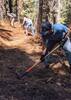
Next up was the official loop found here. Starting from the Cunningham Campground parking lot, we made our way around counterclockwise to the intersection with the "Lower" portion of the loop. Evidence of the fire was abundant, but not everything had been torched. A significant amount of work has been done to open this portion of the loop. There are literally hundreds of slash piles stacked along sections of the trail. At about the 2-mile mark, we reached the intersection with the "Lower" Trail. Things changed quickly; this section is a warzone. We aborted our attempt there and opted to complete just the "Upper" portion. Later, while talking with a volunteer at the visitor center, we learned that the lower portion was severely damaged by the Frye Fire and may never be rebuilt.

Webb Peak Loop via Columbine TH

Since we had some extra time, we decided to do this loop. Starting from the Columbine Trailhead, we headed uphill through the burn area and the now 2-foot tall aspen. The fire tower still stands but is charred. We continued down the lookout road and back to the parking area, where John made another new friend. He thought he’d have her eating out of his hand with his sweet-talking, but she had no part of it.

Ice Cave

We returned to camp for a bit, had some lunch, relaxed, and then set out in search of the "Ice Cave."

It was just a short walk from our campsite. Kelly had a waypoint, and I had a waypoint from an online search, so we wandered about looking for other possibilities. We found three potential sites.

The first was easy to find, just about 50 feet into the mountain, but I didn't think it was the right one.

The second one, John descended into a bit before the bats chased him out. This cave dropped straight down pretty steeply, and I ultimately believe this is the one we were looking for.

The third cave was a bit more adventurous to reach. Kelly, John, and I took two different routes through the boulder fields, searching for possibilities. I found one that you could enter, which contained at least one large room measuring approximately 20 by 20 feet.

While Kelly was making her way over to us through the mass of boulders, we heard a “Oh Schmidt!” (or something like that). She’d lost her phone somewhere, and it could have been anywhere, including 50 feet straight down among the boulders. John tried calling it, but we heard nothing. We all worked our way back to where she’d come from. I tried calling it, and BINGO—we heard it! She was lucky to find it sitting right on top of a rock.
 Culture
 Culture [ checklist ]
[ checklist ]  Benchmark
_____________________
There is a very fine line between "hobby" and "mental illness."
Dave Barry 🦅
  3 archives
Jul 14 2024
avatar

 Routes 31
 Photos 4,724
 Triplogs 187

50 male
 Joined Mar 14 2016
 Gold Canyon, AZ
Jacobson SawmillTucson, AZ
Tucson, AZ
Hiking avatar Jul 14 2024
00blackoutTriplogs 187
Hiking5.39 Miles 1,152 AEG
Hiking5.39 Miles
1,152 ft AEG
 no routes
1st trip
Linked   linked  
Partners none no partners
Headed down south yesterday to one of my favorite summer getaways, the Pinaleno Mountains. Had a couple of different hikes in mind, so I started with the lower elevation one first knowing it would be warmer as the day progressed. Parked at the Cluff Dairy Rec site and headed down the old road. The first stop was at the old Cluff Dairy site. Tons of old concrete foundations and stone walls left. Continued down on an old wagon road to the Jacobson Sawmill site. Pretty thick veg down at the old site, almost PNW-like.Had a couple of ravens having a pretty vocal argument while I was down there, which added some :scared: to the site. Some old relics are scattered throughout the site, which I checked out before returning. Back at the truck, I continued up the mountain parking at the Ash Creek TH, where the temperature was a cool 66 degrees when I started down Ash Creek. This trail was recently cleared last year to the junction and it was in pretty good shape; a couple of minor pieces of deadfall and the raspberry bushes are growing back but it's good for the time being. Water was flowing nicely in Ash Creek as I reached the junction and started the initial climb. The 2017 Frye Fire destroyed pretty much all of the pine trees in this area, however, the Aspens are coming back in groves, literally thousands of them. Even though the temps were in the 70's the sun was hot and it was pretty warm on the climb up. Once I reached the peak the clouds came in which cooled it off; the truck was reading 64 degrees on the drive out! Saw tons of deer and no people on the trails all day; overall there were not that many people up on the mountain today, which is perfect. The Pinalenos never disappoint.
wildflower observationwildflower observationwildflower observationwildflower observationwildflower observation
Wildflowers Observation Substantial

dry Twilight Creek Dry Dry
_____________________
Hiking is just walking where it’s okay to pee. :y:
 
Sep 19 2023
avatar

 Guides 4
 Photos 4,732
 Triplogs 2,607

55 male
 Joined Sep 29 2004
 Small Town USA
Webb Peak from Ash Creek THTucson, AZ
Tucson, AZ
Hiking avatar Sep 19 2023
SkyIslander18Triplogs 2,607
Hiking7.25 Miles 1,200 AEG
Hiking7.25 Miles
1,200 ft AEG
 no routes
Hardest hit area of the 2017 Frye Fire was the entire Webb Peak area.
95 percent tree mortality including the 1933 fire lookout tower.
After 6 years the outer trail has recently been redone all the way to the top.

We headed up to check it out parking at Columbine Corrals.
Hike - Down Ash Creek Trail :next: Up Webb Peak from Ash Creek :next: Lunch break under the lookout tower :next: Down Webb Peak Trail #345 to Columbine to complete the loop.
Basically you now hike through a 6 year old total burn area covered in dead grey pines with 6-20 foot aspens covering almost the entire forest floor. There were also ferns, wildflowers and a few green pines here and there. Kind of a surreal sight to see it like this, but wow ... this is going to be one hell of a great aspen forest in the coming years!
All the Webb trails are in great condition now, Ash Creek Trail below the T is a total disaster.

After our loop we drove back down the Swift Trail for a short hike up High Peak road to the old bottle dump I dug a few days earlier. Had an extra person to help me haul down some more of the cool bottles I uncovered. These old bottles will decorate our cactus gardens.

Webb Peak now looks completely different from all my younger days of hiking the area, but there is a new mysterious beauty to these burn areas that is starting to grow on me.

Happy to see this loop again and happy to see it with the person I hiked it with just before the fire.
:D
foliage observationfoliage observationfoliage observationfoliage observationfoliage observation
Autumn Foliage Observation Isolated
wildflower observationwildflower observationwildflower observationwildflower observationwildflower observation
Wildflowers Observation Moderate
_____________________
https://www.instagram.com/skyislander22/
 
Aug 22 2023
avatar

 Triplogs 18

53 male
 Joined Jun 08 2015
 Tucson
Webb Peak from Ash Creek THTucson, AZ
Tucson, AZ
Hiking avatar Aug 22 2023
SJFLTriplogs 18
Hiking3.50 Miles 900 AEG
Hiking3.50 Miles
900 ft AEG18 LBS Pack
 no routesno photosets
1st trip
Linked   none no linked trail guides
Partners none no partners
I did this late in the day. It's a super quick and straightforward hike straight to the fire tower. The aspens are growing in thick. And the fire damaged trees are lined up like matchsticks all along the beginning of the trail. There are lots of large burnt pines along the way. Some of them have an amazing and overbearing presence.

When I got to the top I walked around some of the burn at the top. As you head south, there are some high points that give you amazing, clear views to the south and west. There are no trails, but since you have the fire tower as a landmark, it's pretty hard to get lost.

This trail would make a great trail run for anyone that needed to pop out of one of the nearby campgrounds and get away for a quick workout fix.
wildflower observationwildflower observationwildflower observationwildflower observationwildflower observation
Wildflowers Observation Isolated
_____________________
 
Jul 17 2023
avatar

 Routes 2
 Photos 99
 Triplogs 24

male
 Joined Mar 29 2022
 Tucson, AZ
Webb Peak from Ash Creek THTucson, AZ
Tucson, AZ
Hiking avatar Jul 17 2023
gordee151Triplogs 24
Hiking3.50 Miles 900 AEG
Hiking3.50 Miles
900 ft AEG
 no routes
1st trip
Linked   none no linked trail guides
Partners none no partners
Trail was worked by AZ Healthy Forest Initiative Crews during mid July 2023. All dead fall should be out and trail has been benched with in most places a 3ft wide tread and 6 foot wide brush corridor. As this was a severe burn area the possibility for blow downs to occur remains high. While the trail is open and in it's best condition in years this is a remote area with primitive conditions and little use. Go prepared, Use caution. Interested in trail work or learning more about trails on Mt Graham? See contact details on my signature line.
_____________________
Sonoran Desert Mountain Bicyclists
Mt Graham Volunteer Trail Work Coordinator
Want to volunteer? Email: communications@sdmb.org
Instagram @sdmb_mtb
  4 archives
Sep 02 2022
avatar

 Guides 94
 Routes 840
 Photos 22,055
 Triplogs 1,993

52 male
 Joined Sep 18 2002
 Tempe, AZ
Webb Peak Trail #345Tucson, AZ
Tucson, AZ
Hiking avatar Sep 02 2022
chumleyTriplogs 1,993
Hiking1.98 Miles 549 AEG
Hiking1.98 Miles   1 Hour   17 Mns   2.38 mph
549 ft AEG      27 Mns Break
 no routes
Linked   linked  
Partners partners
BiFrost
John9L
After setting up at the delightfully half-empty Soldier Creek Campground on a holiday weekend we had daylight left to make the quick trip up to Webb Peak. It's my second visit since it was incinerated, and I'm a bit surprised the FS continues to let the tower stand. The trail up from the Ash Creek TH / Corrals Campsite has gotten some attention since the fire, but it's an ongoing project with falling trees a near-constant.

Nonetheless, many of the aspens are reaching 10-12 feet now, and by 2030 this might be a lovely shaded hike once again. As it is now, it's still enjoyable, even if just a memory of of its former self.
 Named place
 Named place [ checklist ]
[ checklist ]  Webb Peak Fire Lookout
_____________________
I'm not sure what my spirit animal is, but I'm confident it has rabies.
  3 archives
Sep 02 2022
avatar

 Guides 4
 Routes 491
 Photos 10,890
 Triplogs 1,257

55 male
 Joined Nov 20 2012
 Phoenix, AZ
Webb Peak Trail #345Tucson, AZ
Tucson, AZ
Hiking avatar Sep 02 2022
BiFrostTriplogs 1,257
Hiking1.98 Miles 549 AEG
Hiking1.98 Miles   1 Hour   17 Mns   2.38 mph
549 ft AEG      27 Mns Break
 no routes
1st trip
Linked   linked  
Partners partners
chumley
John9L
Great short hike to start off the holiday weekend. Shortly after getting camp setup we started up the Webb Peak Trail. It was nearing sunset by the time we reached the peak and tower but that was perfect for sunset views. The tower is not in use anymore but still standing tall regardless so we had great views.

After checking out the tower it was back down the trail as it was getting dark. This area had experienced a serious burn but it was nice to see that the aspens were coming back strong all along the trail!
_____________________
  1 archive
Jul 19 2022
avatar

 Guides 4
 Photos 4,732
 Triplogs 2,607

55 male
 Joined Sep 29 2004
 Small Town USA
Webb Peak from Ash Creek THTucson, AZ
Tucson, AZ
Hiking avatar Jul 19 2022
SkyIslander18Triplogs 2,607
Hiking7.00 Miles 1,000 AEG
Hiking7.00 Miles
1,000 ft AEG
 no routes
Started with a stop at the Columbine visitor center for a visit with our friend.
The hike - Columbine up to Webb Peak :next: a bit down Chesley Flat (lost the trail) :next: down to Solider Creek :next: Swift Trail back to Columbine.
Lots of burn area, but with a very lush green forest floor and many wildflowers adding color.
Nice breezy temps up high, a few dark clouds above with a few sprinkles here and there.
3 turkeys and one white-tail spotted.
Fun hike with a fun friend!
:D
wildflower observationwildflower observationwildflower observationwildflower observationwildflower observation
Wildflowers Observation Moderate
_____________________
https://www.instagram.com/skyislander22/
 
Jul 08 2022
avatar

 Guides 104
 Routes 256
 Photos 16,118
 Triplogs 528

53 male
 Joined Dec 30 2005
 Tucson, AZ
Webb Peak from Ash Creek THTucson, AZ
Tucson, AZ
Hiking avatar Jul 08 2022
Mike_WTriplogs 528
Hiking2.30 Miles 540 AEG
Hiking2.30 Miles   1 Hour   12 Mns   1.92 mph
540 ft AEG
 no routesno photosets
1st trip
Linked   none no linked trail guides
Partners none no partners
Overall this was an easy hike. The trail went all the way to the top of the peak, however, there were A LOT of fallen trees blocking the trail. I remember a particular area where there were 6-8 fallen trees in a span of something like 20 feet. This trail needs some serious maintenance. It was sad to see all of the burned areas near the top. Ironically, this peak has a fire lookout tower on top. Based on all of the burned areas, it seems that this lookout tower didn't help so much? Anyway, all in all, it was a good hike that I would recommend.
_____________________
Michael Williams
IT Professional
Rocky Point Vacation Rentals
Ocean Front Condo in Rocky Point, Sonora, Mexico
www.beachfrontmexico.us
Image
 
Oct 23 2020
avatar

 Routes 137
 Photos 1
 Triplogs 105

44 female
 Joined Oct 21 2016
 Tempe, AZ
Webb Peak from Ash Creek THTucson, AZ
Tucson, AZ
Hiking avatar Oct 23 2020
MAPTriplogs 105
Hiking3.33 Miles 911 AEG
Hiking3.33 Miles   1 Hour   50 Mns   1.82 mph
911 ft AEG
 
no photosets
1st trip
Linked   none no linked trail guides
Partners none no partners
Lovely little trail! Trail is well-defined for the most part and easy to follow. Some little quaking Aspen filling it in but thankfully those are easy to move through. Pretty easy hike. Every stream-crossing shown on the map had water flowing and pools of water. The paved road up the mountain turns to dirt about 7 miles before this TH but it is fine for any car when dry. Not sure about wet but probably.
_____________________
 
Jul 16 2020
avatar

 Routes 5
 Photos 920
 Triplogs 69

69 female
 Joined Mar 16 2009
 apache junction,
Webb Peak from Ash Creek THTucson, AZ
Tucson, AZ
Hiking avatar Jul 16 2020
sandyfortnerTriplogs 69
Hiking3.50 Miles 900 AEG
Hiking3.50 Miles
900 ft AEG
 no routes
1st trip
Linked   none no linked trail guides
Partners partners
screeslider5267
We actually did this 2 days, Wednesday we went from the Webb Peak TH, up to the tower and attempted to find the rest of the loop, but could NOT find the trail, so came back the way we went up - KINDA! Thursday we headed out towards Ash Creek falls. The start of the trail is great! :y: Uh ha. Within 1/4 mile, the erosion takes over and you have to pick your way around whatever looks to be the best route - but it's obvious where you're going. I crawled under one deadfall, hoping that that wasn't the moment it would choose to shift / drop. But, eventually we came to the Webb Peak junction, or so we surmised. The sign is there, but most is broken off, so it says AK. We assumed that was the end of "peak", and the junction was in the right place, so off we went. From that point on, there is NO trail. Unless you've done this loop so many times that you can do it with your eyes closed, or unless you've downloaded the route, it would be a bugger! There are stretches, maybe 100 - 200 feet at a time, when you are not in a burn area and the trail is GREAT! But, in between those spots, it's all a guess. :scared: Growing in what the trail app said was the trail, were 4 - 6' aspen and Mexican locust, also ferns, washouts, deadfall - you name it. Once in a while we must have been on the actual tread because as we would push through the vegetation we would see a cut log, cairn, or a waterbar. But mostly we used the app and common sense to push our way around the loop. Our route looks like path Little Billy would take, (in the comic strip Family Circus), when he was called to come home! I"m not sure why this trail isn't being maintained. Maybe the forest service wants to let everything grow in to help anchor the soil and stop the excessive erosion. I'm not sure. But, if someone had an overwhelming desire to lop off / saw off thousands of aspen and Mexican locust, AND checked FIRST with the Forest Service, this trail could keep you busy for some time! :D We did see 2 turkeys and 2 deer. The unburned portions, although rarely encountered, were spectacular! The extensive burn areas are growing back slowly. Every water source we crossed was flowing nicely. It took us 5 hours to do the loop and we still don't know what we did! Ha! ](*,)
wildflower observationwildflower observationwildflower observationwildflower observationwildflower observation
Wildflowers Observation Isolated

water 1 out of 5water 2 out of 5water 3 out of 5water less than max West Ash Creek - Pinalenos Medium flow Medium flow
Not sure what Medium means in this particular creek, but ample flowing water
_____________________
:M2C: Goldilocks
 
Sep 30 2019
avatar

 Guides 4
 Photos 4,732
 Triplogs 2,607

55 male
 Joined Sep 29 2004
 Small Town USA
Webb Peak via Soldier CreekTucson, AZ
Tucson, AZ
Hiking avatar Sep 30 2019
SkyIslander18Triplogs 2,607
Hiking4.50 Miles 650 AEG
Hiking4.50 Miles
650 ft AEG
 no routesno photosets
1st trip
Linked   linked  
Partners none no partners
First visit since the fire.
I knew it would be bad ..... and it was.
Total tree loss 360 for about 90% of the hike ... and well beyond.
This one hurt!
On the + ... many, many new aspens already higher than my head.
Animal count - 7 deer, 1 skunk & 1 raccoon
:(
_____________________
https://www.instagram.com/skyislander22/
  1 archive
Jul 07 2019
avatar

 Guides 94
 Routes 840
 Photos 22,055
 Triplogs 1,993

52 male
 Joined Sep 18 2002
 Tempe, AZ
Webb Peak Trail #345Tucson, AZ
Tucson, AZ
Hiking avatar Jul 07 2019
chumleyTriplogs 1,993
Hiking3.41 Miles 661 AEG
Hiking3.41 Miles   1 Hour   21 Mns   2.76 mph
661 ft AEG      7 Mns Break
 no routes
Partners none no partners
Decided to explore some more in the Pinalenos. Sorry, no dashcam video or facebook-esque personal drama about not hiking :sweat: .

Skipped this one last fall after checking out the damage in Ash Creek. I opted to climb via the old road from Soldier Creek figuring it would be easier to attempt to find the single-track while descending on the way back. Turned out to be a good plan. I wouldn't recommend trying to go up from either end of the 345 trail right now. And descending the north half will make you fight to find the way up Ash Creek, which I also don't recommend. In a couple of years, I expect they will clear these trails, but for now, it's work to find the tread.

I didn't remember if the tower was still standing or if they had taken it down after it had been hit by fire. So I was pleased to see the metal remains, though all the wood has burned out, including the floor of the cab. All the windows had blown out from the heat, and the area around the tower was strewn with broken glass.

A clap of thunder signaled my time to leave, and the adventure of route-finding on the way back to the Ash Creek TH began. It's not impossible, but takes a steady eye. The regrowth of aspens is really the issue now, as the tread is usually findable somewhere under there. The growth is generally 3-4 feet high. Of course you have to keep your ears tuned to cracking wood as the standing trees are falling by the day. Windy weather here is not your friend right now.

Finally at the bottom, I looped back to my truck. The trailhead area is open again, and FS is collecting fees for camping there.

Big changes from pre-fire, but still a pleasant quick loop, if you don't mind a little puzzle on your hikes.
 Named place
 Named place [ checklist ]
[ checklist ]  Webb Peak  Webb Peak Fire Lookout
_____________________
I'm not sure what my spirit animal is, but I'm confident it has rabies.
  1 archive
Apr 22 2017
avatar

 Routes 54
 Photos 1,508
 Triplogs 325

39 male
 Joined Mar 18 2015
 Payson, AZ
Webb Peak from Ash Creek THTucson, AZ
Tucson, AZ
Hiking avatar Apr 22 2017
The_NTriplogs 325
Hiking18.00 Miles 6,300 AEG
Hiking18.00 Miles   10 Hrs   45 Mns   2.06 mph
6,300 ft AEG   2 Hrs    Break
 no routes
1st trip
Partners partners
DallinW
Headed south to cover some new territory with Dallin. I was expecting an experience similar to our previous sky island outing in the Rincons and Mt Lemmon. This trip exceed my expectations. We got a nice early start and could immediately hear the creek raging below as we started up Ash Creek Trail. Once the trail met back up with the creek, we knew we were in for a gorgeous but long day. This entire riparian area was lush with vegetation that was not only green, but also flowered already. Big Sycamores loomed over head and patches of Columbines lined the raging creek. Waterfalls and deep pools were around every corner. This narrow, cliffed out section turned to a dense Maple and Fern forest. After a good climb, we reached the upper section of the creek as it runs through peaceful Pine forest. I was surprised how warm it was even at higher elevations. Must've been like this for a while now because it had the appearance of a mid-summer Pine forest elswehere. The Pines seemed to get taller as we climbed onto the ridgeline and enjoyed a stroll over to Webb Peak via Webb Peak Trail. A few small patches of snow lingered in the last couple of miles. Once on the peak, we checked out the lookout tower and had a snack before heading down. Definitely nice to get up the tower and over the tree line for those expansive views. We started the trek down on Ash Creek Trail this time. It was littered with deadfall at first but cleared up eventually. The scenery and views were enough to make 9 miles of downhill on an out and back about as enjoyable as possible. From the riparian zone to the Pines, it was beautiful all around.
 Flora
 Flora [ checklist ]
[ checklist ]  Yellow columbine
wildflower observationwildflower observationwildflower observationwildflower observationwildflower observation
Wildflowers Observation Moderate

water 1 out of 5water 2 out of 5water 3 out of 5water less than max West Ash Creek - Pinalenos Medium flow Medium flow
_____________________
If there is no struggle, there is no progress.
 
Apr 22 2017
avatar

 Guides 1
 Routes 105
 Photos 1,740
 Triplogs 228

33 male
 Joined Feb 26 2015
 Gilbert AZ
Webb Peak from Ash Creek THTucson, AZ
Tucson, AZ
Hiking avatar Apr 22 2017
DallinWTriplogs 228
Hiking18.36 Miles 6,374 AEG
Hiking18.36 Miles   10 Hrs   46 Mns   2.09 mph
6,374 ft AEG   2 Hrs    Break20 LBS Pack
 
no photosets
1st trip
Partners partners
The_N
A couple different places in eastern Arizona were on the radar this weekend, but since this was only going to be a day hike it needed to be relatively close. The plan was to car camp near the TH, head up to Webb Peak from Ash Creek as an out and back in the morning, then drive back to Phoenix that night.

We woke up earlier than expected and I got my first glimpses of the Pinalenos with the sunrise. Holy crap, this Sky Island is HUGE.

I was head over heels for Ash Creek within the first few miles. This is an amazing creek-side hike! The forest along the creek is lush and dense, the creek lines up amazing waterfalls one after another, and every once in a while you pop out of the vegetation to superb views looking back or further up at the mountain. A perfect balance in my opinion.

The trail is in pretty good condition from the bottom all the way to the Webb Peak Trail JCT. A few blow downs, and some damaged tread. There are a bunch of blow downs between the Webb Peak/Ash Creek JCT and the top of Ash Creek, though.

The lookout makes the side trip to Webb Peak worth it. The view was a very fresh one for me. There is a lot of new territory for me to explore out there... I was hoping to find a few big patches of snow near the top to test out a new toy, but the bulk of the snow up there is long gone. It was too warm by the time we reached the top anyway. What's left of the snow is small patches in the trees.

I really can't say anything bad about this hike. The Pinalenos met and exceeded my expectations. With plenty of great camping options along Ash Creek, I can't wait to come back and do some more exploring in this area and the greater Pinaleno range.
wildflower observationwildflower observationwildflower observationwildflower observationwildflower observation
Wildflowers Observation Moderate
At the lower elevations along the creek.

water 1 out of 5water 2 out of 5water less than maxwater less than max West Ash Creek - Pinalenos Light flow Light flow
_____________________
  2 archives
Oct 13 2016
avatar

 Guides 13
 Routes 38
 Photos 1,651
 Triplogs 577

60 male
 Joined Nov 15 2005
 Jackson, CA
Ash Creek Trail #307Tucson, AZ
Tucson, AZ
Hiking avatar Oct 13 2016
toddakTriplogs 577
Hiking19.00 Miles 6,000 AEG
Hiking19.00 Miles   9 Hrs   30 Mns   2.00 mph
6,000 ft AEG
 no routes
1st trip
Partners none no partners
Excellent climb from the lower trailhead at 4700' to the top of Webb Peak at just over 10,000'. The first mile is out in open scrub, but the rest of the hike stays right along the beautiful creek and/or in shady forest. Nicely routed and very well-maintained trail. The last 4 miles of the drive to the trailhead are rough and rocky, with 3 creek crossings. Thanks to chumley and FOTG for the inspiration and some good area info.
_____________________
 
Oct 10 2016
avatar

 Routes 17
 Photos 2,773
 Triplogs 249

53 female
 Joined May 15 2009
 Phoenix and Tucs
Webb Peak from Ash Creek THTucson, AZ
Tucson, AZ
Hiking avatar Oct 10 2016
cindylTriplogs 249
Hiking3.50 Miles 900 AEG
Hiking3.50 Miles
900 ft AEG
 no routes
1st trip
Linked   none no linked trail guides
Partners none no partners
another random stop on my way home, only this one took more gas. i drove to webb peak from phoenix, and then home to tucson. now, that's a long way home. saw one young couple at the trailhead, so i left them plenty of time to get up and out so i could have the lookout to myself, but when i got up there, they were still in the lookout. i waited patiently at the bottom. i had been looking for some fall color, and there it was - spotty, but it was there.
 Culture
 Culture [ checklist ]
[ checklist ]  Benchmark  HAZ - Selfie
foliage observationfoliage observationfoliage observationfoliage observationfoliage observation
Autumn Foliage Observation Light
_____________________
There are just two switchbacks left. And another half-mile to the destination...
 
Jul 17 2016
avatar

 Guides 28
 Routes 199
 Photos 7,422
 Triplogs 188

female
 Joined Nov 07 2015
 
Webb Peak from Ash Creek THTucson, AZ
Tucson, AZ
Hiking avatar Jul 17 2016
AZHiker456Triplogs 188
Hiking2.15 Miles 557 AEG
Hiking2.15 Miles   1 Hour   9 Mns   2.69 mph
557 ft AEG      21 Mns Break
 
1st trip
Linked   linked  
Partners none no partners
Day 3 (Hike 3) –
After Grand View, I drove another few miles down Rt. 366 and then took off up the Webb Peak Trail on my 3rd mini-hike of the day [to Webb Peak / the Webb Peak Lookout]. The trail is in excellent condition: soft dirt / pine-covered ground with a few rocks here and there but nothing too bad, and absolute no route finding or confusing junctions. Even taking it very easy in terms of pace, I clocked in at just under 21 minutes for the first mile.

Despite the rather “vertical” stairs on this particular lookout tower, [those who have done this will know exactly what I’m talking about!], I still managed to climb to the top relatively easily. The 360 views are absolutely extraordinary, and with the base of the tower sitting at just over 10,000’, you really feel like you’re in the clouds on this summit, especially after climbing to the top of the tower. Of the 11 peaks I bagged this weekend, Webb Peak definitely made my Fab Five list for best summit views.

If I wasn’t so focused on bagging 7 peaks, [OR if this hike was among my last few of the day], I likely would’ve opted for a loop over an out-and-back. A loop can be formed by taking the dirt road down, hanging a left on Rt. 366 and then another left on the road where the TH is OR by continuing on the Webb Peak Trail and then hanging a right on the Ash Creek Trail. Either option would add about an extra mile. However, still earlier on, [and eager to get on to the next peak], I opted for the shortest way back, which was an out-and-back.
_____________________
God save the Prom Queen, cuz [reality check!] AEG's King...!
 
average hiking speed 2.27 mph
1, 2, 3, 4  Next

WARNING! Hiking and outdoor related sports can be dangerous. Be responsible and prepare for the trip. Study the area you are entering and plan accordingly. Dress for the current and unexpected weather changes. Take plenty of water. Never go alone. Make an itinerary with your plan(s), route(s), destination(s) and expected return time. Give your itinerary to trusted family and/or friends.

helpcommentissue

end of page marker