|
| | | Santa Rita Ridgeline Scouting, AZ | | | |
|
|
Santa Rita Ridgeline Scouting, AZ
| | |
| |
|
| Hiking | 24.00 Miles |
|
| | Hiking | 24.00 Miles | 2 Days | | |
| | 37 LBS Pack | | |
|
|
| |
| Partners |
|
none
[ show ]
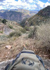
| no partners | | Having moved to Sahuarita and viewing the Santa Rita ridge line from the house I’d spent a few months thinking it would be cool to walk the whole N to S ridge line. I’d never been in the Santa Rita’s but I’m plenty ambitious when it comes to hikes. As I started poking around researching the feat, I found little info on the high points until I found Chumley and John10s triplogs for "The Rita Lode, AZ" from June 2025. I mentally arrived at adding some additional peaks, and possibly tequila, and with the shorter fall days splitting it across 2 days with an overnight on the ridge.
I roped Overthehills into the plan and set about figuring out the water logistics. While springs dot the map for the area, the reports for them were dry. With the plan now shifting to lugging 15+ lbs of water to overnight the ridge I figured I’d better do a scouting trip to find a suitable camp location. On 9-26 I loaded my pack with 4 liters of water, my overnight gear, a sturdy tripod, geared tripod head, and 2 camera lens plus my R10 with an 18-250mm lens. On the crop sensor R10 that lens is effectively a 29-400mm, my hiking lens. This equaled a 37 lb pack which if I swapped the tripod and extra lens for 3 more liters of water I’d be at the weight of my overnight Rita Lode pack. Being new to the Rita’s it couldn’t hurt to scout and train - 2 birds 1 scone.
9-27-25:
The 27th was the morning after a rather robust week of rain storms and headline flooding in central AZ, and the Rita’s were damp and covered in moody clouds. Great photography conditions. The weather was forecasted clear, but having watched storms form on the range for months I was 50/50 that’d be the case. The goal was to find a camp location around Mt Ian. As I trudged up old baldy trail with my bino harness, camera, and full pack I wasn’t yet at Josephine saddle when the sprinkling started. It quickly ceased but the weather now called for rain at 2pm. Plenty of time. When I crested Old Baldy saddle the skies eastward over Sonotia and southward were tauntingly gray. The wind was strong at the saddle but I still boiled water for a trail lunch. I carried it, might as well enjoy it.
While it was encouraging to pass a strongly gushing Bellow Spring on my ascent, it occurred to me that having the volume of metal on me that I did, while standing on the exposed highest point in the region as a storm approached was not gold star decision making. I stashed my pack and tripod in a bush, kept my bino harness on which is also my possibles pouch, and grabbed a liter of water before pushing up the crest trail toward Mt Ian looking for suitable camp locations for 2 tents. I ventured a ways findings spaces for 1 tent comfortably but borderline for 2. The sprinkles started again but more vigorously this time so I retreated in the direction of my pack which felt counter intuitive due to my aluminum tripod and metal tripod head. DIY lightening rod anyone?
As I reached my pack the clouds broke open but not enough to head up Wrightson. I instead used the opening to justify taking the longer Super Trail towards Josephine Peak and back down the mountain. Baldy Spring was dry, but there was an unmarked trickle about 300 yards past it down trail on the W slope of Wrightson where the trail contours across a drainage. From Josephine saddle I poked over the Agua Caliente trail to skirt Jack Mt and then head down the Carrie Nation trail. I crossed ample amounts of bear and cat scat…the cat clearly larger than a bobcat and within 2 days, and 1 of the bear piles being from that day. The CN trail was eerily quiet, not a bird or squirrel, no breeze now. So quiet that I would have taken a mosquito buzz. The spring half way down the CN trail was flowing and as it converged with 2 other springs it turned to a full blown creek that was strongly flowing for about a 1/2 mile I’d guess. Safely at the truck but having not used the tripod or extra lens I couldn’t help but laugh at myself for lugging the weight on the 3,587’ 12 mile trip up and down the mountain.
10-5-25:
Having struck out on campsite locations the prior weekend, I decided to take a second scouting trip, this time up the Four Spring trail and try to recreate Chumley and John10s path minus Josephine. I was also wanting to put eyes on Florida peak for a possible inclusion in my future Rita Lode trek. This time I left all the overnight stuff and my tripod at home but brought a 5th liter of water. The first 1.73 miles to Kent spring from Madeira TH got the blood pumping. Sylvester Spring box was strongly flowing but visually warranted a filter. The journey up the Four Springs trail was excellent. No clouds in the sky this day. I saw a young yearling buck and doe grazing in the pines near 8000’ which was the first of 5 deer I’d see on the day. No other mammals were encountered all day other than at the TH.
Once on the ridge I pushed N to McClearly, bush busting an overgrown trail following the hearty monsoons the past few months. After spooking/getting spooked by a rattler in some boulders on my way to McClearly I made the peak. While I never found the log jar for the peak I did manage to brush my boot against a cactus. Having striped to my bare foot to clean up the prickers I put on my gaiters and began looking at 88Mac. No amount of looking at it was changing the slope up it so I set off.
Ascending the northward facing shaded slope of 88Mac might be the most satisfyingly unsatisfying peak to climb in the range. No trail, just me and the 700’ of gain in under a 1/2 mile. I was picturing doing this climb with added lightweight overnight gear and 15 lbs of water in a few weeks and thinking that was another dumb idea. On the barren top with sweeping views, I found the log jars stashed under a small rock pile. I scouted Pine (Mt? Peak? Highpoint?) from the Mac and set off.
Having dilly dallied for a nice 45 min broth and sandwich break on my way up Four Springs in the sweet smelling Ponderosa’s, digging cactus out of my foot on McCleary, and zen breathing my way up Mac and Pine I didn’t reach the top of Pine until 3:10pm. I found the log and signed my name. No one had signed Mac or Pine since Chumley and John10s in June 2025. Although I did miss the log on McCleary, I think it’s fair to guess these peaks are seldom climbed by humans in recent years. Maybe a couple each year.
I looked across to Rice, did some quick math on my pace, remaining daylight, and also factoring in that I told my wife to expect me home around 5 (that wasn’t going to happen!). I yielded my hubris and decided that I was needing to skip Rice and Ian, and yet again wouldn’t be going up Wrightson. A glance at my map and I determined that after dropping down some I could hold elevation and slice across the E face of Rice until I bumped into the Crest trail. Hooking up with the trail 1/2 mile or so from Baldy saddle I boogied along, finally back on a trail. A quick break at Old Baldy for a photo shoot of a Cous doe and fawn, then off for the truck. On the descent I noticed Bellow was still flowing a week later but not quite as strongly. I completed the second 12 mile day with 4160’ of gain before last light and headed for Sahuarita, reasonably happy with my 2 scouting trips but also curious what I might have missed seeing on Rice and Ian. Having scouted the route it’s to be determined if I’ll be taking Overthehills on a Rita Lode attempt this fall or if we put it off til spring when the days are a bit longer. To not clog the server no routes attached, look at the triplogs I mentioned for them. |
  |
Bellows Spring |
Quart per minute |
Quart per minute |
| | | Conservative estimate of rate - flowing very strongly on 9-27-25 and still flowing a little lighter 10-5-25 |
|
Carrie Nation Spring |
Quart per minute |
Quart per minute |
| | | Spring is a trickle but quickly merged with 2 other springs down trail and became a creek |
|
Sylvester Spring |
Quart per minute |
Quart per minute |
| | | Spring box overflowing, filter recommended | | | |
|
|
|
 Route Editor


 . I made my firearm a little more accessible, and we continued to head uphill, towards the certain death the woman was certain we were facing. No bears were spotted, but there was definitely a well fed one recently in the area.


