username
X
password
register
for free!
help
ArticlesGuidesRoutes
 
Photosets
 
 Comments
triplogs   photosets   labels comments more
Smith Ravine Trail #297 - 18 members in 54 triplogs have rated this an average 3.4 ( 1 to 5 best )
1, 2, 3  Next
54 triplogs
login for filter options
Jun 08 2025
avatar

 Guides 2
 Routes 127
 Photos 1,478
 Triplogs 129

male
 Joined May 07 2019
 Tempe, AZ
Smith Ravine Loop, AZ 
Smith Ravine Loop, AZ
 
Hiking avatar Jun 08 2025
mikemcgTriplogs 129
Hiking6.31 Miles 1,799 AEG
Hiking6.31 Miles   3 Hrs   55 Mns   2.19 mph
1,799 ft AEG   1 Hour   2 Mns Break
 
1st trip
Partners none no partners
Route Scout Route Recorded  on Route Scout | Pop | Map | Popup | MapDEX
Nice, pleasant walk through the woods. Started at 1020. The parking lot only had room for 4 vehicles parallel parked plus mine parked perpendicular to all the others. Gradual uphill along a ridgeline on a very well-maintained dirt trail. Many, many birds. We were interrupted multiple times along the way by texts and calls from work that required us to stop and respond. Some nice views along the way. Nice overlook of the ravine near the top. We took the backside route down, on an unnamed trail along a different ridgeline that ran along the northern edge of the ravine. The unnamed trail actually ascended another 150 feet to reach a peak with excellent views before descending on a less-maintained but easily identified trail that was covered in loose rocks and loose dirt throughout the entire descent. The views of Spruce Mountain, Bigelow Peak, many other mountains, and the ravine were actually much better from this unnamed trail than they were from the official trail. We reached the Hoot Owl trail at the bottom and followed it back to the parking lot to complete the loop. Nice, pleasant route with no people except for 2 mountain bikers whom we encountered at the very beginning. The trail alternated between extensive shade and bright sun. There were 2 wild turkeys at the peak. Some cool purple rocks too. Beautiful day in the woods.
 Fauna
 Fauna [ checklist ]
[ checklist ]  Wild Turkey
 Named place
 Named place [ checklist ]
[ checklist ]  Smith Ravine  Spruce Mountain
  4 archives
Dec 28 2024
avatar

 Guides 2
 Routes 6
 Photos 105
 Triplogs 23

47 male
 Joined Dec 11 2003
 Phoenix, AZ
Smith Ravine Trail #297Prescott, AZ
Prescott, AZ
Hiking avatar Dec 28 2024
ChapmanTriplogs 23
Hiking6.92 Miles 1,504 AEG
Hiking6.92 Miles   2 Hrs   35 Mns   3.05 mph
1,504 ft AEG      19 Mns Break
 
1st trip
Linked   none no linked trail guides
Partners none no partners
Route Scout Route Recorded  on Route Scout | Pop | Map | Popup | MapDEX
Took a side trip from the end of the trail to the north summit. Enjoyed the Christmas decorated tree while we rested before our trip back down.
_____________________
 
Sep 30 2023
avatar

 Guides 12
 Routes 192
 Photos 863
 Triplogs 356

42 male
 Joined Nov 30 2015
 Phoenix, AZ
Saddles 50, AZ 
Saddles 50, AZ
 
Run/Jog avatar Sep 30 2023
ShatteredArmTriplogs 356
Run/Jog48.00 Miles 6,644 AEG
Run/Jog48.00 Miles   14 Hrs   24 Mns   3.50 mph
6,644 ft AEG      42 Mns Break
 no routesno photosets
1st trip
Was signed up for the 100. But due to an injury that prevented me from doing much on Labor Day weekend, I figured I'm probably in no condition to attempt that, so the primary goal was 50.

Started out early in Downtown Prescott, and basically followed 89 2.5 miles to the trail. Pleasant temps in the morning, nothing remarkable as I made my way up to Groom Creek trail 10 miles in. By then it was light out, and it was nice and cool for the climb up Spruce and down Smith Ravine.

On Homestead, it started warming up, and I realized I had basically no energy. I'll chalk that up to a quick turnaround from flying back across the country on Thursday evening... Didn't want to be struggling just 20 miles in, but you can't have it all. At least the breeze tempered the sun a little.

Ranch trail was where the misery really started. I expected the climb, having been on that trail a couple times, but I absolutely hated Badger Mountain Trail. Long, windy, exposed, with the type of switchbacks that were probably designed to ensure mountain bikers don't have to put in any effort at all. 11 miles to do what's probably a 3-4 mile drive... Hopefully I never have to see Badger Mountain Trail ever again.

Things improved a little on Sundog Trail, which I actually liked better than BM. Then Peavine, which is just...flat. By the time I got to the dells, it was 5pm, and I figured the sun would be down before I got to 50. The north side of Watson Lake was actually a lot of fun, and I liked trying to move through there as fast as possible. Probably the only part of the day that was legitimately enjoyable.

One of my friends was waiting for me at the Watson Boat Ramp with a beer, which was a nice surprise.

By the time I got to Willow, it was getting dark, and I had to use a light most of the way through there. There were also thunderstorms moving in, which was fun (they didn't get to Willow, but I heard it got a little crazy closer to Granite Mountain). I really don't recommend going through the dells in the dark, it definitely upped the difficulty a level or two.

After that section, I decided to make it official and not go for what would've probably been a last place finish. I'm starting to come around to one of my friends' views that 50 miles is a superior distance to 100.
_____________________
 
Aug 24 2023
avatar

 Guides 264
 Routes 2,797
 Photos 14,494
 Triplogs 5,894

55 male
 Joined Nov 20 1996
 
Prescott Lakes Tour, AZ 
Prescott Lakes Tour, AZ
 
Hiking avatar Aug 24 2023
joebartelsTriplogs 5,894
Hiking19.71 Miles 2,941 AEG
Hiking19.71 Miles   8 Hrs   26 Mns   2.59 mph
2,941 ft AEG      49 Mns Break
 
Route Scout Route Recorded  on Route Scout | Pop | Map | Popup | MapDEX
I hooked up with the fine line between hobbyist and mental illness for one of my favorite Preskit loops.

Seven Mile Gulch Trail #9854
This is a fabulously steep motorcycle trail that oughta scare away rose garden thieves.

The tread seemed less rutted with fewer ankle-buster rocks. I suggested a tractor with a grading blade had passed over since our last visit. Bruce kicked me in the groin and called me a few names, so I picked up the pace and made his sweat sweat. The breezeless humid atmosphere had sweat trickling off my elbows.

We hiked up 2.3mi to #62. The balance 0.8mi of this trail gains a lousy 142ft to #299. We get to the same spot in 5.3mi looping down through la la land.

Ranch Trail #62
The original 2.75mi NE segment is primarily chaparral. Our loop includes the view-rific western 4.2mi created around 2013 for the PCT(Circle Trail). There are a few stellar views out of the mountains looking through therapeutic pines.

Upon reaching the Senator Hwy, we mutually agreed to omit the 2-mi out-n-back to Goldwater Lake. Bruce is pushing 70 so I pretended to be tired.

Watershed Trail #299
This is the second of the two big ascents on our loop. It has more ankle-buster rocks and a few ruts. While it wasn't as bad in that regard as I recall, it still packs a good punch of undesirable. After ascending 1.75mi/600ft you think it's over. The balance 1.75-mi is a mental and physical rollercoaster.

That said, there are good stretches through the pines, and the payoff is #297. We utilize Spruce Mountain Road through a mtn community of cabins, passing an ore cart from Midnight Test Mine en route to #297.

Smith Ravine Trail #297
This trail has changing views through steep grades. Springs are passed along the way through a large stretch of pines. There is little not to like considering we descend it and reap the rewards.

Homestead Trail #305
Like the AZT, this trail zigzags all over the place in support of gentle backpacking. It's a nice trail with pines galore, just drags on with anticipation of the grand finale.

Lynx Recreation Trail #311 - Lake Loop
It's paved, stay away. I love it.

Synopsis
This loop will offer little joy for those seeking moderate. Albeit a breezeless sweat-fest on this day, it's a great loop with varied terrain and views for the untimid. Need more twenty-mile hikes, this one always delivers. Bruce has been babysitting a 2-year-old so I did my best to keep him sharp as a tack.
_____________________
- joe
 
Aug 24 2023
avatar

 Guides 41
 Routes 1,626
 Photos 14,983
 Triplogs 2,760

69 male
 Joined Jan 20 2009
 Far NE Phoenix,
Prescott Lake Tour, AZ 
Prescott Lake Tour, AZ
 
Hiking avatar Aug 24 2023
The_EagleTriplogs 2,760
Hiking20.33 Miles 2,949 AEG
Hiking20.33 Miles   8 Hrs   25 Mns   2.68 mph
2,949 ft AEG      49 Mns Break14 LBS Pack
 
Route Scout Route Recorded  on Route Scout | Pop | Map | Popup | MapDEX
We've done this one numerous times, typically in August. At the multi-use trailhead, there were a handful of motorcycles getting ready to start their day. We would be passed by 3 of them climbing the Seven Mile Gulch Trail and that would be it for the day. That climb is always a sweat fest in August. I told Joe it was so bad this time, my sweat was sweating.

On the Ranch Trail, things are much nicer. It trends downhill and is much more picturesque among the tall pines. At the bottom, we made the decision to forgo the extra 2 miles round trip to visit Goldwater Lake and headed up the Watershed Trail. The dark clouds were building, but we only briefly got sprinkled on.

The highlight of this loop for me is the Smith Ravine Trail. Tall pines with a view.

The Homestead Trail roller-coasters over to the Lynx Lake, where we picked up the Lynx Recreation Trail (paved), and where we saw our only "Hikers" on the day.

Temps were in the 70s to low 80s all day, with a lot of cloud cover. It would have been nice to have a bit more of a breeze. The JBM pegged a few times but mainly held at 7.0 for most of the day.

water 1 out of 5water 2 out of 5water 3 out of 5water 4 out of 5 Lynx Lake 76-100% full 76-100% full

water 1 out of 5water less than maxwater less than maxwater less than max Smith Ravine Spring Dripping Dripping
_____________________
There is a very fine line between "hobby" and "mental illness."
Dave Barry 🦅
 
Sep 25 2022
avatar

 Guides 107
 Routes 249
 Photos 2,067
 Triplogs 514

male
 Joined Nov 18 2005
 Phoenix, AZ
Smith Ravine Trail #297Prescott, AZ
Prescott, AZ
Hiking avatar Sep 25 2022
nonotTriplogs 514
Hiking26.80 Miles 3,000 AEG
Hiking26.80 Miles
3,000 ft AEG
 no routesno photosets
1st trip
Enjoyed an extended weekend in Prescott National Forest.

All the trails were in good condition. I spent time fixing drainage issues on Smith Ravine Trail. Highlight of the trip was eating lunch on Spruce Mountain while deer were grazing 50 feet away.

Lots of friendly people out and about on the Lynx Lake Loop. The southern portion of the Homestead trail would make for a good backpacking trip right about now. Found a new trail to add to HAZ during my wanderings.
wildflower observationwildflower observationwildflower observationwildflower observationwildflower observation
Wildflowers Observation Substantial

water 1 out of 5water 2 out of 5water 3 out of 5water 4 out of 5 Lynx Lake 76-100% full 76-100% full
100% full and a healthy flow over the spillway

dry Smith Ravine Spring Dry Dry
appeared dry though there was water in about every other drainage
_____________________
http://hikearizona.com/garmin_maps.php

Hike Arizona it is full of sharp, pointy, ankle-twisting, HAZmaster crushing ROCKS!!
Hike Arizona it is full of sharp, pointy, shin-stabbing, skin-shredding plants!
Hike Arizona it is full of striking, biting, stabbing, venomous wildlife!
 
Sep 10 2022
avatar

 Guides 1
 Routes 5
 Photos 656
 Triplogs 512

47 male
 Joined Jul 20 2007
 Gilbert, AZ
Smith Ravine Trail #297Prescott, AZ
Prescott, AZ
Hiking avatar Sep 10 2022
jtaylorTriplogs 512
Hiking6.40 Miles 1,176 AEG
Hiking6.40 Miles
1,176 ft AEG
 no routes
1st trip
Linked   none no linked trail guides
Partners none no partners
Whereas my last trail was exposed and overgrown, this was shady and well-maintained. First time on this trail and it’s easily in my top 10 in AZ. Weather and crowds cooperated for a perfect day with the pup. Especially enjoyed the view looking North from Smith Ravine.
_____________________
“...wilderness is not a luxury but a necessity of the human spirit, and as vital to our lives as water and good bread.”
-Edward Abbey, Desert Solitaire
 
Aug 21 2022
avatar

 Guides 2
 Routes 207
 Photos 93
 Triplogs 204

male
 Joined Aug 08 2020
 Phx az
Hoot Owl Trail #745Prescott, AZ
Prescott, AZ
Hiking avatar Aug 21 2022
ScaredyCatTriplogs 204
Hiking17.06 Miles 2,416 AEG
Hiking17.06 Miles   6 Hrs   51 Mns   2.53 mph
2,416 ft AEG      7 Mns Break
 no routesno photosets
1st trip
Linked   linked  
Partners none no partners
On hoot owl I saw no humans but one animal sighting. Looked like a turkey but with more colorful rear feathers? Smith ravine saw 1 person + a single deer. Showed 1k aeg after 1 way on hoot owl. Able to push myself stronger on this solo outing.
 
Aug 14 2022
avatar

 Guides 12
 Routes 192
 Photos 863
 Triplogs 356

42 male
 Joined Nov 30 2015
 Phoenix, AZ
North Spruce loop, AZ 
North Spruce loop, AZ
 
Run/Jog avatar Aug 14 2022
ShatteredArmTriplogs 356
Run/Jog18.95 Miles 2,495 AEG
Run/Jog18.95 Miles   5 Hrs   6 Mns   3.75 mph
2,495 ft AEG      3 Mns Break
 
no photosets
1st trip
Partners none no partners
One of those "just have to get the miles" days. Thought of a decent loop option in Prescott, and got started at around 7:30am. Had to poop pretty bad, but the portajohn was occupied by someone who sounded like he was having quite the struggle, and it didn't sound like it was close to being resolved, so I decided to hold it in. I feel like the person struggling to hold it in has a more urgent need of a toilet than the person who can't figure out how to force it out, but I don't make the rules.

Took quite awhile before things loosened up enough to make running feel safe. The climb up Ranch Trail is very, very gradual. Nothing steep until I left the PCT and got onto the moto trail that heads towards Spruce Mtn.

Was hoping my early start would avoid any motorcycle traffic, and it did. Only saw a single pair of hikers on that stretch. When I hit the FR, storms were starting to roll in and there was thunder, which was a little surprising considering it was only 10am at this point. So I made quick work of getting to Smith Ravine and getting off the mountain. Thunder was getting closer and more frequent, so I decided to take a side trail that drops down to a road at the bottom of the ravine. Turns out this was private property, but it was only posted on the opposite edge of the property. Maybe I'm lucky I didn't get shot.

Homestead trail was nice enough, or it would be if I weren't hurting at this point. It was a slow slog back to the car that never seemed to end. A little rain here and there, and the thunder didn't stop, but I avoided serious weather until the drive back down the hill.
_____________________
 
May 07 2022
avatar

 Guides 3
 Routes 161
 Photos 477
 Triplogs 147

70 male
 Joined Jan 02 2016
 Prescott, AZ
Smith Ravine Trail #297Prescott, AZ
Prescott, AZ
Hiking avatar May 07 2022
WhifferTriplogs 147
Hiking6.16 Miles 1,384 AEG
Hiking6.16 Miles   2 Hrs   37 Mns   2.38 mph
1,384 ft AEG      2 Mns Break
 
1st trip
Linked   none no linked trail guides
Partners none no partners
Route Scout Route Recorded  on Route Scout | Pop | Map | Popup | MapDEX
Trailhead is 5 miles from the intersection of Walker Road and AZ 69, a couple feet past the 5 mile marker, so you don't need to use a driving app to find the parking area, even though there is no sign on the road and the entrance is easy to miss unless you are driving well under the speed limit. The first 1.5 miles are all a steady climb and most of the rest is uphill also, although the trail crosses a few ravines, so there are a some downhill sections on the way out from the trailhead. The recorded hike is out and back. Hoot Owl Trail shares the trailhead, but no other trails were seen. Mostly Ponderosa pines and more Gambel oaks than I've seen on any other trail around Prescott, along with a few alligator junipers. Many Manzanita, but hardly any desert holly bushes which is the opposite of the area north of Granite Mountain and est of Williamson Valley Road. About a mile from the trailhead is a jumble of purple rocks that my wife said are probably amethyst.
wildflower observationwildflower observationwildflower observationwildflower observationwildflower observation
Wildflowers Observation Light
In early May, lots of flowering Manzanita; many small yellow flowers; a few purple flowers; and a single flowering strawberry hedgehog cactus
_____________________
  1 archive
Dec 27 2021
avatar

 Guides 170
 Routes 148
 Photos 5,914
 Triplogs 2,097

48 male
 Joined Apr 12 2004
 Tucson, AZ
Spruce Mountain Road, AZ 
Spruce Mountain Road, AZ
 
Hiking avatar Dec 27 2021
PrestonSandsTriplogs 2,097
Hiking3.10 Miles 815 AEG
Hiking3.10 Miles
815 ft AEG
 no routesno photosets
1st trip
Partners none no partners
Shauna and I started our evening hike near the Midnight Test Mine on Spruce Mountain Road in freezing temps and gusty winds. A few inches of snow lay on the north slopes and the road as we climbed higher. Spruce Mountain summit gave us an awesome view to the west of low, boiling storm clouds rolling over the Sierra Prieta crest. Checked out a bit of the upper Groom Creek Loop before starting back down. Brilliant pink sunset light on storm clouds during the descent: very cool. I hadn’t done this hike since I lived in Prescott, so it was nice to get to do this one again.
_____________________
"…you never know when a hike might break out" -Jim Gaffigan
 
Oct 18 2021
avatar

 Guides 13
 Routes 38
 Photos 1,651
 Triplogs 577

60 male
 Joined Nov 15 2005
 Jackson, CA
Smith Ravine Trail #297Prescott, AZ
Prescott, AZ
Mtn Biking avatar Oct 18 2021
toddakTriplogs 577
Mtn Biking
Mtn Biking
 no routesno photosets
1st trip
Linked   linked  
Partners partners
t282828
Quality mtn bike ride (downhill direction of course)
_____________________
  1 archive
Oct 08 2021
avatar

 Guides 13
 Routes 38
 Photos 1,651
 Triplogs 577

60 male
 Joined Nov 15 2005
 Jackson, CA
Seven Mile Gulch Trail #9854Prescott, AZ
Prescott, AZ
Hiking avatar Oct 08 2021
toddakTriplogs 577
Hiking23.00 Miles 3,500 AEG
Hiking23.00 Miles   9 Hrs      2.56 mph
3,500 ft AEG
 no routesno photosets
1st trip
Yet another @The_Eagle / @joebartels quality mashup route they did a couple weeks ago, linking primo singletracks with tolerable two-tracks.
_____________________
 
Sep 25 2021
avatar

 Guides 41
 Routes 1,626
 Photos 14,983
 Triplogs 2,760

69 male
 Joined Jan 20 2009
 Far NE Phoenix,
Prescott Lakes Loop, AZ 
Prescott Lakes Loop, AZ
 
Hiking avatar Sep 25 2021
The_EagleTriplogs 2,760
Hiking25.24 Miles 3,475 AEG
Hiking25.24 Miles   9 Hrs   35 Mns   2.85 mph
3,475 ft AEG      43 Mns Break14 LBS Pack
 
Route Scout Route Recorded  on Route Scout | Pop | Map | Popup | MapDEX
We've done variations of this loop multiple times and it'll be done again.

Seven Mile Gulch Trail is my least favorite. When it's warm or sunny, it's a sweat feast. On this day it was in the 50's and cloudy, but still sweaty. We took a wrong turn and thought it might work out until we decided to back track. This is a multi-use trail that we've never seen anyone on.

Ranch Trail is a jem. Pleasant grades, good views and smooth trails. You will almost always run into hikers or MTB'rs.

We expected to see people on the Goldwater Lakes Trail. Families enjoying the day, hikers, bikers and kayakers. The sprinkles stared for the day.

Watershed Trail is another multi-use trail. We saw noone on the entire length of this trail. The upper east TH has been rerouted since last year. We had a quick 11 minute lunch in high winds, rain and what felt like 45 degree temps, each huddled under our umbrellas. We had to get moving to get some warmth back.

We took our road walk up Spruch Mountain Rd to get on the Smith Ravine Trail. This is another favorite. Tall pines, shade and nice trail tread. The sun finally made an appearance so we finished our lunch break here.

Homestead Trail is a pleasant gentle roller coaster making your way over to Lynx Lake.

The expected dog walkers were abundant on the Lxnx Recreation Trail. Good views of the now calm lake.

We hit part of the Salida Gulch Long Loop and the Highlands Trail to finish things off. Other than the lunchtime squall, perfect weather.

No @Hansenaz was spotted in the Lynx Lake/Creek area
 Named place
 Named place [ checklist ]
[ checklist ]  Lynx Lake
wildflower observationwildflower observationwildflower observationwildflower observationwildflower observation
Wildflowers Observation Moderate

water 1 out of 5water less than maxwater less than maxwater less than max Deer Lick Spring Dripping Dripping
water report recorded in the field on our app Route Scout

water 1 out of 5water 2 out of 5water 3 out of 5water 4 out of 5 Lynx Lake 76-100% full 76-100% full

dry Sevenmile Tank Dry Dry
water report recorded in the field on our app Route Scout

water 1 out of 5water 2 out of 5water 3 out of 5water 4 out of 5 Upper Goldwater Lake 76-100% full 76-100% full
_____________________
There is a very fine line between "hobby" and "mental illness."
Dave Barry 🦅
 
Sep 25 2021
avatar

 Guides 264
 Routes 2,797
 Photos 14,494
 Triplogs 5,894

55 male
 Joined Nov 20 1996
 
Prescott Lakes Tour, AZ 
Prescott Lakes Tour, AZ
 
Hiking avatar Sep 25 2021
joebartelsTriplogs 5,894
Hiking24.15 Miles 3,564 AEG
Hiking24.15 Miles   9 Hrs   33 Mns   2.74 mph
3,564 ft AEG      45 Mns Break
 
Route Scout Route Recorded  on Route Scout | Pop | Map | Popup | MapDEX
Seven Mile Gulch Trail #9854
Starting temps put the last 6 months to shame. About 3 minutes up we passed new signage for Hoot Owl #745. Minutes later, babbling up a storm we missed a turn. Bruce wanted to check it out and who am I to argue when he wants to add mileage to the 21.4-mile plan. 1.4 miles later we were sensibly back to the missed turn. We've hiked a variation of this loop several times. Albeit humid we both agreed it was nice not to be baking for once. Crane flies swarmed us for the ascent. Per usual, the dizzy drunken flies just bump without harm.

Ranch Trail #62
2.25-mi up #9854 we turned onto #62 for its upper 4-mile stretch. Lots of tall pines in the first 2-miles heading west. This wraps around the northern end of the Bradshaw range with views over Prescott and ends dropping down to the Watershed TH along the Senator Highway.

Goldwater Lakes Trail #396
After crossing the Hwy it was 1.25 miles down to the lake. You can reach the lake 0.3 miles quicker but we opted for a shorter return after following the southern shore Banning Creek Trail. With summer out of the books and overcast, it wasn't very busy. Looks like they've been busy adding benches galore.

Watershed Trail #299
Back up to the Watershed TH, we took #299 up to the ridge in search of a lunch spot. Nearly a month ago, Bruce clued me in on the Klymit V-Seat inflatable seat cushion deal. They are super butt comfy! A storm drifted in, so we ate quickly and boogied onward. We got lucky, the storm didn't linger.

Spruce Mountain Road
This bridges the loop through an occupied belt of cabins with no trespassing signage galore and a few lonely fenced-in dogs seeking attention/blood. The Midnight Mine ore cart is the anticipated highlight.

Smith Ravine Trail #297
The death star busted through like a champ on our descent. We enjoyed a break that lasted longer than lunch heading down. Naturally, Bruce one-upped me with a larger seat cushion. An inflatable recliner by Christmas wouldn't surprise me.

Homestead Trail #305
This parallels Walker Rd to Lynx Lake. We shared the trail with a chic out walking her dogs.

Lynx Recreation Trail #311 - Lake Loop
Many HAZr's would probably avoid this, but I'm a big fan of this trail. It's always busy. Like the other little Prescott lakes, it's almost always a family atmosphere. With 24-mi within reach, Bruce found a way to make it happen.

Synopsis
When Bruce first put this loop out years ago I cringed my nose. It's turned into one of my favorites. Well over a third, possibly half is through or along tall pines. The icing on the cake today was my first 24 miler since @LindaAnn & @Tortoise_Hiker's 30-miler on Baldy! 5k / 24mi used to be my acceptance to worthy... lol
foliage observationfoliage observationfoliage observationfoliage observationfoliage observation
Autumn Foliage Observation Isolated
hints, yeah baby!
wildflower observationwildflower observationwildflower observationwildflower observationwildflower observation
Wildflowers Observation Light
nothing to write home about but a large enough stretch of insignificant yellows to not be forgotten
_____________________
- joe
 
Sep 04 2021
avatar

 Routes 80
 Photos 149
 Triplogs 78

male
 Joined May 23 2016
 Tempe, AZ
Smith Ravine Trail #297Prescott, AZ
Prescott, AZ
Hiking avatar Sep 04 2021
chrisbjohnsonTriplogs 78
Hiking6.10 Miles 1,376 AEG
Hiking6.10 Miles   2 Hrs   12 Mns   2.79 mph
1,376 ft AEG      1 Min Break
 no routesno photosets
1st trip
Linked   none no linked trail guides
Partners none no partners
_____________________
 
May 12 2020
avatar

 Routes 70
 Photos 3,081
 Triplogs 601

70 male
 Joined Feb 10 2019
 Cave Creek, AZ
Smith Ravine Trail #297Prescott, AZ
Prescott, AZ
Hiking avatar May 12 2020
LosDosSloFolksTriplogs 601
Hiking6.60 Miles 1,434 AEG
Hiking6.60 Miles
1,434 ft AEG7 LBS Pack
 no routes
1st trip
Linked   none no linked trail guides
Partners none no partners
We needed a hike and we needed it not to be in the valley of the oven. There are several on our list in the rim country but we tend to put those off because living in Cave Creek we have to go so far south in order to go north. Seems every time I opened HAZ over the last couple of weeks a lot of folks were hitting the Bradshaws. One hike that kept popping up in the triplogs was Smith Ravine Trail #297 so we decided to give it a go.

We have a dear friend named Bob that lives in Prescott and we invited him to join us. He agreed and met him at the trailhead for a 7am start. The trail starts at 6000' and goes up immediately. Like a tough golf course, it greets you with a firm handshake on the first hole. After less than 1/8th of a mile I was already short of breath and Bob reminded us that they have only 0-1 up there and not the 0-2 that we were accustomed to. :lol: Cathy and I eventually settled into a rhythm that would allow us to continue. We need to do more hiking at higher elevations it seems.

About the trail, it's great. Very reminiscent to us of a longer version of Brown's Trail #133 in the Four Peaks Wilderness, but without the views of Roosevelt Lake... Stunning vistas none the less. The standouts today were the blooming Manzanita's which were everywhere the Ponderosa Pines and the Oaks weren't. We only saw a few hikers all day, along with one sidelined mountain biker who appeared to need oxygen even more than me!
 Named place
 Named place [ checklist ]
[ checklist ]  Smith Ravine Spring
wildflower observationwildflower observationwildflower observationwildflower observationwildflower observation
Wildflowers Observation Isolated
Smattering of Lupine, lots of Manzanita in full bloom.

water 1 out of 5water 2 out of 5water less than maxwater less than max Smith Ravine Spring Quart per minute Quart per minute
_____________________
"If you wait, all that happens is you get older"
 
May 08 2020
avatar

 Guides 1
 Routes 447
 Photos 4,407
 Triplogs 938

68 male
 Joined Mar 09 2012
 Gilbert, AZ
Smith Ravine Trail #297Prescott, AZ
Prescott, AZ
Hiking avatar May 08 2020
rayhustonTriplogs 938
Hiking6.43 Miles 1,388 AEG
Hiking6.43 Miles   2 Hrs   51 Mns   2.40 mph
1,388 ft AEG      10 Mns Break
 
1st trip
Linked   none no linked trail guides
Partners none no partners
Route Scout Route Recorded  on Route Scout | Pop | Map | Popup | MapDEX
Day trip to Prescott Valley to visit an old Marine Corps buddy from back in the day. I decided to get a hike in beforehand.

Great trail. A burn area at the bottom leaves you exposed to the sun for half a mile but you’re in the shade most of the rest of the way.

When I reached the top of the ravine, I angled right to pick up a motorcycle trail then followed that to the top of a hill for some views.

Beautiful trail. Nice out but a tad hazy. Saw two people at the start and a couple more at the finish.
wildflower observationwildflower observationwildflower observationwildflower observationwildflower observation
Wildflowers Observation None
A single patch of lupine was all I saw.
_____________________
 
May 06 2020
avatar

 Guides 73
 Routes 176
 Photos 10,174
 Triplogs 2,324

46 male
 Joined Sep 08 2006
 
Smith Ravine Trail #297Prescott, AZ
Prescott, AZ
Hiking avatar May 06 2020
JimTriplogs 2,324
Hiking8.60 Miles 2,000 AEG
Hiking8.60 Miles   3 Hrs   30 Mns   2.65 mph
2,000 ft AEG      15 Mns Break10 LBS Pack
 no routes
1st trip
Linked   none no linked trail guides
Partners none no partners
I journeyed to the land before Scott, because basically everything up here is new to me and I haven't even been near Pre-Scott in nearly a decade. September of 2010, and back then I was over near Granite Mountain on a climbing route. Well, I needed to change that, so I did. I still feel the same about the stop and go on SR 69, 10 years later.

I came for Spruce Mountain, not this trail itself. I saw this before the Groom Crick route, but read elsewhere that is a busy route. #297 was not. I saw a number of hikers and bikers on the summit from Groom. The road walk was fine, and the views were enjoyable. The Bradshaw Mountains are nice, just very ranchetted up. Shocking amounts of development here. But, if I had money to burn, I'd buy a disposable house in a tinder box, too! I bet those premiums are worth every subsidized dollar! Still, I wouldn't want to live in a place like Potato Patch in a snowy winter. Seasonally? Hmmmmm.

The trail is in what I now consider excellent condition, for Arizona with our ever present rock, shallow soils, and propensity towards soil eroding summer thunderstorms(and now warm, tropical-moisture-infused winter storms). The lower burn as mentioned by Preston is open, but the brush is returning to full flammability! Nah, it actually looks Okay, and there are some pine seedlings out in it. Mostly, it looks like a random fuel reduction project was carried out here. The rest is half decent pine. There was even a small stream flowing, which was nice.

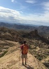
Spruce Mountain was interesting. Scenic, cool, had a good view of all new terrain. After Union, I felt it offered a more interesting and diverse view than Union, though Union has a better view of the Tower (Massif?) to the south, and on a clear day would provide some excellent views to perhaps as far as the Eagle Tails and Woolsey. Spruce offers up north views of dead volcanoes, plus some filler in Sedona.

Probably the most interesting thing was the view to the West-northwest out over SR 89, Granite Mountain, and Prescott, as that is more undiscovered country, for me. Aquarius Mountains, Santa Maria Mountains, and all. Do I sense a dawning of a new age?

water 1 out of 5water 2 out of 5water 3 out of 5water 4 out of 5 Smith Ravine Spring Gallon + per minute Gallon + per minute
Presumably the flowing stream.
_____________________
🍭
 
May 02 2020
avatar

 Guides 12
 Routes 192
 Photos 863
 Triplogs 356

42 male
 Joined Nov 30 2015
 Phoenix, AZ
Groom Creek Loop via Smith Ravine, AZ 
Groom Creek Loop via Smith Ravine, AZ
 
Run/Jog avatar May 02 2020
ShatteredArmTriplogs 356
Run/Jog18.00 Miles 3,470 AEG
Run/Jog18.00 Miles   4 Hrs   47 Mns   3.76 mph
3,470 ft AEG
 
no photosets
1st trip
Partners none no partners
A few friends were gonna go for a run starting at Smith Ravine TH, so I thought it would be fun to revisit the Groom Creek Loop (so named because it is bisected by Wolf Creek). Right off the bat, I noticed that either they were much faster than the last time I ran with them, or I was much slower, or a combination of both, so "with" really just means "started at the same time."

Good weather, and Smith Ravine Trail is nice. Not too steep and lots of shade. Spruce Mountain Road is meh.

Stopped at the lookout for a few minutes, then headed down Groom Creek Loop in the CW direction. Forgot how nice Spruce Ridge is. Definitely one of the most serene trails in the Prescott area; it feels like you're really up in the mountains. Getting back up to Spruce Mountain was a bit of a grind.

Back at the Smith Ravine junction, I ran into a mountain biker I recognized from 4-5 years ago. Cool. The few miles back down were a little painful, had some aches, pretty winded, chafing, etc. Was glad to be done.

Very worthwhile route; would do again.

water 1 out of 5water 2 out of 5water less than maxwater less than max Smith Ravine Spring Quart per minute Quart per minute
Water in the creek at the trail crossing.
_____________________
 
average hiking speed 2.58 mph
1, 2, 3  Next

WARNING! Hiking and outdoor related sports can be dangerous. Be responsible and prepare for the trip. Study the area you are entering and plan accordingly. Dress for the current and unexpected weather changes. Take plenty of water. Never go alone. Make an itinerary with your plan(s), route(s), destination(s) and expected return time. Give your itinerary to trusted family and/or friends.

helpcommentissue

end of page marker