username
X
password
register
for free!
help
ArticlesGuidesRoutes
 
Photosets
 
 Comments
triplogs   photosets   labels comments more
Chiricahua Shuttle - 50 members in 106 triplogs have rated this an average 4.8 ( 1 to 5 best )
1, 2, 3, 4, 5, 6  Next
106 triplogs
login for filter options
Mar 28 2023
avatar

 Guides 4
 Photos 4,732
 Triplogs 2,607

55 male
 Joined Sep 29 2004
 Small Town USA
Chiricahua ShuttleTucson, AZ
Tucson, AZ
Hiking avatar Mar 28 2023
SkyIslander18Triplogs 2,607
Hiking11.00 Miles 500 AEG
Hiking11.00 Miles
500 ft AEG
 no routes
The shuttle service is back up and running, the trails are now free of ice and the rock slides have been cleaned up ... time for a hoodoo hike!
Shuttle picked us up at Faraway Ranch, picked up 8 more at the campground and drove us all up to Massai Point for the hike back down to Faraway Ranch.
Sunny clear blue skies with a slight breeze all the way down.
Such an amazing place throughout with Inspiration Point & Heart of Rocks the 2 big highlights.
Wildlife spotted - 10 white tail deer, 20 turkey, 1 coati, several hawks and Mexican jays.
Solid hike, solid partner.
I sure hope this place does NOT get National Park status ... I like it just the way it is!
:D
_____________________
https://www.instagram.com/skyislander22/
 
Apr 25 2022
avatar

 Guides 4
 Photos 542
 Triplogs 573

46 male
 Joined Oct 19 2010
 Mesa, AZ
Chiricahua ShuttleTucson, AZ
Tucson, AZ
Hiking avatar Apr 25 2022
Charger55Triplogs 573
Hiking9.00 Miles 2,778 AEG
Hiking9.00 Miles
2,778 ft AEG
 no routesno photosets
1st trip
The Chiricahua Shuttle isn't actually operating...but the Happy Wife Express offered luxury class service from Bonita Canyon Campground to Echo Canyon TH. I did the side trails to Inspiration Point and through the Heart of Rocks, both definitely worth it, and was back at the CG in time for lunch.
_____________________
"I've driven across deserts, driven by the irony, that only being shackled to the road could ever I be free"
- Frank Turner "The Road"
  1 archive
Oct 08 2020
avatar

 Guides 2
 Routes 25
 Photos 1,890
 Triplogs 604

41 male
 Joined Sep 13 2009
 Mesa, AZ
Chiricahua ShuttleTucson, AZ
Tucson, AZ
Hiking avatar Oct 08 2020
jochalTriplogs 604
Hiking8.00 Miles 1,100 AEG
Hiking8.00 Miles
1,100 ft AEG
 no routesno photosets
The shuttle was still closed for covid, but we put together our own shuttle by leaving a car at our campsite and starting at Massai Point.

Barely saw anyone the whole hike, just two sets of couples and a group of NPS trail workers who had just completed a project on the Sarah Deming trail.
_____________________
 
Apr 09 2020
avatar

 Guides 13
 Routes 38
 Photos 1,651
 Triplogs 577

60 male
 Joined Nov 15 2005
 Jackson, CA
Big Loop - Chiricahua National MonumentTucson, AZ
Tucson, AZ
Hiking avatar Apr 09 2020
toddakTriplogs 577
Hiking12.50 Miles 3,000 AEG
Hiking12.50 Miles   5 Hrs   30 Mns   2.27 mph
3,000 ft AEG
 no routes
1st trip
Drove over from the east side on FR 42 to the nearly deserted national monument. Clockwise around the loop with side hikes to Inspiration and Heart of Rocks. Fantastic!

On the way out the ranger was closing the gate at the entrance station - cars were no longer allowed in, but road walking or biking in is still allowed (2 miles to the visitor center).
_____________________
 
Apr 07 2018
avatar

 Guides 2
 Routes 25
 Photos 1,890
 Triplogs 604

41 male
 Joined Sep 13 2009
 Mesa, AZ
Chiricahua ShuttleTucson, AZ
Tucson, AZ
Hiking avatar Apr 07 2018
jochalTriplogs 604
Hiking8.00 Miles 1,100 AEG
Hiking8.00 Miles
1,100 ft AEG
 no routesno photosets
_____________________
 
Aug 18 2017
avatar

 Guides 1
 Routes 136
 Photos 22,415
 Triplogs 1,041

77 male
 Joined Feb 28 2003
 Tucson, AZ
Chiricahua ShuttleTucson, AZ
Tucson, AZ
Scenic Drive avatar Aug 18 2017
rwstormTriplogs 1,041
Scenic Drive
Scenic Drive
 no routes
1st trip
Linked   none no linked trail guides
Partners none no partners
The goal was to to camp two nights in the Chiricahua Mountains. Usually I head over to West Turkey Creek Canyon, but I want to save that for another trip. So, I started my search by stopping at the monument first. There weren't many spots taken, which surprised me, but soon I realized why. Because of past flooding problems there, the majority of sites were closed. This is like closed for the season, not based on any current flooding. A CYA move all the way. Only a few remained and there was occupancy, so I scratched the monument for camping. Next up it was over the mountain on FR 42. There are some decent dispersed sites along Pinery Canyon Road, but I really wanted to be in a spot with some open sky and hiking trails. I figured I would try Rustler Park next.
_____________________
 
Jun 09 2017
avatar

 Photos 792
 Triplogs 48

64 male
 Joined Nov 29 2009
 Gilbert, AZ
Chiricahua ShuttleTucson, AZ
Tucson, AZ
Hiking avatar Jun 09 2017
JohnnieTriplogs 48
Hiking
Hiking
 no routes
1st trip
Linked   none no linked trail guides
Partners partners
Danielle
glutz
Spent 2 1/2 days in the Monument and hiked to Inspiration point for the views from there, also covered the natural bridge trail to the ......yea you guessed it a natural bridge. Nice hike , probably overlooked by many. like many places in the park there was many signs from the last fire in the park but vegetation is definitely on the mend. also went up the Massai point one night for some star gazing and some views of the fires burning over in the Dragoon mountains. We hiked down thru Echo canyon and lower Rhyoalite down to the visitor center. We saved going to Heart of Rocks trail until a return visit this fall. We made a new friend "Danielle" who was originally from France. but now a residence of Tucson. She had a tremendous appreciation for the park and for life in general. A very good soul.One noteworthy sighting was a Montazumas Quail sometimes known as the Harlequin Quail, a first for me. I hope I took a picture or two that everyone might enjoy. This was my second trip to the Monument and most definitely not my last
 Named place
 Named place [ checklist ]
[ checklist ]  Chiricahua National Monument
 Meteorology
 Meteorology [ checklist ]
[ checklist ]  Fire - Wildfire  Moon
wildflower observationwildflower observationwildflower observationwildflower observationwildflower observation
Wildflowers Observation Light
_____________________
 
Apr 02 2016
avatar

 Guides 1
 Routes 148
 Photos 9,924
 Triplogs 3,652

63 male
 Joined Apr 02 2005
 Mesa, AZ
Chiricahua NM Loop with Sugarloaf, AZ 
Chiricahua NM Loop with Sugarloaf, AZ
 
Hiking avatar Apr 02 2016
Tortoise_HikerTriplogs 3,652
Hiking15.96 Miles 3,630 AEG
Hiking15.96 Miles   7 Hrs   8 Mns   2.24 mph
3,630 ft AEG
 no routes
1st trip
Joe and Bruce joined me for another hike out of my Boots and Burgers Book. The book has a shorter loop to get to the Heart of Rocks Loop. Bruce added some extras for our loop so we could get our monies worth out of the long drive. We were glad he did as some of the extras were pretty cool too. All the trails were nice with Echo Canyon, Inspiration Point, Big Balanced Rock, Heart of Rocks being the highlights. Throw in Joe and Bruce, a couple Coatimundis, and great weather and it made for an awesome trip. Thanks Gentlemen! :y:
 Fauna
 Fauna [ checklist ]
[ checklist ]  Coatimundi
_____________________
Tortoise Hiking. Stop and smell the Petrichor.
  1 archive
Apr 02 2016
avatar

 Guides 41
 Routes 1,626
 Photos 14,983
 Triplogs 2,762

69 male
 Joined Jan 20 2009
 Far NE Phoenix,
Chiricahua NM Loop with Sugarloaf, AZ 
Chiricahua NM Loop with Sugarloaf, AZ
 
Hiking avatar Apr 02 2016
The_EagleTriplogs 2,762
Hiking15.72 Miles 3,281 AEG
Hiking15.72 Miles   7 Hrs   4 Mns   2.54 mph
3,281 ft AEG      52 Mns Break14 LBS Pack
 
1st trip
Up at 2:30a, home at 10:00pm, is close to the definition of a day hike.

Denny provided the impetus to get this one done. If he keeps reading his food book, we'll get to a lot of other new areas. :y:

We saw some of flocks of deer, including 2 dudes with nice racks on the way in. Also were treated to some Coatimundi while hiking. : :D :DANCE:

We were spoiled all day with perfect weather and pristinely groomed trails. Temps ranged from 50 to no more than 68, with a breeze.

We did a clockwise loop including side trips to Sugarloaf, Inspiration Point and Heart of Rocks Loop.

Lower Rhyolite Canyon Trail, starts off this track in the pines with sneak peeks at the hoodoos.

Left on Upper Rhyolite Canyon Trail and you start the climb to the fun.

Bypass Hailstone Trail and hit Echo Canyon Trail. This is the crème de la crème in the park. Here you are walking amungst the tall spires. Wow, just wow.
Echo Canyon Video :next: https://youtu.be/Ow ... Dx1M

A hike up Sugarloaf Mountain Trail provides a great 360 overlook of the area.
Sugarloaf Mountain Video :next: https://youtu.be/T- ... WNjI

Ed Riggs Trail and Mushroom Rock Trail lead you to the next highlight side trip.

Inspiration Point Trail, is only a 1/2 mile one way. The destination packs some more incredible views.

Big Balanced Rock Trail leads you to..... duh.... how does it not fall over. After the geometry lesson the
amazing Heart of Rocks Loop is right there. Recommend doing this Clockwise for the views and to take advantage of the signage.
Big Balanced Rock & Heart of Rocks Loop :next: https://youtu.be/o6 ... -slI

The Sara Demming Trail starts you back downhill. It was on this trail, in the tall pines, that we saw our swarm of Coatimundi. I found this to be an enjoyable wind down trail.

This ones a must do, if you haven't.....

Thanks for putting this together Denny plus Driving/Dinner.

One word..... Hailstone
 Culture
 Culture [ checklist ]
[ checklist ]  Benchmark

water 1 out of 5water less than maxwater less than maxwater less than max Echo Canyon Pools to trickle Pools to trickle

water 1 out of 5water less than maxwater less than maxwater less than max Hunt Canyon Pools to trickle Pools to trickle

water 1 out of 5water less than maxwater less than maxwater less than max Rhyolite Canyon Pools to trickle Pools to trickle

water 1 out of 5water less than maxwater less than maxwater less than max Sarah Deming Canyon Pools to trickle Pools to trickle
_____________________
There is a very fine line between "hobby" and "mental illness."
Dave Barry 🦅
 
Mar 18 2016
avatar

 Guides 3
 Routes 632
 Photos 8,235
 Triplogs 604

54 male
 Joined Apr 13 2011
 Gilbert, AZ
Big Loop - Chiricahua National MonumentTucson, AZ
Tucson, AZ
Hiking avatar Mar 18 2016
ddgrunningTriplogs 604
Hiking12.71 Miles 2,733 AEG
Hiking12.71 Miles   5 Hrs   57 Mns   2.44 mph
2,733 ft AEG      45 Mns Break
 
1st trip
First time in the Chiricahuas--what a cool place :) . We planned a spring-break outing around a tour of Kartchner Caverns. Original idea was to leave Phoenix on Friday, hike Picacho Peak on the way and spend the night at the campground at Kartchner Caverns and then get up the next morning for the cave tour. We made our reservations several weeks in advance; however, when I checked my confirmation the night before we left, I realized that somehow I had reserved a campsite for Mar. 1-2, rather than 18-19. :tt: No campsites at any established campgrounds were available at that time. So, the last-minute scramble was on.... Ultimately, we secured a reservation at the Best Western in Benson, AZ (I recommend it--beat expectations).

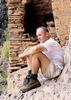
We left Phx early Friday and drove straight to Chiricahua Nat'l Monument. The no-fee entrance was nice. We read that the road to the top of the park was closed just past the campground, so we knew we would need to start our hike at the visitors center--which adds about 3 miles to the big loop hike. No big deal. We had planned to devote the afternoon to hiking anyway.

The parking area was full when we arrived, but we found a spot and after a quick lunch at the TH, we were off on the Lower Rhyolite Trail. I was amazed at the quality of the trail construction. The CCC sure did a great job on this one. If you are a trail architect connoisseur, this is your place. Enjoyed the pine/forest hiking and then headed up Upper Rhyolite and Echo Canyon. We loved the area I think is called "Wall Street," where we weaved in, around and through the narrow pathways through the towering natural skyscrapers. The Grottoes were fun on Echo Canyon as well.

Coming down Ed Riggs was another forest-walking treat, with views of the hoodoos on the opposite canyon wall. Then it was up the drainage along Mushroom Rock trail and out to the junction with Inspiration Point trail. My son and I couldn't pass up the opportunity to see the point, though my wife and daughters were content to continue down towards the Heart of Rocks loop. So, the "boys" picked it up to a jog and took in the views at Inspiration Point, then hustled back to meet up with the "girls," which we did at the Big Balanced Rock.

The Heart of Rocks loop is a real highlight, which kept the camera busy. Then we closed the lollipop part of the big loop off by heading down the Sarah Deming trail, to more forest views. By this point the sun was beginning to get low on the horizon, shading us on the eastern exposure and casting warm light on the hoodoos opposite us on the west and north facing walls of the canyon. The views were beautiful, and the temperatures awesome.

By the time we were finishing off the return trip on Lower Rhyolite, the sun was setting and we arrived to an empty parking lot at the visitors center. I guess you could say we closed down the place.

On our way out, we stopped at the Faraway Ranch day use area, and took advantage of the picnic area and grills to light up some fire and charcoal to enjoy our "camping dinner." We had the place to ourselves. And, after dinner and some s'mores, we packed up and headed back to Benson, where a dip in the jacuzzi, followed by a warm shower were in order. Maybe, the whole campground falling through wasn't such a bad thing after all ....

Got up the next morning and enjoyed a fun tour through the Rotunda and Throne Rooms at Kartchner Caverns and then spent a couple of hours checking out Tombstone before calling it a day and returning to Phoenix.

Great trip!
 Fauna
 Fauna [ checklist ]
[ checklist ]  Acorn Woodpecker
_____________________
  1 archive
Sep 30 2015
avatar

 Guides 27
 Routes 61
 Photos 2,620
 Triplogs 700

69 male
 Joined Jan 23 2008
 Phoenix, AZ
Big Loop - Chiricahua National MonumentTucson, AZ
Tucson, AZ
Hiking avatar Sep 30 2015
AZWanderingBearTriplogs 700
Hiking9.71 Miles 3,140 AEG
Hiking9.71 Miles
3,140 ft AEG
 
1st trip
We were up at dawn on day 4 of our 8-day SE AZ road trip. The night before we'd been chastised by the camp host at Bonita Campground for taking a shower. Apparently no water was allowed to touch the ground inside the campground. We were also not to tie anything to a tree or use the sink in the rest rooms for anything beyond washing our hands. She said we should have brought a lot of baby wipes if we planned to camp and then returned to her 40-foot motor home and ran the generator all night. With a quick breakfast we headed out to the Echo Canyon trailhead, conspiring along the way on the best method for stealth showers.

Started the Big Loop counter clockwise, so down Echo Canyon trail. Doesn't take too long to get to the grottoes. The rhyolite formations are reminiscent of the Fairyland Loop at Bryce in a way. We were all smiles and anxious for what might be ahead. Wall Street was impressive and then we descended into the cool of Echo Canyon. Progress was slow as we took time to ooh and ahh and photograph everything.

Hit the Hailstone Trail and could see across the canyon where we'd be gaining back the elevation we were losing. The Upper Rhyolite turned us back west with several stream crossings. Soon we began the slow slog up the Sarah Deming trail along the west side of the canyon of the same name. While it was a steady uphill, there was shade and the grade was such that we made good time until the last hundred yards or so. The last bit of scrambling brought us back up on top of the formations and right to the beginning of the Heart of Rocks Loop.

The Heart or Rocks Loop is a geologic playground. The trail requires a bit of scrambling and can be difficult to follow at times. We did notice that back in the day someone had painted red footprints on the slick rock areas. While worn, these were still faintly visible at just the right time to keep a careful trekker on the trail. A majority of the named formations are along this trail. Signs point out the more famous -- Duck on a Rock, Punch and Judy, Thors Hammer, Pinnacle Balanced Rock, etc. We took a lunch break amongst the rhyolite formations. On our way back out of the Loop we heard voices and ran into the only hikers we'd see during the entire hike -- a group of ladies who were going clockwise and thus opposite us.

Turned east on Big Balanced Rock Trail and paid homage to its namesake. This trail was level and moderately scenic. We moved quickly. I'd kept the Inspiration Point Trail as a way to extend or shorten the total hike. If we were doing well, then it was out to the point. If we were dragging then we'd blow it off. We didn't even stop to discuss it and turned to the point. The hike is pretty flat. This area was burned years back, so there's not much to see until you hit the end. Then it is just pick a way you want to scramble out to enjoy the view and take photos down the length of Rhyolite Canyon. It was truly inspirational.

The only thing left was Mushroom Rock Trail and then Ed Riggs back to the trailhead. We were tiring and we descended along Mushroom Rock knowing we'd have to climb again right at the end of the hike. It was still pretty, but the heat and the climb made us ready to be reminiscing on how great the day had been as we sipped a cold one back in camp.

With high spirits and high fives we topped out at the parking lot. Definitely the highlight of our days in the Chiricahuas.
 Geology
 Geology [ checklist ]
[ checklist ]  Rhyolite
wildflower observationwildflower observationwildflower observationwildflower observationwildflower observation
Wildflowers Observation Light

water 1 out of 5water less than maxwater less than maxwater less than max Echo Canyon Pools to trickle Pools to trickle

water 1 out of 5water less than maxwater less than maxwater less than max Hunt Canyon Pools to trickle Pools to trickle

water 1 out of 5water 2 out of 5water 3 out of 5water less than max Sarah Deming Canyon Medium flow Medium flow
Nice flow down in the canyon

water 1 out of 5water less than maxwater less than maxwater less than max Totem Canyon Pools to trickle Pools to trickle
_____________________
All you have is your fire...
And the place you need to reach
  4 archives
Sep 26 2015
avatar

 Guides 6
 Routes 183
 Photos 5,612
 Triplogs 1,647

male
 Joined Mar 12 2004
 Scottsdale, AZ
Big Loop - Chiricahua National MonumentTucson, AZ
Tucson, AZ
Hiking avatar Sep 26 2015
John9LTriplogs 1,647
Hiking9.16 Miles 1,994 AEG
Hiking9.16 Miles
1,994 ft AEG
 
no photosets
1st trip
Our original plan for the day was to drive up to Rustler Park and hike to Chiricahua Peak. The forest service told us the road was open for the weekend but will be closed on Monday for two weeks. We discovered the road was closed with no access to Rustler Park. We both scratched our heads and thought what a joke! We decided to return to the Monument and hit the Big Loop which we planned on hiking the next day.

We parked in the Echo Canyon parking lot and headed south. All of these trails are in excellent condition and are well signed. We made quick time as we dropped into a valley and then made the easy climb up the other side. From there we detoured over to Inspiration Point and admired the view. We got there relatively early so we took a quick break and continued on to the Heart of Rocks. This is a sweet area with cool formations. We took a lunch here and enjoyed the views.

After lunch we finished the loop and then continued down the Sarah Deming Trail and headed towards Echo Canyon. This is another sweet area with cool formations. The going was very easy as we gained elevation and topped out around early afternoon. This is the premier hike in the Monument and well worth your time.
_____________________
  2 archives
Sep 26 2015
avatar

 Photos 188
 Triplogs 163

43 female
 Joined Oct 26 2011
 Tempe, AZ
Big Loop - Chiricahua National MonumentTucson, AZ
Tucson, AZ
Hiking avatar Sep 26 2015
clairebearTriplogs 163
Hiking9.16 Miles 1,994 AEG
Hiking9.16 Miles
1,994 ft AEG
 no routesno photosets
1st trip
9L and I had set our sights on bagging Chiricahua Peak and despite the assurance of the rangers, the access road to Rustler Park was closed :o . We decided to just move things up a day and therefore we would do the Loop of the National Monument. On our way back down the road, 9L got a flat so once back on pavement we pulled off to fix the flat and then onto Echo Canyon and the start of our hike.

Nice and easy to follow trail system without the crowds of other national parks.
We only passed a few people the whole day and enjoyed the cool rock scenery!
_____________________
 
Dec 27 2014
avatar

 Guides 7
 Routes 72
 Photos 14,456
 Triplogs 627

62 female
 Joined Aug 19 2011
 Scottsdale, AZ
Chiricahua ShuttleTucson, AZ
Tucson, AZ
Car Camping avatar Dec 27 2014
outdoor_loverTriplogs 627
Car Camping
Car Camping2 Days         
 no routes
1st trip
Partners none no partners
I've seen the Monument once, about 15 Years ago when I first realized that there was a cool Mountain Range down there. I was working a Highway Job in Sunizona and when I asked people if there was anything Cool to see or do down there in my Off Time, the Monument was the first thing to come up. I took a couple of Trips out to the Chiricahuas while I was working down there. Always, right after Work, as I was staying in Willcox. I went up into the Turkey Creek Area one Day and explored a little bit. The other Day, I went to the Monument. I had enough Time to drive all the way up to Massai Point, go OMG! and then it got Dark.... :sl:

This was the Trip to really check it out...I knew I probably wouldn't get much Hiking in, but it was a great "Get Acquainted" Trip. I Camped for 2 Nights, arriving after Dark the first Night, after Birding Kansas Settlement. I spent 1 1/2 Days messing around in there. This Triplog and Photoset is just from the First Day. I did a slightly longer Hike and History Tour on the 2nd Day, so I'm going to do it separately...

It was pretty Chilly at Night and they had gotten some Snow from the Storm that hit me at Whitewater Draw....I had a thought to do Sugarloaf Mountain while I was there, but one look at the Trail, in the Shade, with all of the Recent Snow on it, was enough for me to say "next time".... :sweat: I'm just not equipped for Snow Hikes.

I drove the Road, did the Nature Trail Hike at Massai Point, checked out all of the Overlooks and TH's, and did a small Loop Hike from the Campground to the Visitor Center. Back up to Massai Point for Sunset... :D

Amazing Place and I will be back to start taking on some of those cool Hikes... :D
 Meteorology
 Meteorology [ checklist ]
[ checklist ]  Sunset

dry Bonita Canyon Dry Dry
Dry at Campground

dry Madrone Canyon Dry Dry
Dry along Trail from Campground to Ranger Station.
_____________________
Life is not a journey to the grave with the intention of arriving safely in a pretty & well preserved body, but rather to skid in broadside, totally worn out & proclaiming, "Wow What a Ride!"
 
May 30 2014
avatar

 Guides 1
 Routes 136
 Photos 22,415
 Triplogs 1,041

77 male
 Joined Feb 28 2003
 Tucson, AZ
Chiricahua Camping Again, AZ 
Chiricahua Camping Again, AZ
 
Car Camping avatar May 30 2014
rwstormTriplogs 1,041
Car Camping
Car Camping
 no routes
1st trip
Partners none no partners
I wanted to return to camp at the monument to make up for being with that rowdy group last week and apologize to the campground host. He said, "Yeah I thought you looked familiar." He said there were a few complaints. Good, I didn't get banned from staying again! :sweat: :lol: The experience reminded me why I really prefer to be solo on these adventures (or at least with only a few other very like-minded folks). ;) Anyway, I got down there pretty early Friday and it was going to be very warm that low, so I drove up the mountain to see how things looked at Rustler and Barfoot Parks and kill some time at the cooler 8500 foot level.

When I got back to the monument in the afternoon it was still plenty warm, but I picked a site, paid my 6 bucks (half price for me), set up the tent, then drove to Massai Point for awhile, before coming back to camp to enjoy the evening. I get to the Chiricahua Mountains fairly often, but rarely to the monument. It really is a wonderful place! :)
wildflower observationwildflower observationwildflower observationwildflower observationwildflower observation
Wildflowers Observation Isolated
_____________________
 
May 27 2014
avatar

 Guides 4
 Photos 4,732
 Triplogs 2,607

55 male
 Joined Sep 29 2004
 Small Town USA
Chiricahua ShuttleTucson, AZ
Tucson, AZ
Hiking avatar May 27 2014
SkyIslander18Triplogs 2,607
Hiking10.25 Miles 1,750 AEG
Hiking10.25 Miles
1,750 ft AEG
 no routes
- Inaugural Roper Lake State Park Ranger Hiking Club Adventure-
Starring Myself, Addie & Lauren

And there couldn't have been a better place to start then the Chiricahua National Monument!!!

We decided on the shuttle service to drop us off at Massai Point to start. On the drive up, I was telling the driver how I had come across a black bear in the road several years ago in the spot that we were driving, 30 seconds later we rounded a corner and holy :pk: there was a Huge black bear standing in the middle of the road :o What a thrill and I got a pretty good shot of him before he moved up the embankment!

From Massai Point we headed down into the HooDoo maze and spent the next 6 hours taking in all the splender of this truly amazing place, I shall never get tired of this Monument!
My 2 fellow hiking Rangers were just an absolute blast to see it all with and I can't remember the last time I have laughed so much on a hike! I also cannot remember the last time I've hiked the Monument and took under 25 pictures, but today was just about having a damn good time with 2 awesome friends - Thanks AS & LM, look very forward to #2,#3,#4 .....
 Fauna
 Fauna [ checklist ]
[ checklist ]  Black Bear
_____________________
https://www.instagram.com/skyislander22/
  3 archives
Apr 24 2014
avatar

 Photos 2,699
 Triplogs 240

female
 Joined Oct 31 2007
 Middle-of-Nowher
Chiricahua ShuttleTucson, AZ
Tucson, AZ
Hiking avatar Apr 24 2014
snakemarksTriplogs 240
Hiking8.70 Miles 1,600 AEG
Hiking8.70 Miles
1,600 ft AEG
 no routes
Linked   none no linked trail guides
Partners none no partners
Took my son here for some different scenery. We camped the night before on Pinery Canyon Rd - had the entire place to ourselves. It was pretty chilly at night, but the perfect temp for hiking the next day.

We took the shuttle up to Echo Canyon and hiked Echo > Hailstone > Mushroom Rock > Big Balanced Rock > Heart of Rocks > Sarah Demming > Lower Rhyolite > Visitor's Center. We skipped Inspiration Point, as it seemed to have the worst fire damage. The junction of Inspiration Pt. with the Mushroom Rock Tr. and the Big Balanced Rock Tr. was really torched. There is much new growth, but it will be a long time before shade happens there again. Fortunately, the best parts of the park were untouched (Upper Echo Canyon, the west side of Big Balanced Rock Tr. and the Heart of Rocks). It's still very much worth the trip.

Compliments, once again, to the Park Service who runs this place. They really are a class act.
wildflower observationwildflower observationwildflower observationwildflower observationwildflower observation
Wildflowers Observation Isolated
_____________________
I'm at home in the wilderness... it's civilization I have problems with! ](*,)
 
Nov 20 2012
avatar

 Guides 4
 Photos 4,732
 Triplogs 2,607

55 male
 Joined Sep 29 2004
 Small Town USA
Big Loop - Chiricahua National MonumentTucson, AZ
Tucson, AZ
Hiking avatar Nov 20 2012
SkyIslander18Triplogs 2,607
Hiking9.85 Miles 2,024 AEG
Hiking9.85 Miles   6 Hrs   5 Mns   2.07 mph
2,024 ft AEG   1 Hour   19 Mns Break
 no routes
My first trip back into the upper Monument since the fire!

We first started with a warm-up on the Massai Nature Trail loop before driving back down to the Echo Canyon trailhead. We then completed the Big Loop hiking it clockwise including the out-n-back to Inspiration Point. I really expected to see a lot more burn, but the only sections that really got cooked were the Southeast corner including the entire Inspiration Point trail & Echo Park down in the lower canyon. There was a few other spotty burn sections, but nothing too bad.

As for the rest of the trail(s), I was once again just blown away with the Monument scenery! The formations & trails (as always) were amazing, spectacular, epic, etc ........
In my opinion, this is still "the one" to do in Southeastern Arizona!

What made this trip even better was sharing it with 2 new friends I made at Roper Lake SP just a couple of days earlier. It was their first time seeing the Monument and I heard more then a few WOWS during the hike.

Thanks Dave & Kathy, you guys (and the hoodoos) Rocked!!!
foliage observationfoliage observationfoliage observationfoliage observationfoliage observation
Autumn Foliage Observation Light
wildflower observationwildflower observationwildflower observationwildflower observationwildflower observation
Wildflowers Observation Isolated
_____________________
https://www.instagram.com/skyislander22/
  1 archive
Nov 09 2012
avatar

 Guides 71
 Routes 98
 Photos 9,967
 Triplogs 1,009

65 male
 Joined May 14 2003
 Ahwatukee, AZ
Bassett PeakTucson, AZ
Tucson, AZ
Backpack avatar Nov 09 2012
Randal_SchulhauserTriplogs 1,009
Backpack17.55 Miles 2,750 AEG
Backpack17.55 Miles3 Days         
2,750 ft AEG
 
Bassett Peak Tales 2012

3 days
607 miles
33 gallons of gasoline
266 digital images
Fall colours
"Robber" stellar jays
Clean, crisp mountain air (with just a hint of snow)
Unexpected solitude
No work distractions
Priceless!

The Plan => Friday 11/9 rendezvous at Einstein's Bagels in Ahwatukee AZ, truck pool, and hit the road to the Bassett Peak trail head at the end of FR660/Ash Creek Road to set up camp in the Galiuro Mountains to enjoy what many consider the best fall colours in Arizona.

I've been able to keep my 2012 quarterly wilderness adventures pretty much as planned; "Anza Borrego California Tales 2012" (check out => [ photoset ] ), "Oregon Tales 2012" (check out => [ photoset ] ), and Colorado Fall Colours 2012" (check out => [ photoset ] ). Those 3 days crossed out on the November calendar to take in the Bassett Peak fall colours at Ash Spring were about to be tested...

Thursday started out with 6 adventurers ready and raring to go, by sundown there was only 1. Weather forecasts and other calamities took their toll. With Friday already booked off, I decided to roll the dice and use the Willcox Holiday Inn Express as basecamp with some adjusted plans;

A. Ahwatukee AZ - ground zero, home
B. Willcox AZ - basecamp at the Holiday Inn Express (check out => https://www.willcoxlodging.com/)
C. Fort Bowie National Historic Site - stop at the old fort (check out => https://www.nps.gov/fobo/index.htm and [ Fort Bowie Loop ] )
D. San Simon AZ - S. Noland Rd. turn-off to head south to Portal AZ and the South Fork of Cave Creek TH in Chiricahua National Monument
E. South Noland Road - note; signage is not "San Simon Road" as noted in HAZ write-ups
F. Foothills Road - turn-off to SE towards Portal AZ
G. Portal AZ - SE access to Chiricahua National Monument (check out => https://www.nps.gov/chir/index.htm and [ Chiricahua Shuttle ] )
H. South Fork of Cave Creek TH - access at the South Fork picnic area (check out => [ South Fork of Cave Creek #243 ] )
I. Forest Road 42 - up and over the Chiricahua Mountains (check out => https://www.fs.usda.gov/recarea/coronad ... &actid=105)
J. Dos Cabezas AZ - a drive back to Willcox via SR186
K. Willcox AZ - basecamp at the local Holiday Inn Express (check out => https://www.willcoxlodging.com/)
L. Bassett Peak TH - end of the road for FR660/Ash Creek Road in the Galiuro Mountains (check out => [ Bassett Peak ] )
M. Tucson AZ - Sunday dinner with my youngest daughter, Tobyn
N. Ahwatukee AZ - home again...

DAY 1 - Friday 11/9
Ahwatukee AZ to Willcox AZ
185 miles
3 hrs 1 min 1-way per Google Maps

Hit the road for the Willcox AZ basecamp.

DAY 2 - Saturday 11/10
Willcox AZ to South Fork of Cave Creek Trail #243 via FOBO and FR42 to SR186
96 miles
3 hrs 34 min per Google Maps

I have never been to the Chiricahua Mountains before and thought I could take advantage of being in the vicinity. My home library contains the book "Cochise - the Life and Times of the Great Apache Chief" by ASU professor Peter Aleshire (check out => https://www.amazon.com/Cochise-Times-Gr ... ikearizona ). Despite the literary criticism, I've always been intrigued by this book and the subject (an easier read about Cochise was authored by Dave Roberts). It's arguable that the existence of Fort Bowie can be attributed to Chief Cochise, so it was fitting to make the side trek. Upon entry to the site, I discover the cool nickname for Fort Bowie - FOBO, uttered by one of the staff (FOBO is now forever burned into my brain). A quick tour of FOBO Loop followed by a pondering about the location of the tent Cochise cut open to make his escape in 1861 (check out => https://www.nps.gov/fobo/historyculture ... elix-3.pdf ) during the "Bascom Affair". The low hanging clouds created a fittingly eerie FOBO atmosphere...

The main objective of the day was exploring South Fork of Cave Creek Trail #243 and the fall colours I've heard raves about from some HAZ trekkers and others. Maple Camp would be the primary objective given some of the photos I've seen. I arrived at the picnic area at the end of South Fork Road noon-ish. A group of 3 hunters decked out in full camouflage were exiting the trail as I began my trek. They said they managed to get a single shot off during their morning hunt - I indicated I hoped to get considerably more (digital) shots off that afternoon... I arrived at the Maple Camp area wondering what all the fuss is about. Undeterred, I trekked another 2 miles or so upstream from the Burro Trail junction seeking fall colours. I have to agree with Letty's recent assessment (check out => [ photoset ] ) and look forward to area recovery to its former blazing colours. I returned to the TH with just enough remaining daylight to spark-up the BBQ and grill a couple of burgs. To my complete surprise, I discovered a robbery in process - Stellar Jays landing on my picnic table and helping themselves to my Doritos - with me only an arm's length away!

I returned to my Willcox basecamp via Forest Road 42 up and over the Chiricahua Mountains to join up with SR186 near Dos Cabezas. When I packed up and left the South Fork picnic area my truck thermometer indicated it was 48degF. As I peaked-out along the Chiricahua ridgeline, my truck thermometer indicated it was a chilly 34degF!

DAY 3 - Sunday 11/10
Willcox AZ to Bassett Peak TH (Ash Creek Rd/FR660)
36 miles
1 hr 37 min per Google Maps

Sunday sunrise revealed a brilliant blue cloudless sky with snow visible on the highest mountain peaks. I slowly made my way to the trail head stopping many times to observe the various eye-candy (I still regret passing up the pumpkin field and failing to re-create the image captured by Derek von Briesen => https://www.pbase.com/sedonamemories/image/128206856 ) including snow on Mount Graham. As I turned onto FR660 near the intersection of Ash Creek Road and Sunset Loop, I was surprised to see nobody at the usually busy "hunter's meadow". Saw one group of campers at the large site as you exit the wash and another group at the almost-TH. I parked my truck here and discovered the campers were mostly from Mesa AZ. They indicated it had snowed overnight accompanied by some strong winds. Once on the trail, I was treated to a riot of colour (albeit a week past their prime). At Ash Spring, the aspen still had about half their leaves. Another one of the old growth aspen fell victim to the weekend winds - every time I've visited there's another old growth casualty. Without any new growth aspen, I wonder how many more years we'll have to enjoy this spectacular scene??? After capture my fill of fall colours, I packed up my gear with a dinner stop in Tucson visiting my daughter Tobyn.

And that's my Bassett Peak Tale 2012! Photos to follow...
 Fauna
 Fauna [ checklist ]
[ checklist ]  Mexican Jay
_____________________
 
Nov 02 2012
avatar

 Guides 1
 Routes 43
 Photos 666
 Triplogs 78

60 male
 Joined Mar 15 2012
 Sonoita, AZ
Tour de Baja Arizona Section IV, AZ 
Tour de Baja Arizona Section IV, AZ
 
Mtn Biking avatar Nov 02 2012
MAVMTriplogs 78
Mtn Biking166.46 Miles 15,191 AEG
Mtn Biking166.46 Miles5 Days         
15,191 ft AEG4 Days   1 Hour    Break100 LBS Pack
 
1st trip
Linked   linked  
Partners none no partners
Tour de Baja Arizona Section IV - Hot Well Dunes to Whitewater Draw

Having been continually working to manage a herniated L5 disc since January of this year - I recently devoted a good deal of time over the past three months toward Physical Therapy (PT). This involved little to no hiking - but did allow for increased cycling of all types - much of it measured on an indoor wind-trainer a minimum of 5 days per week. Trail riding and continuing research for a route I've been crafting - the Tour de Baja Arizona (TDBAZ) - made up most of the summer. The test route documented here outlines a variation involving Section IV of the tour. I intend to divide this route into into four sections, each averaging between 150 - 170 miles for a circuitous total of around 640 miles or over 1000 km. The bulk of each section is over dirt forest roads (100 miles +) with some single track trail riding when applicable - elevation is engaged not avoided. I carried all food necessary and took water solely from the route, with a 3.25 gallon capacity available. The only exception to this was the off-day in Rodeo, New Mexico - where I dined and took water in a conventional manner while remaining camped for two nights - as I needed to do laundry somewhere. The weight of the bike and gear used fluctuated between 90 - 110lbs.< mainly dependent on water load. I was fortunate to find water available in the creek beds below my camps in both Pinery Canyon & Rucker Canyon in the Chiricahua Mountains - this was a gamble that paid-off by allowing me to carry less water over some of the steepest climbs. I rode fully loaded with over 3.25 gallons on board upon leaving camp at Hot Well Dunes and ran out the following morning on the uphill grade entering Chiricahua National Monument. This gave me a good seasonal assessment as to the range of the set-up, etc. I feel good about this outing and that my PT over 2012 is definitely heading in the right direction! The photos are mainly of campsites with the bike and such - a few landscapes are included.

:SB: 
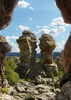
Having recently (earlier this month) traversed the Chiricahuas by Mountain Bike, I was able to inquire about Rustler Park with a good many regional folks. The story was consistent from the Chiricahua Monument to Portal, AZ / Rodeo, NM... Word is that a minimum of 1000 burned or scorched trees are going to be logged off at Rustler Rark - most of this will be performed by onsite mobile sawmills brought up the mountain with finished lumber trucked-off - with much of the excelsior remains being incorporated into a portion of erosion control, etc. Barfoot Park has remained open escaping a good deal of recent fire damage - except for the Fire Lookout... I hiked about Rustler Park (currently closed) while doing a Truck Camping overnight to research water availability back in Mid-October for the MTB ride through the area. Barfoot is a real gem of seclusion at 8,300'...
 Culture
 Culture [ checklist ]
[ checklist ]  HAZ Rides
foliage observationfoliage observationfoliage observationfoliage observationfoliage observation
Autumn Foliage Observation Substantial

water 1 out of 5water 2 out of 5water less than maxwater less than max Maggie Tank 26-50% full 26-50% full
Went off the road to check on this tank in an isolated fully exposed area. An oasis in the region.

water 1 out of 5water 2 out of 5water less than maxwater less than max Silver Spur Spring Quart per minute Quart per minute
Nominal flow observed while hiking about the area.
_____________________
The MaNtiS - Assume & be Damned!
http://www.mavm.com
 
average hiking speed 2.31 mph
1, 2, 3, 4, 5, 6  Next

WARNING! Hiking and outdoor related sports can be dangerous. Be responsible and prepare for the trip. Study the area you are entering and plan accordingly. Dress for the current and unexpected weather changes. Take plenty of water. Never go alone. Make an itinerary with your plan(s), route(s), destination(s) and expected return time. Give your itinerary to trusted family and/or friends.

helpcommentissue

end of page marker