|
| | | |
| |
|
| Hiking | 10.35 Miles |
1,460 AEG |
| | Hiking | 10.35 Miles | 4 Hrs 12 Mns | | 2.46 mph |
| 1,460 ft AEG | | | | |
|
|
| |
| Partners |
|
[ show ]
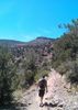
| partners | | Today's Prescott Circle Trail segment included Turley Trail and Boy Scout Trail #126, part of Ranch Trail #62, and the beginning of Goldwater Lakes Trail #396.
We only saw one hiker all day, and that was a guy who rolled up as we were fiddling about Turley TH. No dog walkers, horse riders or trail runners. A half dozen MTBs in our first hour on Trail #62. Those guys, and a gal, were peddling uphill faster than I do downhill! 
Exposed & brushy Turley follows the contour for a mile, before dropping 100 ft. to the pine-shaded lower reaches of Government Canyon. After two miles, the PCT turns left off Government Canyon, heading up towards Section 12 Spring.
Even before the summer monsoon starts in a few weeks, there was some water in the creek bottom. Beyond the gate, Turley Trail changes names to Trail #126.
Despite mosquitoes, the half mile above & below Section 12 Spring are the highlight of this PCT segment. The spring box was disconnected & dry. I did not spot he spring itself, which must be a seep in the small grassy area 200 ft. above the box. An out & back hike from Turley TH to the spring would be 6⅓ miles, 1100 ft. AEG.
Once we got to Trail #62, the next half mile was brushy & exposed. The PCT has been MTB-optimized along most of its length. Since I last hiked Trail #62 in 2014 ( [ photoset ] ), the quarter mile south of Ranch Trail #62 has been tripled in length with switchbacks. From the direction we were hiking, it was blocked with brush; at the far end, a carbonite sign. The current, correct, route is attached.
From the top of the Trail #62 reroute, PCT follows the windy contour along the mostly shady north slope of a ridge. I kept Paul amused trying to remember which rock it was where I almost sat on the poopy underwear in 2014. 
Depending on your location along Trail #62, there are good views from Bear Down Peak, to the east of Lynx Lake, west to Mount Francis. (Not the whole 180° at once though!) Unfortunately, my iPhone SE does not zoom well.
It was turning into a long day when Paul & I made the turn south into more sun-exposed brush along the west side of Hill 6684. Thankfully, the PCT begins descending to the Senator Hwy. On the west side of the highway, the PCT becomes Goldwater Lakes Trail #396 — a fast, rolling, MTB track. I would have liked to stop for a rest at Bannon Creek, but my wife was waiting for us up at the Goldwater Lake boat ramp.
Imagine my excitement when I saw they sold ice cream! 
Imagine my disappointment when I realized they are closed during the week … 
Hiking Video: https://vimeo.com/839441666 |
|
Wildflowers Observation Light
Large, dense, clusters of pygmy bluet. 100 ft. of orange rust on unknown shrubs near Section 12 Spring. Also photographed yellow columbine, Colorado four o'clock, Arizona thistle, scarlet penstemon, Wood's rose, New Mexico Locust, Dalmatian toadflax, Gooding's verbena, pineywoods geranium, and twistspine pricklypear. No photos for red & yellow pea, silverleaf nightshade, fleabane or hoary aster. |
|
| _____________________
| http://prestonm.com : Everyone's enjoyment of the outdoors is different and should be equally honored. |
| | |
|
|
|
 Route Editor


 the beginner trails Green Bean, Mr. Bean, Rice and Beans, and Beany Baby, at Bean Peaks Gravity Flow Trails -- a new system at White Spar, just south of Prescott.